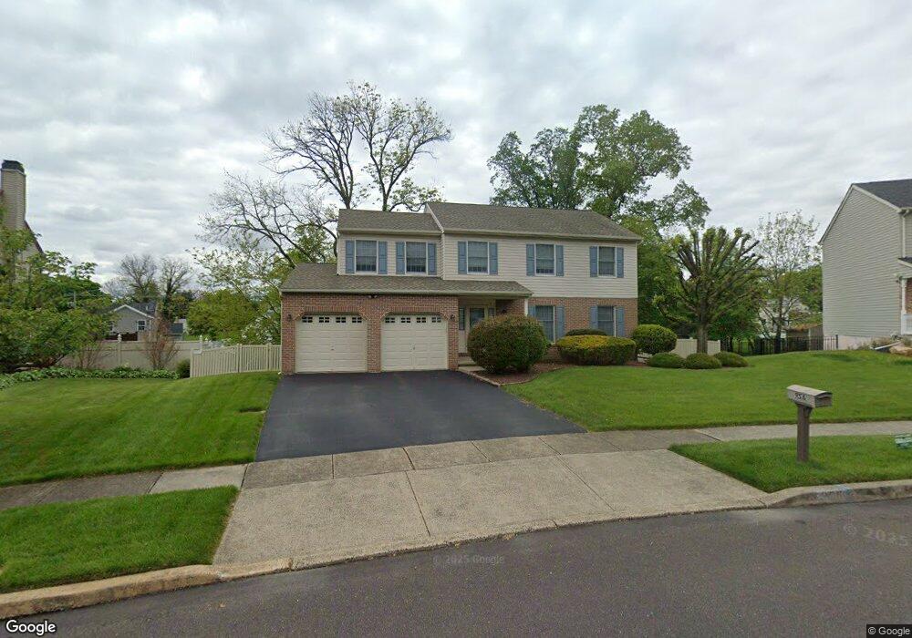
956 Duxbury Dr Langhorne, PA 19047
Estimated Value: $550,000 - $645,634
4
Beds
3
Baths
2,304
Sq Ft
$266/Sq Ft
Est. Value
About This Home
This home is located at 956 Duxbury Dr, Langhorne, PA 19047 and is currently estimated at $612,159, approximately $265 per square foot. 956 Duxbury Dr is a home located in Bucks County with nearby schools including Hoover Elementary School, Maple Point Middle School, and Neshaminy High School.
Ownership History
Date
Name
Owned For
Owner Type
Purchase Details
Closed on
Feb 11, 1994
Sold by
Attleboro Builders Inc
Bought by
Dipaolo John M and Dipaolo Margaret T
Current Estimated Value
Home Financials for this Owner
Home Financials are based on the most recent Mortgage that was taken out on this home.
Original Mortgage
$100,000
Interest Rate
7.18%
Purchase Details
Closed on
Oct 19, 1993
Bought by
Attleboro Bldr Inc
Create a Home Valuation Report for This Property
The Home Valuation Report is an in-depth analysis detailing your home's value as well as a comparison with similar homes in the area
Home Values in the Area
Average Home Value in this Area
Purchase History
| Date | Buyer | Sale Price | Title Company |
|---|---|---|---|
| Dipaolo John M | $178,000 | -- | |
| Attleboro Bldr Inc | $470,900 | -- |
Source: Public Records
Mortgage History
| Date | Status | Borrower | Loan Amount |
|---|---|---|---|
| Closed | Dipaolo John M | $100,000 |
Source: Public Records
Tax History Compared to Growth
Tax History
| Year | Tax Paid | Tax Assessment Tax Assessment Total Assessment is a certain percentage of the fair market value that is determined by local assessors to be the total taxable value of land and additions on the property. | Land | Improvement |
|---|---|---|---|---|
| 2025 | $7,637 | $35,080 | $4,520 | $30,560 |
| 2024 | $7,637 | $35,080 | $4,520 | $30,560 |
| 2023 | $7,516 | $35,080 | $4,520 | $30,560 |
| 2022 | $7,318 | $35,080 | $4,520 | $30,560 |
| 2021 | $7,318 | $35,080 | $4,520 | $30,560 |
| 2020 | $7,231 | $35,080 | $4,520 | $30,560 |
| 2019 | $7,069 | $35,080 | $4,520 | $30,560 |
| 2018 | $6,940 | $35,080 | $4,520 | $30,560 |
| 2017 | $6,762 | $35,080 | $4,520 | $30,560 |
| 2016 | $6,762 | $35,080 | $4,520 | $30,560 |
| 2015 | $6,952 | $35,080 | $4,520 | $30,560 |
| 2014 | $6,952 | $35,080 | $4,520 | $30,560 |
Source: Public Records
Map
Nearby Homes
- 2816 Avenue E
- 2823 Avenue E
- 0 Prospect Ave
- 731 Highland Ave
- 1516 Fairview Ave
- 1420 Super Hwy
- 710 Fox Ct
- 1632 Winter Ave
- 565 Hulmeville Rd
- 790 E Parker St Unit A1
- 801 E Parker St Unit B2
- 1605 Old Lincoln Hwy
- 449 Grand Ave
- 6351 Shewell Rd
- 523 Turtle Ln
- 56 W Lincoln Hwy
- 409 Fairview Ave
- 3225 Ethan Allen Ct
- 1210 Brownsville Rd
- 6561 Neshaminy Valley Dr