Estimated Value: $962,000 - $1,100,000
5
Beds
4
Baths
4,714
Sq Ft
$219/Sq Ft
Est. Value
About This Home
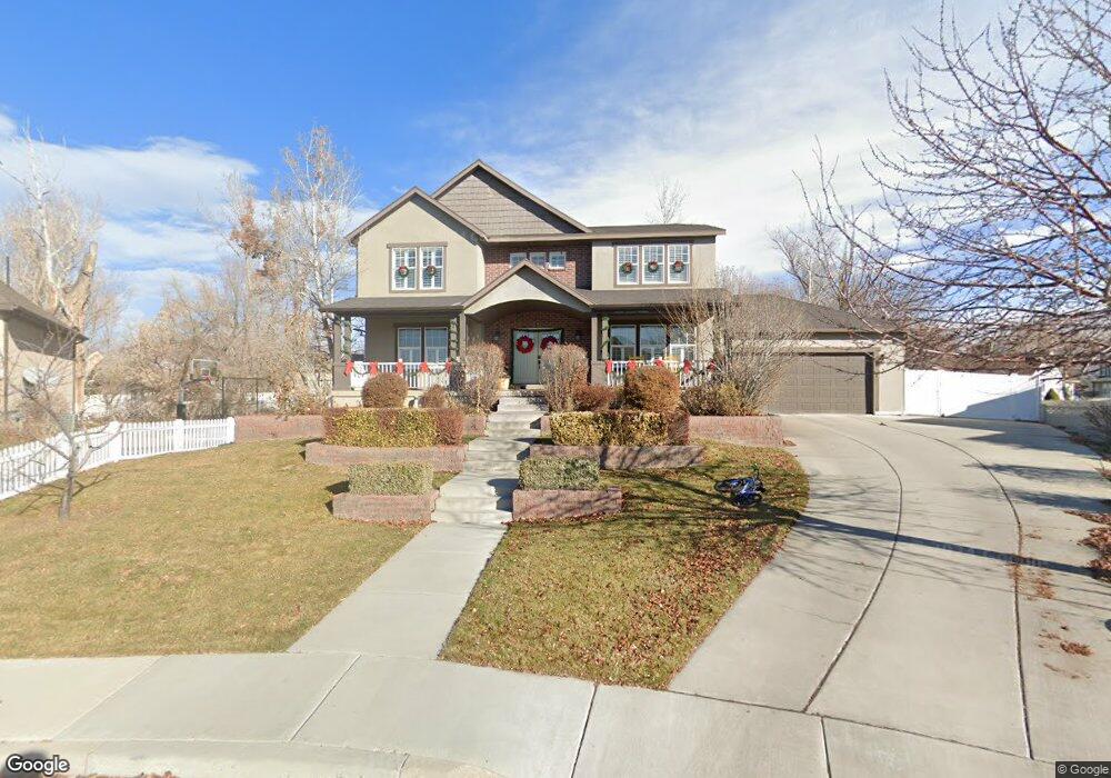
This home is located at 956 W 550 N, Lehi, UT 84043 and is currently estimated at $1,031,452, approximately $218 per square foot. 956 W 550 N is a home located in Utah County with nearby schools including Lehi Elementary School, Lehi Junior High School, and Lehi High School.
Ownership History
Date
Name
Owned For
Owner Type
Purchase Details
Closed on
May 2, 2017
Sold by
Salcido Gerald Michael
Bought by
Salcido Melissa
Current Estimated Value
Purchase Details
Closed on
Apr 28, 2011
Sold by
Salisbury Josh and Salisbury Elizabeth
Bought by
Salcido Gerald M
Home Financials for this Owner
Home Financials are based on the most recent Mortgage that was taken out on this home.
Original Mortgage
$310,400
Outstanding Balance
$215,316
Interest Rate
4.84%
Mortgage Type
New Conventional
Estimated Equity
$816,136
Purchase Details
Closed on
Nov 16, 2007
Sold by
Salisbury Josh
Bought by
Salisbury Josh and Salisbury Elizabeth
Home Financials for this Owner
Home Financials are based on the most recent Mortgage that was taken out on this home.
Original Mortgage
$368,000
Interest Rate
6.38%
Mortgage Type
New Conventional
Purchase Details
Closed on
Mar 19, 2007
Sold by
Luce Robert E and Luce Debra L
Bought by
Salisbury Josh
Create a Home Valuation Report for This Property
The Home Valuation Report is an in-depth analysis detailing your home's value as well as a comparison with similar homes in the area
Home Values in the Area
Average Home Value in this Area
Purchase History
| Date | Buyer | Sale Price | Title Company |
|---|---|---|---|
| Salcido Melissa | -- | None Available | |
| Salcido Gerald M | -- | First American Orem | |
| Salisbury Josh | -- | Premier Title Insurance Age | |
| Salisbury Josh | -- | Affiliated First Title Comp |
Source: Public Records
Mortgage History
| Date | Status | Borrower | Loan Amount |
|---|---|---|---|
| Open | Salcido Gerald M | $310,400 | |
| Previous Owner | Salisbury Josh | $368,000 |
Source: Public Records
Tax History Compared to Growth
Tax History
| Year | Tax Paid | Tax Assessment Tax Assessment Total Assessment is a certain percentage of the fair market value that is determined by local assessors to be the total taxable value of land and additions on the property. | Land | Improvement |
|---|---|---|---|---|
| 2025 | $3,870 | $513,370 | $294,100 | $639,300 |
| 2024 | $3,870 | $452,870 | $0 | $0 |
| 2023 | $3,651 | $463,925 | $0 | $0 |
| 2022 | $3,758 | $462,880 | $0 | $0 |
| 2021 | $3,405 | $634,200 | $170,200 | $464,000 |
| 2020 | $3,212 | $591,200 | $157,600 | $433,600 |
| 2019 | $2,794 | $534,600 | $157,600 | $377,000 |
| 2018 | $2,771 | $501,300 | $135,100 | $366,200 |
| 2017 | $2,824 | $271,590 | $0 | $0 |
| 2016 | $2,975 | $265,485 | $0 | $0 |
| 2015 | $3,018 | $255,695 | $0 | $0 |
| 2014 | $2,590 | $218,130 | $0 | $0 |
Source: Public Records
Map
Nearby Homes
- 578 N Woods Dr
- 443 W 820 N
- 1035 W Main St
- 1032 Titan Dr
- 1301 N 900 W Unit 12
- 953 W 125 S
- 975 W 125 S
- 1031 W 125 St S
- 1132 Titan Dr
- 485 W Main St
- 1215 W 125 S
- 996 N 200 W
- 143 W 300 N
- 255 W 100 N
- 1127 N 1500 W
- 4561 N McKechnie Way Dr Unit 1119
- 155 W State St Unit TRLR 3
- 1094 W 1425 N
- 285 S 660 W
- 68 W State St