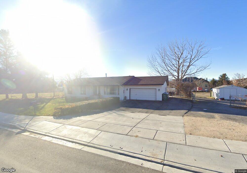
9565 N 6800 W American Fork, UT 84003
Estimated Value: $887,000
5
Beds
3
Baths
1,898
Sq Ft
$467/Sq Ft
Est. Value
About This Home
This home is located at 9565 N 6800 W, American Fork, UT 84003 and is currently priced at $887,000, approximately $467 per square foot. 9565 N 6800 W is a home located in Utah County with nearby schools including Freedom Elementary School, Lehi Junior High School, and Skyridge High School.
Ownership History
Date
Name
Owned For
Owner Type
Purchase Details
Closed on
Jun 8, 2022
Sold by
Lynn Shock Tyler and Lynn Rick
Bought by
Highland City
Current Estimated Value
Purchase Details
Closed on
Mar 30, 2022
Sold by
Lynn Shock Tyler
Bought by
Shock Tyler Lynn and Shock Rick
Home Financials for this Owner
Home Financials are based on the most recent Mortgage that was taken out on this home.
Original Mortgage
$369,400
Interest Rate
4.42%
Mortgage Type
New Conventional
Purchase Details
Closed on
Jan 29, 2018
Sold by
Wilson Mark G and Wilson Beverly B
Bought by
Shock Tyler Lynn and Shock Kimberly Miller
Home Financials for this Owner
Home Financials are based on the most recent Mortgage that was taken out on this home.
Original Mortgage
$388,000
Interest Rate
3.93%
Mortgage Type
New Conventional
Create a Home Valuation Report for This Property
The Home Valuation Report is an in-depth analysis detailing your home's value as well as a comparison with similar homes in the area
Home Values in the Area
Average Home Value in this Area
Purchase History
| Date | Buyer | Sale Price | Title Company |
|---|---|---|---|
| Highland City | -- | First American Title | |
| Shock Tyler Lynn | -- | Truly Title | |
| Shock Tyler Lynn | -- | Old Republic Title |
Source: Public Records
Mortgage History
| Date | Status | Borrower | Loan Amount |
|---|---|---|---|
| Previous Owner | Shock Tyler Lynn | $369,400 | |
| Previous Owner | Shock Tyler Lynn | $388,000 |
Source: Public Records
Tax History Compared to Growth
Tax History
| Year | Tax Paid | Tax Assessment Tax Assessment Total Assessment is a certain percentage of the fair market value that is determined by local assessors to be the total taxable value of land and additions on the property. | Land | Improvement |
|---|---|---|---|---|
| 2022 | $3,142 | $377,135 | $0 | $0 |
| 2021 | $2,642 | $476,700 | $235,800 | $240,900 |
| 2020 | $2,467 | $436,600 | $205,000 | $231,600 |
| 2019 | $2,220 | $406,400 | $205,000 | $201,400 |
| 2018 | $2,203 | $382,700 | $200,000 | $182,700 |
| 2017 | $1,545 | $199,485 | $0 | $0 |
| 2016 | $1,614 | $173,910 | $0 | $0 |
| 2015 | $454 | $157,575 | $0 | $0 |
| 2014 | $509 | $171,325 | $0 | $0 |
Source: Public Records
Map
Nearby Homes
- 9435 N Aspen Hollow Cir
- 6692 W 9770 N
- 893 N 1580 E
- 3935 W 1000 N Unit 438
- 3983 W 1000 N Unit 442
- 4007 W 1000 N
- 3947 W 1000 N Unit 439
- 3959 W 1000 N
- 9924 N 6630 W Unit 9
- 9967 N 6670 W
- 1175 E 900 N
- 1438 N 400 W
- 901 N Lakota Rd
- 356 W 1300 N
- 425 W 1120 N
- 471 W 1040 N
- 822 N 860 W Unit 317
- 287 W 1360 N
- 822 W 800 St N Unit LOT319
- 602 W 860 N
- 9585 N 6800 W
- 6874 W 9530 N
- 6784 W 9500 N
- 9502 N 6800 W
- 9595 N 6800 W
- 6766 W 9500 N
- 6884 W 9530 N
- 6783 W 9500 N
- 6783 W 9500 N Unit 3
- 6897 W 9530 N
- 9568 N 6900 W
- 6787 W 9600 N
- 6771 W 9600 N
- 6765 W 9500 N
- 6765 W 9500 N Unit 3
- 6748 W 9500 N
- 6748 W 9500 N Unit 1-A
- 9586 N 6900 W
- 6747 W 9500 N
- 9451 N 6800 W