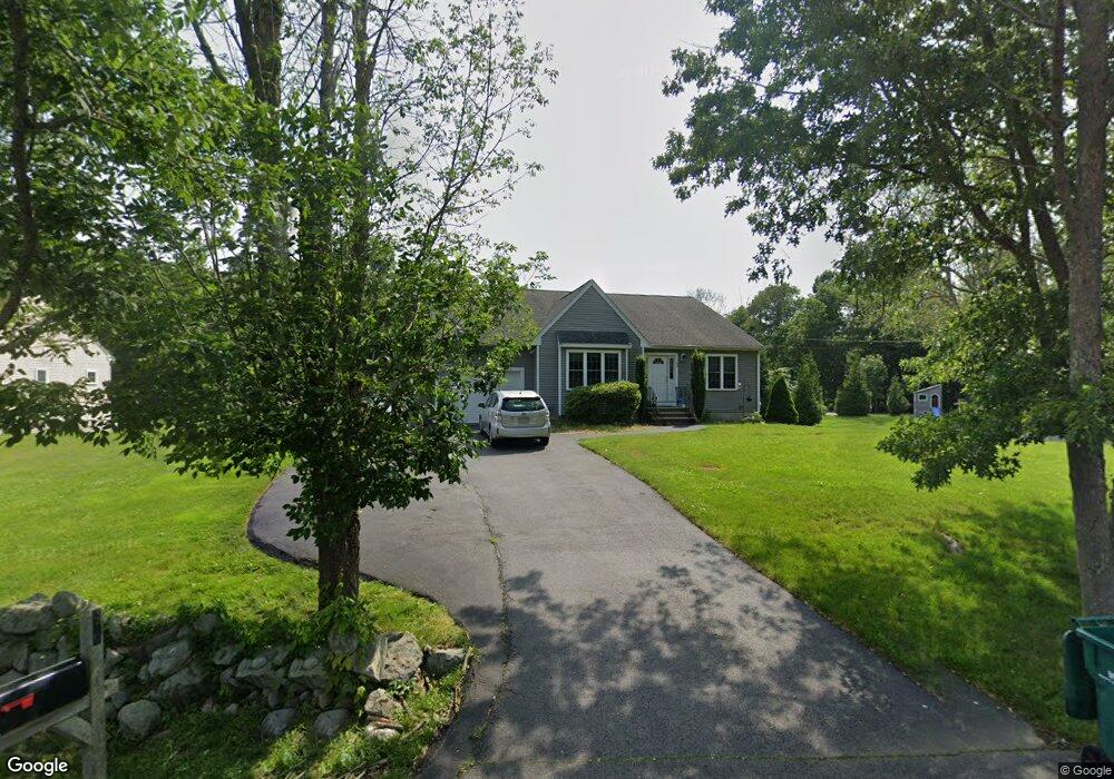
96 Canton St North Easton, MA 02356
Estimated Value: $660,000 - $777,000
4
Beds
3
Baths
2,800
Sq Ft
$261/Sq Ft
Est. Value
About This Home
This home is located at 96 Canton St, North Easton, MA 02356 and is currently estimated at $730,424, approximately $260 per square foot. 96 Canton St is a home located in Bristol County with nearby schools including Easton Middle School.
Ownership History
Date
Name
Owned For
Owner Type
Purchase Details
Closed on
May 31, 2023
Sold by
Mccarthy Keith T and Mccarthy Stephen
Bought by
Trabucco Nicholas and Trabucco Christa
Current Estimated Value
Home Financials for this Owner
Home Financials are based on the most recent Mortgage that was taken out on this home.
Original Mortgage
$532,000
Outstanding Balance
$516,637
Interest Rate
6.39%
Mortgage Type
Purchase Money Mortgage
Estimated Equity
$213,787
Purchase Details
Closed on
Mar 30, 2020
Sold by
Driver Harold D and Driver Jean M
Bought by
Mccarthy Keith T and Mccarthy Stephanie
Home Financials for this Owner
Home Financials are based on the most recent Mortgage that was taken out on this home.
Original Mortgage
$398,000
Interest Rate
3.4%
Mortgage Type
New Conventional
Purchase Details
Closed on
Mar 28, 2014
Sold by
Rivers Daniel
Bought by
Driver 4Th Harold D and Driver Jean M
Home Financials for this Owner
Home Financials are based on the most recent Mortgage that was taken out on this home.
Original Mortgage
$309,200
Interest Rate
4.27%
Mortgage Type
New Conventional
Purchase Details
Closed on
Sep 4, 2013
Sold by
Rivers Daniel and Rivers April
Bought by
Rivers Daniel
Purchase Details
Closed on
Oct 30, 2012
Sold by
Dkw Builders Inc
Bought by
Rivers Daniel and Rivers April
Purchase Details
Closed on
May 16, 2012
Sold by
Picker Field T and Picker Thomas
Bought by
Dkw Builders Inc
Purchase Details
Closed on
Apr 1, 2004
Sold by
Thomas James S
Bought by
Picker Field T and Picker Thomas
Create a Home Valuation Report for This Property
The Home Valuation Report is an in-depth analysis detailing your home's value as well as a comparison with similar homes in the area
Home Values in the Area
Average Home Value in this Area
Purchase History
| Date | Buyer | Sale Price | Title Company |
|---|---|---|---|
| Trabucco Nicholas | $675,000 | None Available | |
| Trabucco Nicholas | $675,000 | None Available | |
| Mccarthy Keith T | $497,500 | None Available | |
| Mccarthy Keith T | $497,500 | None Available | |
| Driver 4Th Harold D | $386,500 | -- | |
| Driver 4Th Harold D | $386,500 | -- | |
| Driver 4Th Harold D | $386,500 | -- | |
| Rivers Daniel | -- | -- | |
| Rivers Daniel | -- | -- | |
| Rivers Daniel | -- | -- | |
| Rivers Daniel | $370,000 | -- | |
| Rivers Daniel | $370,000 | -- | |
| Rivers Daniel | $370,000 | -- | |
| Dkw Builders Inc | $700,000 | -- | |
| Thomas James S | -- | -- | |
| Thomas James S | -- | -- | |
| Dkw Builders Inc | $700,000 | -- | |
| Thomas James S | -- | -- | |
| Picker Field T | -- | -- | |
| Picker Field T | -- | -- | |
| Picker Field T | -- | -- |
Source: Public Records
Mortgage History
| Date | Status | Borrower | Loan Amount |
|---|---|---|---|
| Open | Trabucco Nicholas | $532,000 | |
| Closed | Trabucco Nicholas | $532,000 | |
| Previous Owner | Mccarthy Keith T | $398,000 | |
| Previous Owner | Driver 4Th Harold D | $309,200 |
Source: Public Records
Tax History Compared to Growth
Tax History
| Year | Tax Paid | Tax Assessment Tax Assessment Total Assessment is a certain percentage of the fair market value that is determined by local assessors to be the total taxable value of land and additions on the property. | Land | Improvement |
|---|---|---|---|---|
| 2025 | $8,213 | $658,100 | $368,400 | $289,700 |
| 2024 | $8,547 | $640,200 | $347,500 | $292,700 |
| 2023 | $8,362 | $573,100 | $347,500 | $225,600 |
| 2022 | $7,807 | $507,300 | $283,700 | $223,600 |
| 2021 | $7,463 | $482,100 | $258,500 | $223,600 |
| 2020 | $7,198 | $468,000 | $248,600 | $219,400 |
| 2019 | $7,302 | $457,500 | $248,500 | $209,000 |
| 2018 | $7,219 | $442,100 | $248,500 | $193,600 |
| 2017 | $6,887 | $424,600 | $248,500 | $176,100 |
| 2016 | $6,769 | $418,100 | $248,600 | $169,500 |
| 2015 | $6,281 | $374,300 | $202,200 | $172,100 |
| 2014 | $6,169 | $370,500 | $205,000 | $165,500 |
Source: Public Records
Map
Nearby Homes
- 12 Holmes St
- 8 Hobart Way
- 15 King Ave
- 11 Olde Stable Ln
- 1 Whittier Ln Unit 1
- 18 Prudence Crandall Ln Unit 18
- 93 Palisades Cir
- 67 Center St
- 224 Main St
- 56 Williams St
- 225 Main St
- 1600 West St
- 32 Spooner St
- Lot 8 Cooper Ln
- 4 Eagle Rock Rd
- 334-336 Main St
- 280 Washington St
- 37 Kingsley Rd
- 14 Marshall Rd
- 45 Randall St
- 96 Canton St
- 96 Canton St Unit 1
- 96 Canton St Unit 2
- 96 Canton St Unit 5
- 92 Canton St
- 98 Canton St
- 100 Canton St
- 80 Canton St
- 72 Canton St
- 68 Canton St Unit 6
- 65 Canton St
- 64 Canton St
- 101 Canton St
- 105 Canton St
- 61 Canton St
- 57 Canton St
- 23 Vineyard Place
- 109 Canton St
- 109 Canton St Unit 1
- 113 Canton St