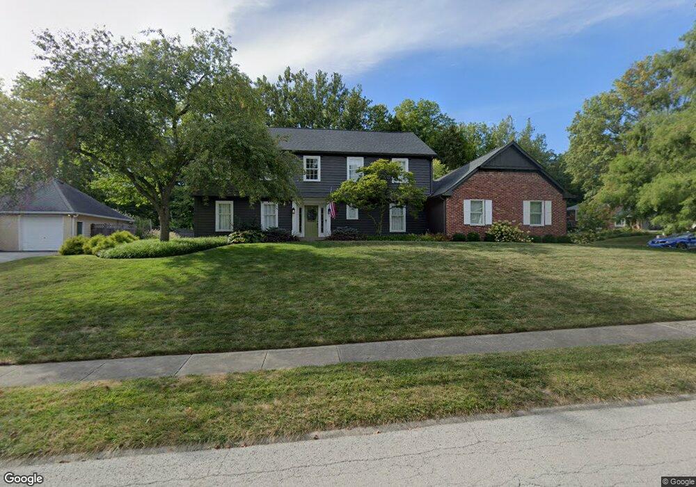
96 Red Oak Ln Carmel, IN 46033
East Carmel NeighborhoodEstimated Value: $570,000 - $698,270
4
Beds
4
Baths
4,516
Sq Ft
$143/Sq Ft
Est. Value
About This Home
This home is located at 96 Red Oak Ln, Carmel, IN 46033 and is currently estimated at $645,818, approximately $143 per square foot. 96 Red Oak Ln is a home located in Hamilton County with nearby schools including Mohawk Trails Elementary School, Clay Middle School, and Carmel High School.
Ownership History
Date
Name
Owned For
Owner Type
Purchase Details
Closed on
Dec 6, 2024
Sold by
Woodruff Matthew S and Woodruff Jamie S
Bought by
Matthew S Woodruff And Jamie S Woodruff Livin and Woodruff
Current Estimated Value
Purchase Details
Closed on
Sep 30, 2011
Sold by
Shaffer Beverly J and Shaffer Eugene C
Bought by
Woodruff Matthew S and Woodruff Jamie S
Home Financials for this Owner
Home Financials are based on the most recent Mortgage that was taken out on this home.
Original Mortgage
$287,100
Interest Rate
4.23%
Mortgage Type
New Conventional
Create a Home Valuation Report for This Property
The Home Valuation Report is an in-depth analysis detailing your home's value as well as a comparison with similar homes in the area
Home Values in the Area
Average Home Value in this Area
Purchase History
| Date | Buyer | Sale Price | Title Company |
|---|---|---|---|
| Matthew S Woodruff And Jamie S Woodruff Livin | -- | None Listed On Document | |
| Matthew S Woodruff And Jamie S Woodruff Livin | -- | None Listed On Document | |
| Woodruff Matthew S | -- | Chicago Title Insurance Co |
Source: Public Records
Mortgage History
| Date | Status | Borrower | Loan Amount |
|---|---|---|---|
| Previous Owner | Woodruff Matthew S | $287,100 |
Source: Public Records
Tax History Compared to Growth
Tax History
| Year | Tax Paid | Tax Assessment Tax Assessment Total Assessment is a certain percentage of the fair market value that is determined by local assessors to be the total taxable value of land and additions on the property. | Land | Improvement |
|---|---|---|---|---|
| 2024 | $7,105 | $644,400 | $128,700 | $515,700 |
| 2023 | $7,105 | $635,400 | $119,700 | $515,700 |
| 2022 | $5,493 | $481,900 | $119,700 | $362,200 |
| 2021 | $4,532 | $401,700 | $119,700 | $282,000 |
| 2020 | $4,026 | $357,600 | $119,700 | $237,900 |
| 2019 | $4,225 | $374,900 | $65,000 | $309,900 |
| 2018 | $3,875 | $350,400 | $65,000 | $285,400 |
| 2017 | $3,841 | $347,300 | $65,000 | $282,300 |
| 2016 | $3,664 | $336,600 | $65,000 | $271,600 |
| 2014 | $3,119 | $294,800 | $51,500 | $243,300 |
| 2013 | $3,119 | $280,600 | $51,500 | $229,100 |
Source: Public Records
Map
Nearby Homes
- 128 1st Ct
- 651 Hawthorne Dr
- 1129 Fairbanks Dr
- 13615 Smokey Hollow Place
- 781 Dayton Dr
- 728 E Main St
- 1303 E 126th St
- 131 Blairsden Ave
- 13233 Hazelwood Dr
- 423 Jenny Ln
- 12705 Brookshire Pkwy
- 428 Jenny Ln
- 12669 Brookshire Pkwy
- 3248 Smokey Ridge Way
- 3713 Coventry Way
- 542 Ash Dr
- 612 Ash Dr
- 1483 Spruce Dr
- 1983 Woodbine Ct
- 14011 Grisham Dr