Estimated Value: $979,000 - $1,819,000
3
Beds
2
Baths
3,584
Sq Ft
$383/Sq Ft
Est. Value
About This Home
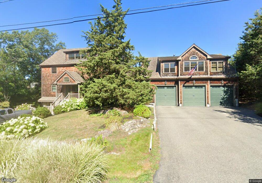
This home is located at 96 Rockaway Ave, Hull, MA 02045 and is currently estimated at $1,372,249, approximately $382 per square foot. 96 Rockaway Ave is a home located in Plymouth County with nearby schools including Lillian M. Jacobs Elementary School, Memorial Middle School, and Hull High School.
Ownership History
Date
Name
Owned For
Owner Type
Purchase Details
Closed on
May 17, 2017
Sold by
Bergamo John P and Bergamo Donna S
Bought by
Bergamo Rt and Bergamo
Current Estimated Value
Purchase Details
Closed on
Feb 8, 1991
Sold by
Santoro Eleanor A and Santoro Frank C
Bought by
Bergamo John P
Create a Home Valuation Report for This Property
The Home Valuation Report is an in-depth analysis detailing your home's value as well as a comparison with similar homes in the area
Home Values in the Area
Average Home Value in this Area
Purchase History
| Date | Buyer | Sale Price | Title Company |
|---|---|---|---|
| Bergamo Rt | -- | -- | |
| Bergamo John P | $175,000 | -- | |
| Bergamo John P | $175,000 | -- |
Source: Public Records
Mortgage History
| Date | Status | Borrower | Loan Amount |
|---|---|---|---|
| Previous Owner | Bergamo John P | $150,000 | |
| Previous Owner | Bergamo John P | $99,000 |
Source: Public Records
Tax History Compared to Growth
Tax History
| Year | Tax Paid | Tax Assessment Tax Assessment Total Assessment is a certain percentage of the fair market value that is determined by local assessors to be the total taxable value of land and additions on the property. | Land | Improvement |
|---|---|---|---|---|
| 2025 | $10,016 | $894,300 | $257,200 | $637,100 |
| 2024 | $9,944 | $853,600 | $249,700 | $603,900 |
| 2023 | $9,981 | $820,100 | $249,700 | $570,400 |
| 2022 | $9,958 | $794,100 | $249,700 | $544,400 |
| 2021 | $9,698 | $764,800 | $227,000 | $537,800 |
| 2020 | $9,252 | $721,700 | $219,400 | $502,300 |
| 2019 | $9,109 | $698,000 | $211,800 | $486,200 |
| 2018 | $0 | $632,500 | $211,800 | $420,700 |
| 2017 | $8,235 | $600,200 | $211,800 | $388,400 |
| 2016 | $8,296 | $615,400 | $227,000 | $388,400 |
| 2015 | $7,656 | $549,200 | $189,200 | $360,000 |
| 2014 | $7,617 | $549,200 | $189,200 | $360,000 |
Source: Public Records
Map
Nearby Homes
- 40 Rockaway Ave
- 23 Wyola Rd
- 15 Park Ave Unit 307
- 22 Berkley Rd Unit C
- 22 Berkley Rd Unit B
- 61 Barnstable Rd
- 19 Berkley Rd
- 4 Atherton Rd
- 155 Nantasket Ave Unit B402
- 120 Nantasket Ave Unit 304
- 120 Nantasket Ave Unit PH5
- 120 Nantasket Ave Unit 201
- 40 Oceanside Dr Unit 40
- 62 Oceanside Dr
- 25 Oceanside Dr
- 9 School St
- 7 Cliff Rd
- 6 State Park Rd Unit 2
- 67 Hampton Cir
- 1 Gatehouse Ln Unit 1
- 92 Rockaway Ave
- 97 Rockaway Ave
- 101 Rockaway Ave
- 90 Rockaway Ave
- 87 Rockaway Ave
- 26 Alsada Rd
- 155
- 9 Alsada Rd
- 28 Alsada Rd
- 14 Logan Ave
- 155 Geo Wash Blvd Unit 412
- 16 Logan Ave
- 155 George Washington Blvd Unit 508
- 155 George Washington Blvd Unit 406
- 155 George Washington Blvd Unit 212
- 155 George Washington Blvd Unit 501
- 155 George Washington Blvd Unit 201
- 155 George Washington Blvd Unit 214
- 155 George Washington Blvd Unit 504
- 155 George Washington Blvd Unit 407