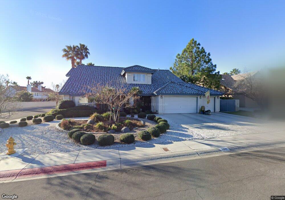
9601 Coral Way Las Vegas, NV 89117
The Section Seven NeighborhoodEstimated Value: $802,472 - $907,000
4
Beds
3
Baths
3,333
Sq Ft
$256/Sq Ft
Est. Value
About This Home
This home is located at 9601 Coral Way, Las Vegas, NV 89117 and is currently estimated at $853,118, approximately $255 per square foot. 9601 Coral Way is a home located in Clark County with nearby schools including M J Christensen Elementary School, Clifford J Lawrence Junior High School, and Bonanza High School.
Ownership History
Date
Name
Owned For
Owner Type
Purchase Details
Closed on
Dec 8, 1999
Sold by
Dale M Edwards Separate Property Trust
Bought by
Macdonald John A and Macdonald Holly
Current Estimated Value
Home Financials for this Owner
Home Financials are based on the most recent Mortgage that was taken out on this home.
Original Mortgage
$238,000
Outstanding Balance
$73,493
Interest Rate
7.68%
Estimated Equity
$779,625
Purchase Details
Closed on
Dec 24, 1998
Sold by
Edwards Dale M and Edwards Catherine L
Bought by
Edwards Dale M and Edwards Catherine L
Purchase Details
Closed on
Jul 11, 1997
Sold by
Edwards Dale and Edwards Dale M
Bought by
Edwards Dale M and Edwards Catherine L
Purchase Details
Closed on
Dec 7, 1994
Sold by
Edwards Dale
Bought by
Dale M Edwards Revocable Family Trust
Purchase Details
Closed on
Dec 2, 1994
Sold by
Edwards Jennifer
Bought by
Edwards Dale
Create a Home Valuation Report for This Property
The Home Valuation Report is an in-depth analysis detailing your home's value as well as a comparison with similar homes in the area
Home Values in the Area
Average Home Value in this Area
Purchase History
| Date | Buyer | Sale Price | Title Company |
|---|---|---|---|
| Macdonald John A | $312,000 | United Title | |
| Edwards Dale M | -- | -- | |
| Edwards Dale M | -- | First American Title Co | |
| Dale M Edwards Revocable Family Trust | -- | -- | |
| Edwards Dale | -- | -- |
Source: Public Records
Mortgage History
| Date | Status | Borrower | Loan Amount |
|---|---|---|---|
| Open | Macdonald John A | $238,000 |
Source: Public Records
Tax History Compared to Growth
Tax History
| Year | Tax Paid | Tax Assessment Tax Assessment Total Assessment is a certain percentage of the fair market value that is determined by local assessors to be the total taxable value of land and additions on the property. | Land | Improvement |
|---|---|---|---|---|
| 2025 | $3,781 | $186,306 | $75,950 | $110,356 |
| 2024 | $3,672 | $186,306 | $75,950 | $110,356 |
| 2023 | $3,672 | $168,414 | $62,300 | $106,114 |
| 2022 | $3,565 | $153,451 | $55,650 | $97,801 |
| 2021 | $3,461 | $140,132 | $46,200 | $93,932 |
| 2020 | $3,357 | $138,019 | $44,100 | $93,919 |
| 2019 | $3,260 | $131,726 | $38,500 | $93,226 |
| 2018 | $3,165 | $130,146 | $39,900 | $90,246 |
| 2017 | $4,133 | $126,062 | $33,950 | $92,112 |
| 2016 | $2,996 | $116,378 | $23,800 | $92,578 |
| 2015 | $2,991 | $100,596 | $23,800 | $76,796 |
| 2014 | $2,903 | $86,466 | $14,000 | $72,466 |
Source: Public Records
Map
Nearby Homes
- 9544 Lazy River Dr
- 9708 Blazing Star Ct
- 2728 Monrovia Dr
- 2724 Monrovia Dr
- 2729 Beachside Ct
- 9724 Cascade Falls Ave
- 9713 Cascade Falls Ave
- 9429 Abalone Way
- 3001 Bridge Creek St
- 9605 Blowing Sand Cir
- 3044 Forest Lake St
- 9624 Beach Water Cir
- 9548 Wooden Pier Way
- 9717 Sierra Mesa Ave
- 2913 Domino Way
- 3009 Periscope Ct
- 2821 Willow Wind Ct
- 9504 Cliff View Way
- 2300 Storkspur Way
- 2712 Quail Roost Way
- 9605 Coral Way
- 9600 Runaway Ct
- 9521 Coral Way
- 9604 Runaway Ct
- 9600 Coral Way
- 9604 Coral Way
- 9520 Treasure Beach Ct
- 9524 Coral Way
- 9517 Coral Way
- 9608 Runaway Ct Unit 1
- 9609 Coral Way
- 9516 Treasure Beach Ct
- 9612 Coral Way
- 9520 Coral Way
- 9608 Coral Way
- 9521 Treasure Beach Ct
- 9601 Runaway Ct
- 9513 Coral Way
- 9605 Runaway Ct
- 9512 Treasure Beach Ct