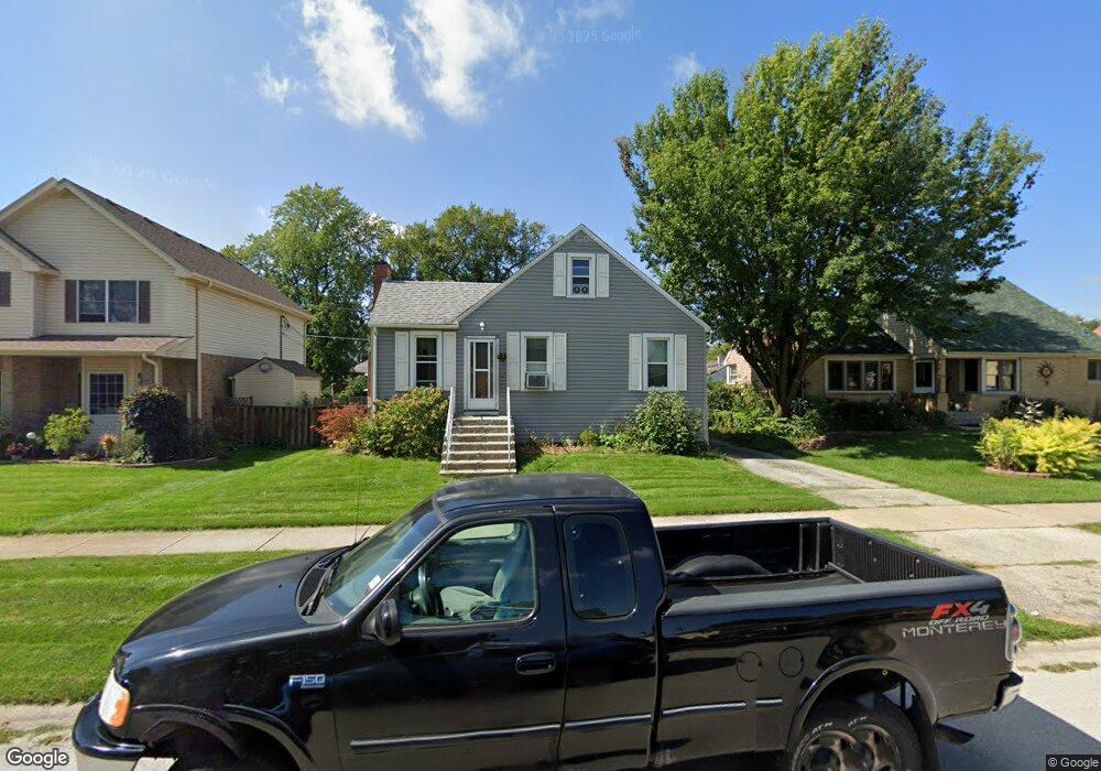
9606 Merrimac Ave Oak Lawn, IL 60453
Estimated Value: $221,404 - $306,000
3
Beds
1
Bath
1,534
Sq Ft
$168/Sq Ft
Est. Value
About This Home
This home is located at 9606 Merrimac Ave, Oak Lawn, IL 60453 and is currently estimated at $258,101, approximately $168 per square foot. 9606 Merrimac Ave is a home located in Cook County with nearby schools including Columbus Manor Elementary School, Simmons Middle School, and Oak Lawn Community High School.
Ownership History
Date
Name
Owned For
Owner Type
Purchase Details
Closed on
Jul 30, 2001
Sold by
Kummer Daniel
Bought by
Caliendo James J and Caliendo Denise D
Current Estimated Value
Home Financials for this Owner
Home Financials are based on the most recent Mortgage that was taken out on this home.
Original Mortgage
$141,550
Interest Rate
6.99%
Purchase Details
Closed on
Sep 6, 2000
Sold by
Radzienda Nancy
Bought by
Kummer Daniel
Home Financials for this Owner
Home Financials are based on the most recent Mortgage that was taken out on this home.
Original Mortgage
$128,700
Interest Rate
12.25%
Purchase Details
Closed on
Jul 15, 1995
Sold by
Radzienda Frank L and Radzienda Nancy
Bought by
Radzienda Nancy
Create a Home Valuation Report for This Property
The Home Valuation Report is an in-depth analysis detailing your home's value as well as a comparison with similar homes in the area
Home Values in the Area
Average Home Value in this Area
Purchase History
| Date | Buyer | Sale Price | Title Company |
|---|---|---|---|
| Caliendo James J | $149,000 | -- | |
| Kummer Daniel | $143,000 | -- | |
| Radzienda Nancy | -- | -- |
Source: Public Records
Mortgage History
| Date | Status | Borrower | Loan Amount |
|---|---|---|---|
| Previous Owner | Caliendo James J | $141,550 | |
| Previous Owner | Kummer Daniel | $128,700 |
Source: Public Records
Tax History Compared to Growth
Tax History
| Year | Tax Paid | Tax Assessment Tax Assessment Total Assessment is a certain percentage of the fair market value that is determined by local assessors to be the total taxable value of land and additions on the property. | Land | Improvement |
|---|---|---|---|---|
| 2024 | $1,200 | $4,463 | $2,829 | $1,634 |
| 2023 | $1,363 | $4,463 | $2,829 | $1,634 |
| 2022 | $1,363 | $4,226 | $2,425 | $1,801 |
| 2021 | $1,324 | $4,224 | $2,424 | $1,800 |
| 2020 | $1,305 | $4,224 | $2,424 | $1,800 |
| 2019 | $1,174 | $3,959 | $2,222 | $1,737 |
| 2018 | $1,125 | $3,959 | $2,222 | $1,737 |
| 2017 | $1,143 | $3,959 | $2,222 | $1,737 |
| 2016 | $998 | $3,223 | $1,818 | $1,405 |
| 2015 | $986 | $3,223 | $1,818 | $1,405 |
| 2014 | $979 | $3,223 | $1,818 | $1,405 |
| 2013 | $829 | $3,019 | $1,818 | $1,201 |
Source: Public Records
Map
Nearby Homes
- 9611 Merton Ave
- 9607 Marion Ave
- 9729 Merton Ave
- 9725 Ridgeland Ave Unit 1N
- 9714 Mcvicker Ave
- 9827 Melvina Ave
- 6237 W 94th St Unit 3S
- 9540 S Mayfield Ave Unit 103S
- 10005 Moody Ave
- 9912 Austin Ave
- 9520 S Mayfield Ave Unit N105
- 9725 Normandy Ave
- 6634 W 95th St Unit 1D
- 6632 W 95th St Unit 2C
- 9805 Normandy Ave
- 10030 Moody Ave
- 9258 Austin Ave
- 9808 Normandy Ave
- 10440 S Mayfield Ave Unit 1A
- 5810 W 97th St
- 9606 Merrimac Ave
- 9610 Merrimac Ave
- 9602 Merrimac Ave
- 9602 Merrimac Ave
- 9616 Merrimac Ave
- 9616 Merrimac Ave
- 9600 Merrimac Ave
- 9611 Merton Ave
- 9607 Merton Ave
- 9607 Merton Ave
- 9628 Merrimac Ave
- 9603 Merton Ave
- 9615 Merton Ave
- 9636 Merrimac Ave
- 9636 Merrimac Ave
- 9636 Merrimac Ave
- 9601 Merton Ave
- 9607 Merrimac Ave
- 9609 Merrimac Ave
- 9619 Merrimac Ave