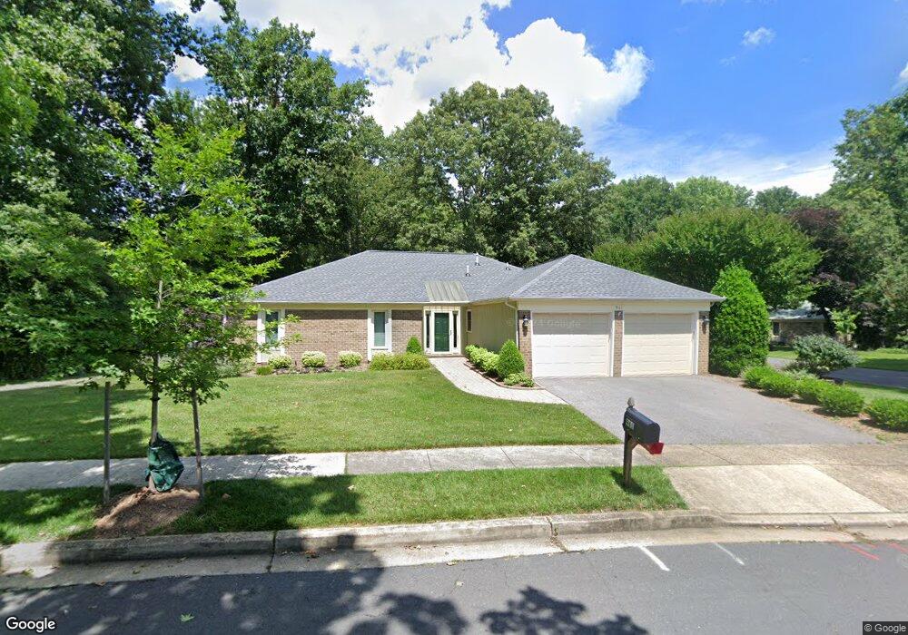
961 Running Brook Way Annapolis, MD 21401
Parole NeighborhoodEstimated Value: $650,000 - $695,000
3
Beds
2
Baths
1,836
Sq Ft
$363/Sq Ft
Est. Value
About This Home
This home is located at 961 Running Brook Way, Annapolis, MD 21401 and is currently estimated at $666,226, approximately $362 per square foot. 961 Running Brook Way is a home located in Anne Arundel County with nearby schools including Rolling Knolls Elementary School, Wiley H. Bates Middle School, and Annapolis High School.
Ownership History
Date
Name
Owned For
Owner Type
Purchase Details
Closed on
Apr 3, 2017
Sold by
Miloe Cherry
Bought by
The Cherry Miloe Trust
Current Estimated Value
Purchase Details
Closed on
Mar 25, 2008
Sold by
Keithley Marie E
Bought by
Underwood Roland H and Underwood Norma G
Purchase Details
Closed on
Mar 24, 2008
Sold by
Keithley Marie E
Bought by
Underwood Roland H and Underwood Norma G
Purchase Details
Closed on
Jun 13, 1997
Sold by
Keithley Marie E
Bought by
Keithley Marie E and Keithley Steven W
Create a Home Valuation Report for This Property
The Home Valuation Report is an in-depth analysis detailing your home's value as well as a comparison with similar homes in the area
Home Values in the Area
Average Home Value in this Area
Purchase History
| Date | Buyer | Sale Price | Title Company |
|---|---|---|---|
| The Cherry Miloe Trust | -- | None Available | |
| Underwood Roland H | $405,000 | -- | |
| Underwood Roland H | $405,000 | -- | |
| Keithley Marie E | -- | -- |
Source: Public Records
Tax History Compared to Growth
Tax History
| Year | Tax Paid | Tax Assessment Tax Assessment Total Assessment is a certain percentage of the fair market value that is determined by local assessors to be the total taxable value of land and additions on the property. | Land | Improvement |
|---|---|---|---|---|
| 2025 | $5,002 | $491,967 | -- | -- |
| 2024 | $5,002 | $459,233 | $0 | $0 |
| 2023 | $4,847 | $426,500 | $227,300 | $199,200 |
| 2022 | $4,544 | $426,500 | $227,300 | $199,200 |
| 2021 | $8,945 | $426,500 | $227,300 | $199,200 |
| 2020 | $4,373 | $434,800 | $237,300 | $197,500 |
| 2019 | $4,283 | $412,967 | $0 | $0 |
| 2018 | $3,966 | $391,133 | $0 | $0 |
| 2017 | $3,998 | $369,300 | $0 | $0 |
| 2016 | -- | $357,067 | $0 | $0 |
| 2015 | -- | $344,833 | $0 | $0 |
| 2014 | -- | $332,600 | $0 | $0 |
Source: Public Records
Map
Nearby Homes
- 1007 Boom Ct
- 916 Sextant Way
- 1012 Mastline Dr
- 1003 Mastline Dr
- 1909 Marconi Cir
- 2671 Cunningham Hole Rd
- 2600 Compass Dr
- 932 Riversedge Cir
- 2601 Compass Dr
- 2664 Compass Dr
- 940 Astern Way Unit 604
- 940 Astern Way Unit 309
- 2737 Yeomans Lantern Ct
- 930 Astern Way Unit 609
- 930 Astern Way Unit 502
- 930 Astern Way Unit 405
- 930 Astern Way Unit 511
- 772 Ballast Way
- 2900 Shipmaster Way Unit 216
- 2900 Shipmaster Way Unit 211
- 925 Schooner Cir
- 963 Running Brook Way
- 967 Running Brook Way
- 960 Running Brook Way
- 923 Schooner Cir
- 965 Running Brook Way
- 962 Running Brook Way
- 922 Schooner Cir
- 926 Schooner Cir
- 969 Running Brook Way
- 964 Running Brook Way
- 921 Schooner Cir
- 928 Schooner Cir
- 920 Schooner Cir
- 959 Shadewater Way
- 930 Schooner Cir
- 966 Running Brook Way
- 971 Running Brook Way
- 961 Shadewater Way
- 919 Schooner Cir