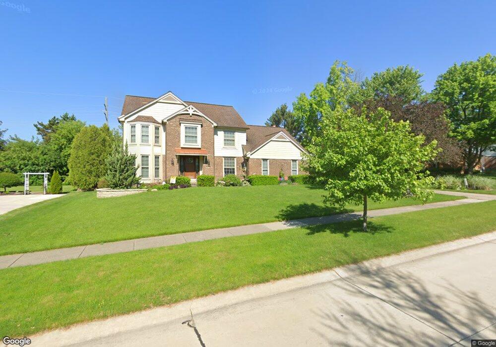
9611 Red Maple Dr Plymouth, MI 48170
Estimated Value: $575,000 - $619,000
4
Beds
3
Baths
2,421
Sq Ft
$247/Sq Ft
Est. Value
About This Home
This home is located at 9611 Red Maple Dr, Plymouth, MI 48170 and is currently estimated at $599,187, approximately $247 per square foot. 9611 Red Maple Dr is a home located in Wayne County with nearby schools including Canton High School, Isbister Elementary School, and Salem High School.
Ownership History
Date
Name
Owned For
Owner Type
Purchase Details
Closed on
Dec 21, 2017
Sold by
Asher Judy and Asher Judy A
Bought by
Asher Roy A
Current Estimated Value
Purchase Details
Closed on
Mar 31, 2011
Sold by
Freeman Nathan and Freeman Laura
Bought by
Asher Judy A
Purchase Details
Closed on
Nov 12, 2004
Sold by
National Residential Nominee Svcs Inc
Bought by
Freeman Nathan
Purchase Details
Closed on
Apr 3, 1998
Sold by
Bedrosian Daniel S
Bought by
Miera Debra S
Create a Home Valuation Report for This Property
The Home Valuation Report is an in-depth analysis detailing your home's value as well as a comparison with similar homes in the area
Home Values in the Area
Average Home Value in this Area
Purchase History
| Date | Buyer | Sale Price | Title Company |
|---|---|---|---|
| Asher Roy A | -- | None Available | |
| Asher Judy A | $295,000 | Liberty Title | |
| Freeman Nathan | $314,000 | First American Title Se Div | |
| National Residential Nominee Svcs Inc | $314,000 | First American Title Se Div | |
| Miera Debra S | $252,900 | -- |
Source: Public Records
Tax History Compared to Growth
Tax History
| Year | Tax Paid | Tax Assessment Tax Assessment Total Assessment is a certain percentage of the fair market value that is determined by local assessors to be the total taxable value of land and additions on the property. | Land | Improvement |
|---|---|---|---|---|
| 2025 | $4,282 | $265,200 | $0 | $0 |
| 2024 | $4,282 | $248,700 | $0 | $0 |
| 2023 | $4,080 | $214,400 | $0 | $0 |
| 2022 | $5,426 | $203,600 | $0 | $0 |
| 2021 | $5,264 | $201,300 | $0 | $0 |
| 2019 | $5,107 | $182,960 | $0 | $0 |
| 2018 | $3,491 | $178,640 | $0 | $0 |
| 2017 | $2,439 | $40,600 | $0 | $0 |
| 2016 | $4,794 | $172,500 | $0 | $0 |
| 2015 | $14,618 | $172,280 | $0 | $0 |
| 2013 | $14,162 | $151,340 | $0 | $0 |
| 2012 | -- | $138,310 | $35,490 | $102,820 |
Source: Public Records
Map
Nearby Homes
- 9377 Pineview Dr
- 9079 Woodgrove Dr
- 49238 Plum Tree Dr
- 50157 E Fellows Creek Ct
- 9875 Ann Arbor Trail
- 9350 Colony Farms Ct
- 0 E Ann Arbor Trail Unit 20251048195
- 48100 Powell Rd
- 48814 Gyde Rd
- 9421 Mapletree Dr
- 11641 Chandler Dr
- 11809 Amherst Ct
- 7809 Haverhill Ct N
- 1526 Hickory Ridge Ct S
- 11431 Sandalwood Dr
- 0 N Beck Rd
- 8140 N Pointe Ct
- 48441 N Territorial Rd
- 4745 Napier Ct
- 47472 Verona Ct
- 9645 Red Maple Dr
- 9567 Red Maple Dr
- 9610 Red Maple Dr
- 9535 Red Maple Dr
- 9677 Red Maple Dr
- 9630 Red Maple Dr
- 9566 Red Maple Dr
- 9650 Red Maple Dr
- 9545 N Ridge Rd
- 9501 Red Maple Dr
- 9637 Winterset Cir
- 9700 Red Maple Dr
- 9653 Winterset Cir
- 9669 Winterset Cir
- 49333 Woodway Dr
- 9763 Red Maple Dr
- 9470 Pineview Dr
- 9621 Winterset Cir
- 9475 Red Maple Dr
- 9740 Red Maple Dr