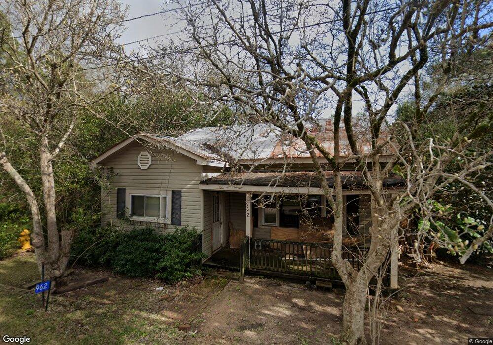
962 Summitt Dr NE Dawson, GA 39842
Estimated Value: $73,000 - $104,000
3
Beds
1
Bath
1,243
Sq Ft
$67/Sq Ft
Est. Value
About This Home
This home is located at 962 Summitt Dr NE, Dawson, GA 39842 and is currently estimated at $83,667, approximately $67 per square foot. 962 Summitt Dr NE is a home located in Terrell County with nearby schools including Cooper-Carver Elementary School, Terrell Middle School, and Terrell High School.
Ownership History
Date
Name
Owned For
Owner Type
Purchase Details
Closed on
Jan 15, 2021
Sold by
Brown Joe
Bought by
Darity Latasha Ann and Cody Jermaine Theron
Current Estimated Value
Purchase Details
Closed on
Mar 27, 2020
Sold by
Parnacott Owen W
Bought by
Brown Joe and Brown Mildred
Purchase Details
Closed on
Jul 12, 2018
Sold by
Bank Of Dawson
Bought by
Parnacott Owen W
Purchase Details
Closed on
Nov 11, 2016
Sold by
Joe
Bought by
Bank Of Dawson
Purchase Details
Closed on
Oct 14, 2004
Sold by
Brown Joe
Bought by
Brown Joe and Mildred Lee
Purchase Details
Closed on
Sep 12, 2003
Sold by
Patterson Theron
Bought by
Brown Joe
Create a Home Valuation Report for This Property
The Home Valuation Report is an in-depth analysis detailing your home's value as well as a comparison with similar homes in the area
Home Values in the Area
Average Home Value in this Area
Purchase History
| Date | Buyer | Sale Price | Title Company |
|---|---|---|---|
| Darity Latasha Ann | -- | -- | |
| Brown Joe | -- | -- | |
| Parnacott Owen W | $770 | -- | |
| Bank Of Dawson | -- | -- | |
| Brown Joe | -- | -- | |
| Brown Joe | $16,000 | -- |
Source: Public Records
Tax History Compared to Growth
Tax History
| Year | Tax Paid | Tax Assessment Tax Assessment Total Assessment is a certain percentage of the fair market value that is determined by local assessors to be the total taxable value of land and additions on the property. | Land | Improvement |
|---|---|---|---|---|
| 2024 | $269 | $8,690 | $2,880 | $5,810 |
| 2023 | $269 | $8,690 | $2,880 | $5,810 |
| 2022 | $269 | $8,690 | $2,880 | $5,810 |
| 2021 | $269 | $8,690 | $2,880 | $5,810 |
| 2020 | $269 | $8,690 | $2,880 | $5,810 |
| 2019 | $261 | $8,690 | $2,880 | $5,810 |
| 2018 | $261 | $8,690 | $2,880 | $5,810 |
| 2017 | $261 | $8,690 | $2,880 | $5,810 |
| 2016 | $201 | $8,690 | $2,880 | $5,810 |
| 2015 | -- | $8,690 | $2,880 | $5,810 |
| 2014 | -- | $8,690 | $2,880 | $5,810 |
| 2013 | -- | $8,690 | $2,880 | $5,810 |
Source: Public Records
Map
Nearby Homes
- 0 Cooper Dr NE Unit 7597500
- 0 Cooper Dr NE Unit 10543060
- 904 Ash St NE
- 1264 Ball Park Ave NE
- 1256 Ball Park Ave NE
- 1239 Askew Dr NE
- 711 Pineview Ln NE
- 1240 Askew Dr NE
- 1258 Askew Dr NE
- 1291 Askew Dr NE
- 1148 Ball Park Ave NE
- 513 College St NE
- 509 Orange St NE
- 526 7th Ave NE
- 448 Henry Mitchell Dr NE
- 787 E Lee St
- 707 Johnson St SE
- 411 E Lee St
- 615 Johnson St SE
- 361/552 NW Tenth Ave
- 970 Summitt Dr NE
- 954 Summitt Dr NE
- 953 Summitt Dr NE Unit 961
- 971 Summitt Dr NE
- 976 Summitt Dr NE
- 946 Summitt Dr NE
- 947 Summitt Dr NE
- 987 Summitt Dr NE
- 1111 Bronwood Hwy Unit 1115
- 939 Summitt Dr NE
- 990 Summitt Dr NE
- 993 Summitt Dr NE
- 933 Summitt Dr NE
- 936A Summitt Dr NE Unit B
- 1014 Summitt Dr NE
- 1001 Summitt Dr NE
- 1072 Flint St NE
- 926 Summitt Dr NE
- 622 15th Ave NE
- 1056 Flint St NE