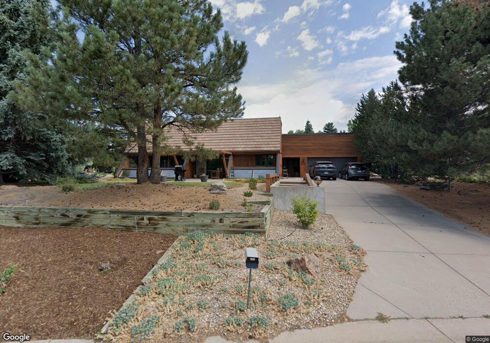
9629 E Powers Place Greenwood Village, CO 80111
Denver Tech Center NeighborhoodEstimated Value: $1,472,704 - $1,829,000
3
Beds
2
Baths
4,437
Sq Ft
$379/Sq Ft
Est. Value
About This Home
This home is located at 9629 E Powers Place, Greenwood Village, CO 80111 and is currently estimated at $1,680,176, approximately $378 per square foot. 9629 E Powers Place is a home located in Arapahoe County with nearby schools including Belleview Elementary School, Campus Middle School, and Cherry Creek High School.
Ownership History
Date
Name
Owned For
Owner Type
Purchase Details
Closed on
Dec 15, 2016
Sold by
Whitaker Philip S
Bought by
Coleman Christopher D and Coleman Mehran Laleh
Current Estimated Value
Home Financials for this Owner
Home Financials are based on the most recent Mortgage that was taken out on this home.
Original Mortgage
$679,200
Outstanding Balance
$548,780
Interest Rate
3.54%
Mortgage Type
New Conventional
Estimated Equity
$1,131,396
Purchase Details
Closed on
Jul 4, 1776
Bought by
Conversion Arapco
Create a Home Valuation Report for This Property
The Home Valuation Report is an in-depth analysis detailing your home's value as well as a comparison with similar homes in the area
Home Values in the Area
Average Home Value in this Area
Purchase History
| Date | Buyer | Sale Price | Title Company |
|---|---|---|---|
| Coleman Christopher D | $849,000 | None Available | |
| Conversion Arapco | -- | -- |
Source: Public Records
Mortgage History
| Date | Status | Borrower | Loan Amount |
|---|---|---|---|
| Open | Coleman Christopher D | $679,200 |
Source: Public Records
Tax History Compared to Growth
Tax History
| Year | Tax Paid | Tax Assessment Tax Assessment Total Assessment is a certain percentage of the fair market value that is determined by local assessors to be the total taxable value of land and additions on the property. | Land | Improvement |
|---|---|---|---|---|
| 2024 | $7,935 | $98,544 | -- | -- |
| 2023 | $7,935 | $98,544 | $0 | $0 |
| 2022 | $5,777 | $67,763 | $0 | $0 |
| 2021 | $5,810 | $67,763 | $0 | $0 |
| 2020 | $6,060 | $71,930 | $0 | $0 |
| 2019 | $5,818 | $71,930 | $0 | $0 |
| 2018 | $4,737 | $55,066 | $0 | $0 |
| 2017 | $4,678 | $55,066 | $0 | $0 |
| 2016 | $4,136 | $54,438 | $0 | $0 |
| 2015 | $3,965 | $54,438 | $0 | $0 |
| 2014 | -- | $47,911 | $0 | $0 |
| 2013 | -- | $40,780 | $0 | $0 |
Source: Public Records
Map
Nearby Homes
- 5441 S Clinton Ct
- 9649 E Powers Dr
- 9500 Poundstone Place
- 9697 E Powers Dr
- 9505 Poundstone Place
- 5442 S Dayton Ct
- 5420 S Berry Ln
- 5643 S Fulton Way
- 5735 Big Canon Dr
- 5755 S Fulton Way
- 5775 Big Canon Dr
- 9931 E Ida Place
- 17 Canon Dr
- 5240 S Beeler Ct
- 10289 E Berry Dr
- 56 Coral Place
- 5672 S Hanover Way
- 5677 S Park Place Unit A308
- 5677 S Park Place Unit B111
- 5677 S Park Place Unit B206
- 5440 S Clinton Ct
- 5421 S Dallas St
- 9630 E Powers Place
- 5421 S Clinton Ct
- 9650 E Powers Place
- 5420 S Clinton Ct
- 5401 S Dallas St
- 9560 E Powers Place
- 5411 S Clinton Ct
- 5450 S Chester Ct
- 5430 S Chester Ct
- 9535 E Powers Place
- 5450 S Dallas St
- 5470 S Dallas St
- 5410 S Chester Ct
- 5430 S Dallas St
- 5490 S Dallas St
- 9628 E Powers Dr
- 9520 E Powers Place
- 9444 Poundstone Place