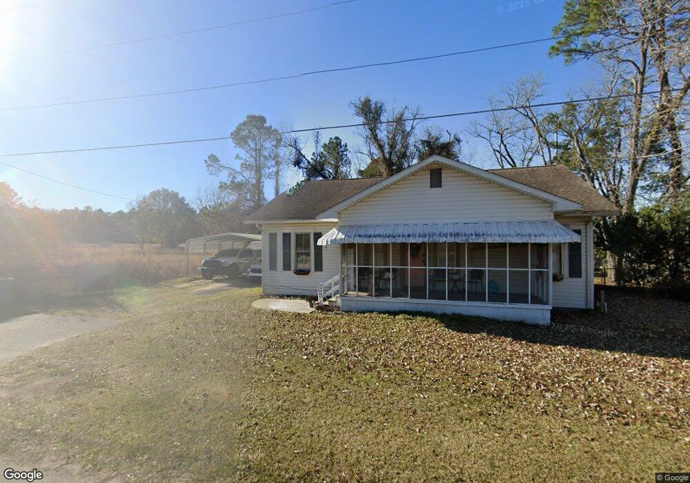
9629 Main St S Nahunta, GA 31553
Estimated Value: $91,000 - $187,000
Studio
--
Bath
1,960
Sq Ft
$74/Sq Ft
Est. Value
About This Home
This home is located at 9629 Main St S, Nahunta, GA 31553 and is currently estimated at $145,950, approximately $74 per square foot. 9629 Main St S is a home with nearby schools including Nahunta Primary School, Nahunta Elementary School, and Brantley County Middle School.
Ownership History
Date
Name
Owned For
Owner Type
Purchase Details
Closed on
Feb 4, 2024
Sold by
Curry Devin Earl
Bought by
Curry Devin and Curry Kaytlin
Current Estimated Value
Home Financials for this Owner
Home Financials are based on the most recent Mortgage that was taken out on this home.
Original Mortgage
$109,890
Outstanding Balance
$107,407
Interest Rate
6.62%
Mortgage Type
FHA
Estimated Equity
$38,543
Purchase Details
Closed on
Jun 18, 2018
Sold by
Griner Donald Hubert
Bought by
Curry Devin Earl
Home Financials for this Owner
Home Financials are based on the most recent Mortgage that was taken out on this home.
Original Mortgage
$77,000
Interest Rate
4.6%
Mortgage Type
New Conventional
Create a Home Valuation Report for This Property
The Home Valuation Report is an in-depth analysis detailing your home's value as well as a comparison with similar homes in the area
Purchase History
| Date | Buyer | Sale Price | Title Company |
|---|---|---|---|
| Curry Devin | -- | -- | |
| Curry Devin Earl | $80,000 | -- |
Source: Public Records
Mortgage History
| Date | Status | Borrower | Loan Amount |
|---|---|---|---|
| Open | Curry Devin | $109,890 | |
| Previous Owner | Curry Devin Earl | $77,000 |
Source: Public Records
Tax History
| Year | Tax Paid | Tax Assessment Tax Assessment Total Assessment is a certain percentage of the fair market value that is determined by local assessors to be the total taxable value of land and additions on the property. | Land | Improvement |
|---|---|---|---|---|
| 2025 | $1,709 | $48,819 | $5,320 | $43,499 |
| 2024 | $1,490 | $37,076 | $3,600 | $33,476 |
| 2023 | $1,507 | $37,076 | $3,600 | $33,476 |
| 2022 | $1,507 | $37,076 | $3,600 | $33,476 |
| 2021 | $1,454 | $29,639 | $3,600 | $26,039 |
| 2020 | $1,462 | $29,639 | $3,600 | $26,039 |
| 2019 | $1,512 | $29,639 | $3,600 | $26,039 |
| 2018 | $1,413 | $29,639 | $3,600 | $26,039 |
| 2017 | $1,413 | $29,639 | $3,600 | $26,039 |
| 2016 | $906 | $29,639 | $3,600 | $26,039 |
| 2015 | -- | $29,639 | $3,600 | $26,039 |
Source: Public Records
Map
Nearby Homes
- 20.55 ACRES Highway 82
- 92 Ervin St
- 154 Avalon St
- 440 Brantley St
- 109 Rainge St
- 387 Burton St
- 584 Knox St
- 00 Robin Ln
- 828 Knox St
- 4561 Buffalo Creek Dr
- 29 Chisholm St
- 7126 U S 301
- 1473 Chesser Ln
- 4432 Pembers Rd
- 537 Seward Trail
- 4452 Pembers Rd
- 193 Blackberry Rd
- 3362 Seed Orchard Rd
- 91 Cane Cir
- 0 Sylvester Dr Unit 10674962
- 0 Satilla Ave
- 9606 Main St S
- 9667 Main St S
- 0 Howard St Unit 7235135
- 0 Howard St Unit 7055064
- 0 Howard St Unit 3175265
- 0 Howard St Unit 7235154
- 9590 Main St S
- 1 Howard St
- 104 S Main St
- 106 James St
- 0 S Main St
- 121 Cannon St
- 255 Cannon St
- 115 Cannon St
- 19 Us Highway 82 Hwy
- 19 Hwy 82
- 401 Plum St
- Tract 1 Dewey Rd
- Tract 1 None
Your Personal Tour Guide
Ask me questions while you tour the home.