Estimated Value: $253,781 - $265,000
3
Beds
2
Baths
1,176
Sq Ft
$219/Sq Ft
Est. Value
About This Home
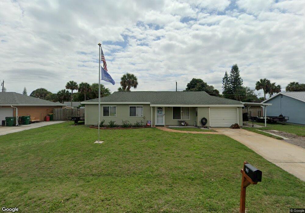
This home is located at 965 Eyerly St, Cocoa, FL 32927 and is currently estimated at $257,945, approximately $219 per square foot. 965 Eyerly St is a home located in Brevard County with nearby schools including Atlantis Elementary School, Space Coast Junior/Senior High School, and East Atlantic Prep of Brevard County.
Ownership History
Date
Name
Owned For
Owner Type
Purchase Details
Closed on
May 27, 1995
Sold by
Tancreti Roger J and Tancreti Mary F
Bought by
Prather David D and Prather Pamela A
Current Estimated Value
Home Financials for this Owner
Home Financials are based on the most recent Mortgage that was taken out on this home.
Original Mortgage
$46,975
Interest Rate
8.22%
Create a Home Valuation Report for This Property
The Home Valuation Report is an in-depth analysis detailing your home's value as well as a comparison with similar homes in the area
Home Values in the Area
Average Home Value in this Area
Purchase History
| Date | Buyer | Sale Price | Title Company |
|---|---|---|---|
| Prather David D | $47,000 | -- |
Source: Public Records
Mortgage History
| Date | Status | Borrower | Loan Amount |
|---|---|---|---|
| Closed | Prather David D | $46,975 |
Source: Public Records
Tax History Compared to Growth
Tax History
| Year | Tax Paid | Tax Assessment Tax Assessment Total Assessment is a certain percentage of the fair market value that is determined by local assessors to be the total taxable value of land and additions on the property. | Land | Improvement |
|---|---|---|---|---|
| 2025 | $906 | $57,870 | -- | -- |
| 2024 | $888 | $53,810 | -- | -- |
| 2023 | $888 | $52,250 | $0 | $0 |
| 2022 | $851 | $50,730 | $0 | $0 |
| 2021 | $844 | $49,260 | $0 | $0 |
| 2020 | $793 | $48,580 | $0 | $0 |
| 2019 | $731 | $47,490 | $0 | $0 |
| 2018 | $723 | $46,610 | $0 | $0 |
| 2017 | $712 | $45,660 | $0 | $0 |
| 2016 | $705 | $44,730 | $18,000 | $26,730 |
| 2015 | $702 | $44,420 | $15,000 | $29,420 |
| 2014 | $702 | $44,070 | $11,000 | $33,070 |
Source: Public Records
Map
Nearby Homes
- 219 Fecco St
- 208 Capron Rd
- 7420 U S Route 1 Unit 106
- 000 Arabella Ln
- 7350 N Highway 1 Unit 201
- 7330 N Highway 1 Unit 206
- 7300 N Highway 1 Unit 204
- 7300 N Highway 1 Unit 104
- 361 Payne Ave
- 0 Kanawha St
- 7420 N Highway 1 Unit 203
- 7450 N Highway 1 Unit 205
- 7400 N Highway 1 Unit 105
- 7470 N Highway 1 Unit 105
- 977 Poinsetta St
- 846 W Virginia St
- 973 Poinsetta St
- 7240 N Highway 1 Unit 106
- 7170 N Highway 1 Unit 103
- 7210 N Highway 1 Unit 102