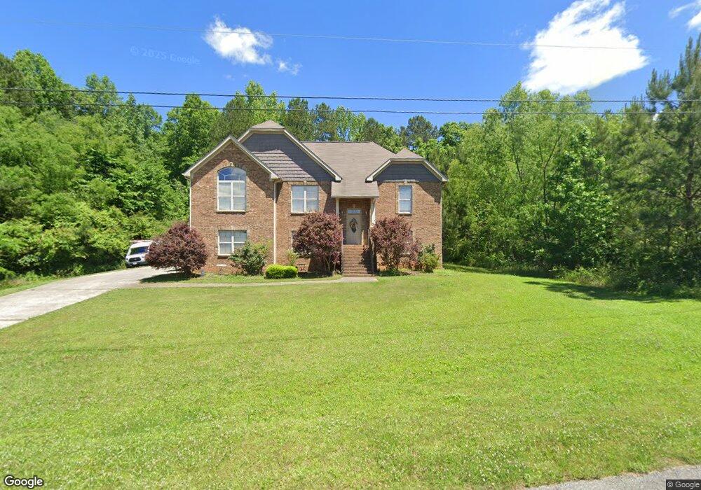
965 Moonlite Dr Odenville, AL 35120
Estimated Value: $246,000 - $268,000
--
Bed
2
Baths
1,622
Sq Ft
$159/Sq Ft
Est. Value
About This Home
This home is located at 965 Moonlite Dr, Odenville, AL 35120 and is currently estimated at $258,085, approximately $159 per square foot. 965 Moonlite Dr is a home located in St. Clair County with nearby schools including Margaret Elementary School, Moody Middle School, and Moody High School.
Ownership History
Date
Name
Owned For
Owner Type
Purchase Details
Closed on
Apr 18, 2008
Sold by
Kennedy Billy and Wood Jason
Bought by
Hayes Jeff W and Hayes Julie R
Current Estimated Value
Home Financials for this Owner
Home Financials are based on the most recent Mortgage that was taken out on this home.
Original Mortgage
$168,518
Outstanding Balance
$106,023
Interest Rate
5.84%
Mortgage Type
FHA
Estimated Equity
$152,062
Purchase Details
Closed on
Oct 9, 2007
Sold by
A & D Builders Llc
Bought by
Kennedy Billy and Woods Jason
Create a Home Valuation Report for This Property
The Home Valuation Report is an in-depth analysis detailing your home's value as well as a comparison with similar homes in the area
Home Values in the Area
Average Home Value in this Area
Purchase History
| Date | Buyer | Sale Price | Title Company |
|---|---|---|---|
| Hayes Jeff W | $169,850 | None Available | |
| Kennedy Billy | -- | None Available |
Source: Public Records
Mortgage History
| Date | Status | Borrower | Loan Amount |
|---|---|---|---|
| Open | Hayes Jeff W | $168,518 |
Source: Public Records
Tax History Compared to Growth
Tax History
| Year | Tax Paid | Tax Assessment Tax Assessment Total Assessment is a certain percentage of the fair market value that is determined by local assessors to be the total taxable value of land and additions on the property. | Land | Improvement |
|---|---|---|---|---|
| 2024 | $805 | $47,370 | $6,400 | $40,970 |
| 2023 | $805 | $39,832 | $6,400 | $33,432 |
| 2022 | $669 | $19,916 | $3,200 | $16,716 |
| 2021 | $670 | $19,916 | $3,200 | $16,716 |
| 2020 | $670 | $19,918 | $3,200 | $16,718 |
| 2019 | $645 | $19,218 | $2,500 | $16,718 |
| 2018 | $574 | $17,280 | $0 | $0 |
| 2017 | $571 | $17,280 | $0 | $0 |
| 2016 | $574 | $17,280 | $0 | $0 |
| 2015 | $571 | $17,280 | $0 | $0 |
| 2014 | $571 | $17,200 | $0 | $0 |
Source: Public Records
Map
Nearby Homes
- 925 Moonlite Dr
- 890 Moonlite Dr
- 0 Railroad Dr Unit 22741747
- 55 Rae St
- 457 Hidden Ridge Dr
- 560 Ridge Cir
- 2590 Levine Rd
- 195 Sanie Cove Ln
- 190 Sanie Cove Ln
- 200 Sanie Cove Ln
- 210 Sanie Cove Ln
- 220 Sanie Cove Ln
- 205 Sanie Cove Ln
- 230 Sanie Cove Ln
- 204 Morgan Brown Rd
- 540 Applewood Ln Unit 28
- 116 Solar Shield Blvd
- 956 Blue Ridge Way
- 10 Field Ln
- 0 Clearview Rd Unit 21424571
- 965 Moonlite Dr Unit 705
- 955 Moonlite Dr Unit 704
- 985 Moonlite Dr
- 985 Moonlite Dr Unit 707
- 960 Moonlite Dr
- 985 Moonlite Dr
- 940 Moonlite Dr
- 945 Moonlite Dr
- 945 Moonlite Dr Unit 703
- 980 Moonlite Dr
- 935 Moonlite Dr Unit 702
- 935 Moonlite Dr
- 995 Moonlite Dr Unit 708
- 995 Moonlite Dr
- 920 Moonlite Dr
- 920 Moonlite Dr
- 920 Moonlite Dr Unit 809
- 65 Starlite Cir
- 925 Moonlite Dr Unit 701