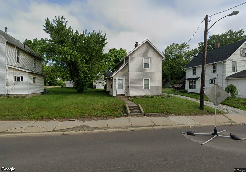
966 Wooster Rd N Barberton, OH 44203
North Barberton NeighborhoodEstimated Value: $136,000 - $147,000
3
Beds
1
Bath
1,344
Sq Ft
$106/Sq Ft
Est. Value
About This Home
This home is located at 966 Wooster Rd N, Barberton, OH 44203 and is currently estimated at $142,409, approximately $105 per square foot. 966 Wooster Rd N is a home located in Summit County with nearby schools including Barberton Middle School, Barberton Intermediate School 3-5, and Barberton High School.
Ownership History
Date
Name
Owned For
Owner Type
Purchase Details
Closed on
Dec 3, 2018
Sold by
Bonk Jeffrey A and Bonk Sheryl A
Bought by
Chc Properties Llc
Current Estimated Value
Purchase Details
Closed on
Aug 16, 2013
Sold by
Bonk Christine M
Bought by
Bonk Jeffrey S
Purchase Details
Closed on
Jun 19, 2000
Sold by
Koncz Donald
Bought by
Bonk Jeffrey A and Bonk Sheryl A
Purchase Details
Closed on
May 11, 2000
Sold by
Dodd James R
Bought by
Koncz Donald
Create a Home Valuation Report for This Property
The Home Valuation Report is an in-depth analysis detailing your home's value as well as a comparison with similar homes in the area
Home Values in the Area
Average Home Value in this Area
Purchase History
| Date | Buyer | Sale Price | Title Company |
|---|---|---|---|
| Chc Properties Llc | -- | None Available | |
| Bonk Jeffrey S | -- | None Available | |
| Bonk Jeffrey A | $47,450 | Midland Commerce Group | |
| Koncz Donald | $40,000 | -- |
Source: Public Records
Tax History Compared to Growth
Tax History
| Year | Tax Paid | Tax Assessment Tax Assessment Total Assessment is a certain percentage of the fair market value that is determined by local assessors to be the total taxable value of land and additions on the property. | Land | Improvement |
|---|---|---|---|---|
| 2025 | $2,131 | $41,493 | $10,728 | $30,765 |
| 2024 | $2,131 | $41,493 | $10,728 | $30,765 |
| 2023 | $2,131 | $41,493 | $10,728 | $30,765 |
| 2022 | $1,648 | $27,840 | $7,011 | $20,829 |
| 2021 | $1,646 | $27,840 | $7,011 | $20,829 |
| 2020 | $1,612 | $27,840 | $7,010 | $20,830 |
| 2019 | $1,418 | $22,190 | $6,170 | $16,020 |
| 2018 | $1,397 | $22,190 | $6,170 | $16,020 |
| 2017 | $1,416 | $22,190 | $6,170 | $16,020 |
| 2016 | $1,419 | $22,190 | $6,170 | $16,020 |
| 2015 | $1,416 | $22,190 | $6,170 | $16,020 |
| 2014 | $1,408 | $22,190 | $6,170 | $16,020 |
| 2013 | $1,409 | $23,020 | $6,170 | $16,850 |
Source: Public Records
Map
Nearby Homes
- 143 Glenn St
- 0 Romig Ave
- 30 W Hiram St
- 76 Hazelwood Ave
- 117 Fernwood Ave
- 103 & 103 1/2 Fernwood Ave
- 277 Glenn St
- 818 N Summit St
- 1150 Wooster Rd N
- 103 Mitchell St
- 44 W Summit St
- 690 Saint Clair Ave
- 137 Hermann St
- 146 Hermann St
- 0 Wooster Rd N
- 1315 Kohler Ave
- 1924 Caroline Ave
- 213 Hermann St
- 1295 Kohler Ave
- 261 E State St
- 960 Wooster Rd N
- 974 Wooster Rd N
- 978 Wooster Rd N
- 983 Romig Ave
- 989 Romig Ave
- 979 Romig Ave
- 984 Wooster Rd N
- 969 Wooster Rd N
- 973 Romig Ave
- 990 Wooster Rd N
- 1001 Romig Ave
- 965 Romig Ave Unit 967
- 1005 Romig Ave
- 967 Romig Ave
- 64 E Hiram St
- 996 Wooster Rd N
- 1009 Romig Ave
- 991 1/2 Wooster Rd N
- 60 E Hiram St
- 56 E Hiram St