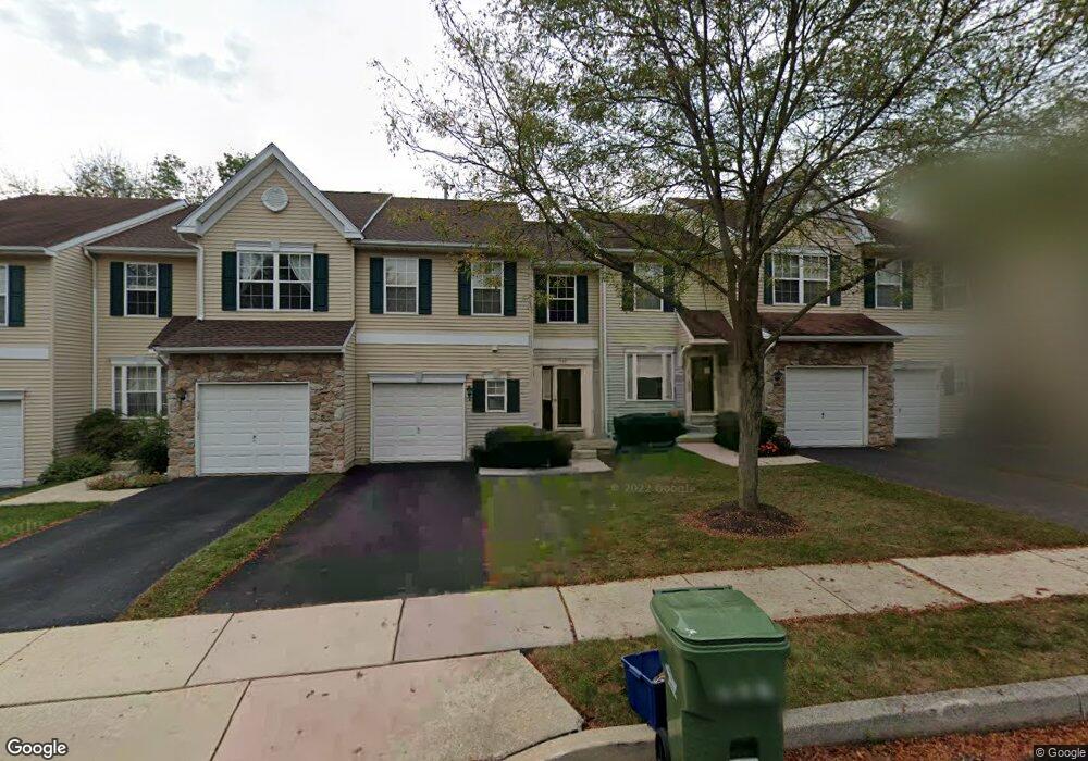
967 Katie Cir Royersford, PA 19468
Estimated Value: $393,000 - $418,000
3
Beds
3
Baths
1,520
Sq Ft
$265/Sq Ft
Est. Value
About This Home
This home is located at 967 Katie Cir, Royersford, PA 19468 and is currently estimated at $403,502, approximately $265 per square foot. 967 Katie Cir is a home located in Montgomery County with nearby schools including Royersford Elementary School, Spring-Ford Middle School 5/6/7 Grade Center, and Spring-Ford Middle School 8th Grade Center.
Ownership History
Date
Name
Owned For
Owner Type
Purchase Details
Closed on
Dec 8, 2004
Sold by
Not Provided
Bought by
Sowers Robert J
Current Estimated Value
Home Financials for this Owner
Home Financials are based on the most recent Mortgage that was taken out on this home.
Original Mortgage
$0
Interest Rate
5.63%
Purchase Details
Closed on
Dec 1, 2004
Sold by
Not Provided
Bought by
Sowers Robert J
Home Financials for this Owner
Home Financials are based on the most recent Mortgage that was taken out on this home.
Original Mortgage
$0
Interest Rate
5.63%
Purchase Details
Closed on
Jul 28, 1998
Sold by
Sukonik Indian Creek Corp
Bought by
Martin Brian
Create a Home Valuation Report for This Property
The Home Valuation Report is an in-depth analysis detailing your home's value as well as a comparison with similar homes in the area
Home Values in the Area
Average Home Value in this Area
Purchase History
| Date | Buyer | Sale Price | Title Company |
|---|---|---|---|
| Sowers Robert J | -- | -- | |
| Sowers Robert J | -- | -- | |
| Martin Brian | $142,430 | -- |
Source: Public Records
Mortgage History
| Date | Status | Borrower | Loan Amount |
|---|---|---|---|
| Closed | Sowers Robert J | $0 | |
| Closed | Sowers Robert J | $0 |
Source: Public Records
Tax History Compared to Growth
Tax History
| Year | Tax Paid | Tax Assessment Tax Assessment Total Assessment is a certain percentage of the fair market value that is determined by local assessors to be the total taxable value of land and additions on the property. | Land | Improvement |
|---|---|---|---|---|
| 2025 | $4,285 | $111,160 | $14,490 | $96,670 |
| 2024 | $4,285 | $111,160 | $14,490 | $96,670 |
| 2023 | $4,090 | $111,160 | $14,490 | $96,670 |
| 2022 | $3,952 | $111,160 | $14,490 | $96,670 |
| 2021 | $3,714 | $111,160 | $14,490 | $96,670 |
| 2020 | $3,616 | $111,160 | $14,490 | $96,670 |
| 2019 | $3,547 | $111,160 | $14,490 | $96,670 |
| 2018 | $2,784 | $111,160 | $14,490 | $96,670 |
| 2017 | $3,479 | $111,160 | $14,490 | $96,670 |
| 2016 | $3,435 | $111,160 | $14,490 | $96,670 |
| 2015 | $3,212 | $111,160 | $14,490 | $96,670 |
| 2014 | $3,212 | $111,160 | $14,490 | $96,670 |
Source: Public Records
Map
Nearby Homes
- 184 Providence Forge Rd
- 96 Providence Forge Rd
- 149 Roboda Blvd
- 36 Roboda Blvd
- 51 Roboda Blvd
- Granton Plan at Lewis Pointe
- 104 Beacon Ct Unit 10403
- 103 Beacon Ct Unit 10102
- 107 Beacon Ct Unit 10104
- 123 Beacon Ct Unit 10205
- 19 Iroquois Dr
- 604 Green St
- 804 Maple Ave
- 484 Fruit Farm Rd
- 209 Old State Rd
- 335 Arch St
- 518 Walnut St
- 414 2nd Ave
- 0 Main St Unit PAMC2088436
- 235 2nd Ave Unit 2