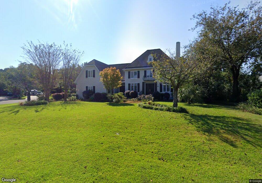
967 White Point Blvd Charleston, SC 29412
James Island NeighborhoodEstimated Value: $1,669,000 - $1,885,766
5
Beds
4
Baths
4,390
Sq Ft
$411/Sq Ft
Est. Value
About This Home
This home is located at 967 White Point Blvd, Charleston, SC 29412 and is currently estimated at $1,803,442, approximately $410 per square foot. 967 White Point Blvd is a home located in Charleston County with nearby schools including Harbor View Elementary School, Camp Road Middle, and James Island Charter High School.
Ownership History
Date
Name
Owned For
Owner Type
Purchase Details
Closed on
May 7, 2014
Sold by
Sora Iulian
Bought by
Sora Iulian and Sora Nicoleta
Current Estimated Value
Purchase Details
Closed on
Aug 30, 2013
Sold by
Gossett Robert A and Gossett Charlesana L
Bought by
Sora Iulian
Home Financials for this Owner
Home Financials are based on the most recent Mortgage that was taken out on this home.
Original Mortgage
$580,000
Outstanding Balance
$402,854
Interest Rate
2.74%
Mortgage Type
Adjustable Rate Mortgage/ARM
Estimated Equity
$1,400,588
Create a Home Valuation Report for This Property
The Home Valuation Report is an in-depth analysis detailing your home's value as well as a comparison with similar homes in the area
Home Values in the Area
Average Home Value in this Area
Purchase History
| Date | Buyer | Sale Price | Title Company |
|---|---|---|---|
| Sora Iulian | -- | -- | |
| Sora Iulian | $725,000 | -- |
Source: Public Records
Mortgage History
| Date | Status | Borrower | Loan Amount |
|---|---|---|---|
| Open | Sora Iulian | $580,000 |
Source: Public Records
Tax History Compared to Growth
Tax History
| Year | Tax Paid | Tax Assessment Tax Assessment Total Assessment is a certain percentage of the fair market value that is determined by local assessors to be the total taxable value of land and additions on the property. | Land | Improvement |
|---|---|---|---|---|
| 2024 | $4,265 | $33,350 | $0 | $0 |
| 2023 | $4,265 | $33,350 | $0 | $0 |
| 2022 | $4,006 | $33,350 | $0 | $0 |
| 2021 | $4,206 | $33,350 | $0 | $0 |
| 2020 | $4,364 | $33,350 | $0 | $0 |
| 2019 | $3,873 | $29,000 | $0 | $0 |
| 2017 | $3,736 | $29,000 | $0 | $0 |
| 2016 | $3,576 | $29,000 | $0 | $0 |
| 2015 | $3,699 | $29,000 | $0 | $0 |
| 2014 | $3,612 | $0 | $0 | $0 |
| 2011 | -- | $0 | $0 | $0 |
Source: Public Records
Map
Nearby Homes
- 924 White Point Blvd
- 881 Kushiwah Creek Dr
- 1026 Fort Sumter Dr
- 897 Kushiwah Creek Ct
- 825 Shutes Folly Dr
- 793 Shell Sand Rd
- 713 Lake Frances Dr
- 525 Yellow Tower Terrace
- 777 Lake Frances Dr
- 975 Harbor View Rd
- 969 Harbor View Rd
- 1077 Harbor View Rd
- 1110 Darwin St
- 620 N Shore Dr
- 816 Porcari St
- 3009 Allison Cove Dr
- 804 Porcari St
- 643 N Shore Dr
- 679 Edmonds Dr
- 683 Edmonds Dr
- 971 White Point Blvd
- 965 White Point Blvd
- 950 Carmel Dr
- 954 Carmel Dr
- 963 White Point Blvd
- 946 Carmel Dr
- 975 White Point Blvd
- 958 Carmel Dr
- 948 White Point Blvd
- 942 Carmel Dr
- 944 White Point Blvd
- 962 Carmel Dr
- 961 White Point Blvd
- 979 White Point Blvd
- 952 White Point Blvd
- 957 Paul Revere Dr
- 968 Kushiwah Creek Dr
- 955 Carmel Dr
- 951 Carmel Dr
- 665 Castle Pinckney Dr