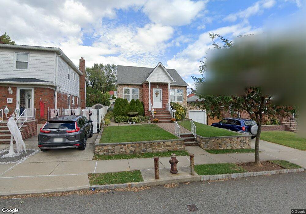
97 Cedarview Ave Staten Island, NY 10306
Oakwood NeighborhoodEstimated Value: $641,230 - $761,000
3
Beds
1
Bath
1,456
Sq Ft
$488/Sq Ft
Est. Value
About This Home
This home is located at 97 Cedarview Ave, Staten Island, NY 10306 and is currently estimated at $709,808, approximately $487 per square foot. 97 Cedarview Ave is a home located in Richmond County with nearby schools including P.S. 50 Frank Hankinson School, Myra S. Barnes Intermediate School 24, and New Dorp High School.
Ownership History
Date
Name
Owned For
Owner Type
Purchase Details
Closed on
Feb 7, 2022
Sold by
Immacolata Lombardo
Bought by
Immacolata Lombardo Irrevocable Trust
Current Estimated Value
Purchase Details
Closed on
Dec 1, 2005
Sold by
Mcalpin Donald and Mcalpin Christine
Bought by
Lombardo Nick and Lombardo Immacolata
Purchase Details
Closed on
Aug 12, 1996
Sold by
Schultz Alfred
Bought by
Mcalpin Donald and Mcalpin Christine
Create a Home Valuation Report for This Property
The Home Valuation Report is an in-depth analysis detailing your home's value as well as a comparison with similar homes in the area
Home Values in the Area
Average Home Value in this Area
Purchase History
| Date | Buyer | Sale Price | Title Company |
|---|---|---|---|
| Immacolata Lombardo Irrevocable Trust | -- | None Listed On Document | |
| Lombardo Nick | $455,000 | None Available | |
| Mcalpin Donald | $160,000 | First American Title Ins Co |
Source: Public Records
Tax History Compared to Growth
Tax History
| Year | Tax Paid | Tax Assessment Tax Assessment Total Assessment is a certain percentage of the fair market value that is determined by local assessors to be the total taxable value of land and additions on the property. | Land | Improvement |
|---|---|---|---|---|
| 2025 | $1,866 | $34,320 | $7,810 | $26,510 |
| 2024 | $1,970 | $29,700 | $8,515 | $21,185 |
| 2023 | $1,999 | $26,179 | $7,292 | $18,887 |
| 2022 | $1,802 | $32,520 | $9,660 | $22,860 |
| 2021 | $1,868 | $29,580 | $9,660 | $19,920 |
| 2020 | $1,788 | $28,440 | $9,660 | $18,780 |
| 2019 | $1,623 | $29,580 | $9,660 | $19,920 |
| 2018 | $1,565 | $21,816 | $7,586 | $14,230 |
| 2017 | $1,561 | $21,651 | $7,746 | $13,905 |
| 2016 | $1,421 | $20,426 | $8,912 | $11,514 |
| 2015 | $1,136 | $19,270 | $7,094 | $12,176 |
| 2014 | $1,136 | $18,180 | $8,040 | $10,140 |
Source: Public Records
Map
Nearby Homes
- 52 Farrell Ct
- 86 Cedarview Ave
- 30 Wolverine St
- 2889 Amboy Rd
- 39 Thomas St
- 56 Wolverine St
- 44 Thomas St
- 23 Acorn St
- 122 Guyon Ave
- 77 Acorn St
- 1915 N Railroad Ave
- 99 Acorn St
- 00 Savoy St Unit 12
- 16 Savoy St Unit 16
- 14 Savoy St Unit 14
- 100 Savoy St Unit 1, 39, 43, 45, 46
- 4 Penn Ave
- 351 8th St
- 194 Tysens Ln
- 32 Mobile Ave
- 103 Cedarview Ave
- 95 Cedarview Ave
- 105 Cedarview Ave
- 2970 Amboy Rd
- 89 Cedarview Ave
- 107 Cedarview Ave
- 30 Farrell Ct
- 32 Farrell Ct
- 28 Farrell Ct
- 34 Farrell Ct
- 26 Farrell Ct
- 24 Farrell Ct
- 36 Farrell Ct
- 81 Cedarview Ave
- 22 Farrell Ct
- 38 Farrell Ct
- 20 Farrell Ct
- 96 Cedarview Ave
- 40 Farrell Ct
- 90 Cedarview Ave Unit 1