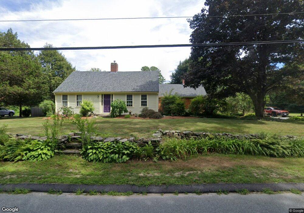
97 Chestnut St Rehoboth, MA 02769
Estimated Value: $554,834 - $679,000
4
Beds
2
Baths
1,697
Sq Ft
$365/Sq Ft
Est. Value
About This Home
This home is located at 97 Chestnut St, Rehoboth, MA 02769 and is currently estimated at $619,278, approximately $364 per square foot. 97 Chestnut St is a home located in Bristol County with nearby schools including Dighton-Rehoboth Regional High School and Cedar Brook School.
Ownership History
Date
Name
Owned For
Owner Type
Purchase Details
Closed on
Apr 6, 2021
Sold by
Hunnibell-Hitz Kylee L
Bought by
Hitz Ciril T
Current Estimated Value
Home Financials for this Owner
Home Financials are based on the most recent Mortgage that was taken out on this home.
Original Mortgage
$320,250
Outstanding Balance
$288,130
Interest Rate
3.05%
Mortgage Type
New Conventional
Estimated Equity
$331,148
Purchase Details
Closed on
May 12, 1999
Sold by
Hunnibell Kenneth L and Hunnibell Sherrill D
Bought by
Hitz Ciril and Hunnibell-Hitz Kylee
Home Financials for this Owner
Home Financials are based on the most recent Mortgage that was taken out on this home.
Original Mortgage
$89,000
Interest Rate
6.92%
Mortgage Type
Purchase Money Mortgage
Create a Home Valuation Report for This Property
The Home Valuation Report is an in-depth analysis detailing your home's value as well as a comparison with similar homes in the area
Home Values in the Area
Average Home Value in this Area
Purchase History
| Date | Buyer | Sale Price | Title Company |
|---|---|---|---|
| Hitz Ciril T | -- | None Available | |
| Hitz Ciril | $179,000 | -- |
Source: Public Records
Mortgage History
| Date | Status | Borrower | Loan Amount |
|---|---|---|---|
| Open | Hitz Ciril T | $320,250 | |
| Previous Owner | Hitz Ciril | $178,000 | |
| Previous Owner | Hitz Ciril | $98,000 | |
| Previous Owner | Hitz Ciril | $89,000 |
Source: Public Records
Tax History
| Year | Tax Paid | Tax Assessment Tax Assessment Total Assessment is a certain percentage of the fair market value that is determined by local assessors to be the total taxable value of land and additions on the property. | Land | Improvement |
|---|---|---|---|---|
| 2025 | $52 | $462,600 | $193,000 | $269,600 |
| 2024 | $4,936 | $434,500 | $193,000 | $241,500 |
| 2023 | $4,944 | $426,900 | $189,000 | $237,900 |
| 2022 | $4,659 | $367,700 | $180,600 | $187,100 |
| 2021 | $2,964 | $351,400 | $164,300 | $187,100 |
| 2020 | $4,540 | $346,000 | $164,300 | $181,700 |
| 2018 | $3,744 | $312,800 | $156,500 | $156,300 |
| 2017 | $2,470 | $294,600 | $156,500 | $138,100 |
| 2016 | $3,514 | $289,200 | $156,500 | $132,700 |
| 2015 | $3,758 | $305,300 | $149,300 | $156,000 |
| 2014 | $3,593 | $288,800 | $142,100 | $146,700 |
Source: Public Records
Map
Nearby Homes
- 8 Linden Ln
- 8 Linden Ln
- 185 Moulton St
- 20 School St
- 111 Summer St
- 197 Chestnut St
- 42 Linden Ln
- 248 County
- 46 Mikayla Ann Dr
- 0 Winter St
- 321 Winthrop St
- 145 Winthrop St
- 139 Winthrop St
- 23 Bay State Rd
- 0 Winthrop St Unit 73180872
- 67 Wheeler St
- 48 Broad St
- 23 Colonial Way
- 75 Martin St
- 19 Cedar St Unit 21
- 95 Chestnut St
- 103 Chestnut St
- 85 Chestnut St
- 2 Williamsfield Ln
- 6 Williamsfield Ln
- 1 Williamsfield Ln
- 108 Chestnut St
- 5 Williamsfield Ln
- 78 Chestnut St
- 79 Chestnut St
- 88 Chestnut St
- 117 Chestnut St
- 114 Chestnut St
- 74 Chestnut St
- 74R Chestnut St
- 118 Chestnut St
- 73 Chestnut St
- 8 Stoney Brook Rd
- 2 Damascus Rd
- 121 Chestnut St
Your Personal Tour Guide
Ask me questions while you tour the home.