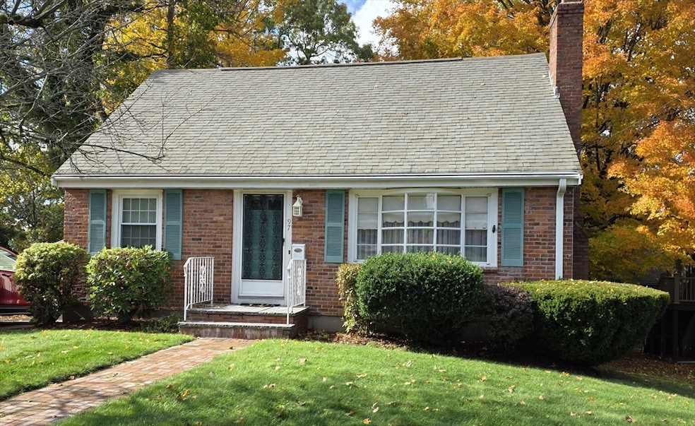
97 Liberty St Braintree, MA 02184
East Braintree NeighborhoodEstimated payment $4,093/month
Highlights
- 0.47 Acre Lot
- Deck
- Wooded Lot
- Cape Cod Architecture
- Property is near public transit
- 4-minute walk to Jonas Perkins Park
About This Home
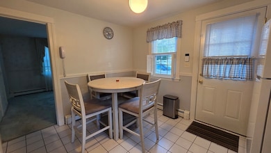
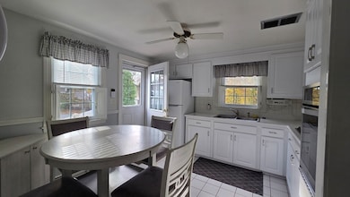
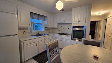
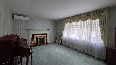
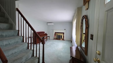
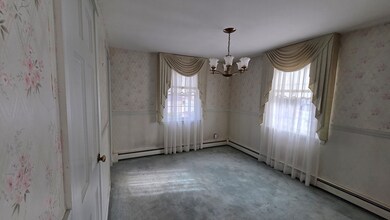
Welcome home to 97 Liberty St, a charming 3-bedroom, 1.5-bath Cape set on nearly half an acre in desirable Braintree! This 1,656 sq. ft. home blends classic character with thoughtful updates, featuring a warm living room with a wood-burning fireplace, hardwood floors, and plenty of natural light. The kitchen boasts Corian countertops, tile flooring, and exterior access to a composite deck overlooking a fenced, level yard—perfect for relaxing or entertaining. Upstairs, you'll find two spacious bedrooms, including a primary with a walk-in closet. Additional highlights include a partially finished walk-out basement with a family room, mini-split cooling, gas heat, a Shed, and off-street parking for three. Conveniently located near schools, shopping, parks, and major highways, with easy access to the MBTA and local amenities. Move-in ready and full of potential—don’t miss this Liberty Street gem!
Open House Schedule
-
Saturday, November 15, 202511:00 am to 1:00 pm11/15/2025 11:00:00 AM +00:0011/15/2025 1:00:00 PM +00:00First open house Saturday, 11 AM to 1 PM.Add to Calendar
Home Details
Home Type
- Single Family
Est. Annual Taxes
- $6,441
Year Built
- Built in 1952
Lot Details
- 0.47 Acre Lot
- Fenced
- Level Lot
- Wooded Lot
Home Design
- Cape Cod Architecture
- Frame Construction
- Shingle Roof
- Concrete Perimeter Foundation
Interior Spaces
- Light Fixtures
- Insulated Windows
- Window Screens
- Insulated Doors
- Living Room with Fireplace
- Dining Area
- Washer and Electric Dryer Hookup
Kitchen
- Oven
- Range with Range Hood
- Solid Surface Countertops
Flooring
- Wood
- Wall to Wall Carpet
- Concrete
- Ceramic Tile
- Vinyl
Bedrooms and Bathrooms
- 3 Bedrooms
- Primary bedroom located on second floor
- Dual Closets
- Walk-In Closet
- Separate Shower
- Linen Closet In Bathroom
Partially Finished Basement
- Walk-Out Basement
- Basement Fills Entire Space Under The House
- Interior Basement Entry
- Block Basement Construction
- Laundry in Basement
Home Security
- Home Security System
- Storm Doors
Parking
- 3 Car Parking Spaces
- Tandem Parking
- Driveway
- Paved Parking
- Open Parking
- Off-Street Parking
Eco-Friendly Details
- Energy-Efficient Thermostat
Outdoor Features
- Deck
- Outdoor Storage
- Rain Gutters
- Porch
Location
- Property is near public transit
- Property is near schools
Utilities
- Ductless Heating Or Cooling System
- 3 Cooling Zones
- Heating System Uses Natural Gas
- Baseboard Heating
- 220 Volts
- 110 Volts
- 100 Amp Service
- Gas Water Heater
- High Speed Internet
Listing and Financial Details
- Assessor Parcel Number M:3026 B:0 L:10,22051
Community Details
Overview
- No Home Owners Association
- Near Conservation Area
Amenities
- Shops
Recreation
- Tennis Courts
- Park
- Jogging Path
Map
Home Values in the Area
Average Home Value in this Area
Tax History
| Year | Tax Paid | Tax Assessment Tax Assessment Total Assessment is a certain percentage of the fair market value that is determined by local assessors to be the total taxable value of land and additions on the property. | Land | Improvement |
|---|---|---|---|---|
| 2025 | $6,441 | $645,400 | $383,200 | $262,200 |
| 2024 | $5,862 | $618,400 | $360,000 | $258,400 |
| 2023 | $5,553 | $569,000 | $325,100 | $243,900 |
| 2022 | $5,431 | $545,800 | $301,900 | $243,900 |
| 2021 | $4,985 | $501,000 | $278,700 | $222,300 |
| 2020 | $4,711 | $477,800 | $255,500 | $222,300 |
| 2019 | $4,639 | $459,800 | $255,500 | $204,300 |
| 2018 | $4,512 | $428,100 | $232,200 | $195,900 |
| 2017 | $4,255 | $396,200 | $209,000 | $187,200 |
| 2016 | $4,032 | $367,200 | $185,800 | $181,400 |
| 2015 | $3,869 | $349,500 | $175,300 | $174,200 |
| 2014 | $3,733 | $326,900 | $167,200 | $159,700 |
Property History
| Date | Event | Price | List to Sale | Price per Sq Ft |
|---|---|---|---|---|
| 11/12/2025 11/12/25 | For Sale | $675,900 | -- | $408 / Sq Ft |
Purchase History
| Date | Type | Sale Price | Title Company |
|---|---|---|---|
| Deed | -- | -- | |
| Deed | $765,000 | -- |
Source: MLS Property Information Network (MLS PIN)
MLS Number: 73454175
APN: BRAI-003026-000000-000010
Disclaimer: Certain information contained herein is derived from information provided by parties other than Homes.com. All information provided is deemed reliable, but is not guaranteed to be accurate and should be independently verified.
![]() The property listing data and information, or the Images, set forth herein were provided to MLS Property Information Network, Inc. from third party sources, including sellers, lessors and public records, and were compiled by MLS Property Information Network, Inc. The property listing data and information, and the Images, are for the personal, non-commercial use of consumers having a good faith interest in purchasing or leasing listed properties of the type displayed to them and may not be used for any purpose other than to identify prospective properties which such consumers may have a good faith interest in purchasing or leasing. MLS Property Information Network, Inc. and its subscribers disclaim any and all representations and warranties as to the accuracy of the property listing data and information, or as to the accuracy of any of the Images, set forth herein.
The property listing data and information, or the Images, set forth herein were provided to MLS Property Information Network, Inc. from third party sources, including sellers, lessors and public records, and were compiled by MLS Property Information Network, Inc. The property listing data and information, and the Images, are for the personal, non-commercial use of consumers having a good faith interest in purchasing or leasing listed properties of the type displayed to them and may not be used for any purpose other than to identify prospective properties which such consumers may have a good faith interest in purchasing or leasing. MLS Property Information Network, Inc. and its subscribers disclaim any and all representations and warranties as to the accuracy of the property listing data and information, or as to the accuracy of any of the Images, set forth herein.
- 685 Union St
- 51 Faxon St
- 21 Faxon St
- 71 Robbie Rd
- 230 Lisle St
- 145 Commercial St Unit 3
- 141 Commercial St Unit 9
- 36 Brookside Rd
- 31 Tingley Rd
- 15 Summer St
- 83 Edgemont Rd
- 122 Washington St Unit 22
- 141 Hobart St
- 69 Dobson Rd
- 11 Richmond St
- 67 Somerville Ave
- 312 Shaw St
- 16 Lindbergh Ave
- 23-25 Lindbergh Ave
- 605 Middle St Unit 38
- 139 Stetson St Unit 2
- 305 Commercial St Unit 305
- 139-2 Stetson St Unit 2
- 287 Commercial St Unit 11
- 323 Commercial St Unit 3
- 22 Hamilton St
- 32 Sheppard Ave Unit 32
- 30 Sheppard Ave Unit 30
- 391 Commercial St
- 79 Shaw
- 2 Mccusker Dr
- 25 Commercial St
- 10 Front St Unit 303
- 22 Washington St
- 143 Washington St
- 21 Common St Unit 1
- 167 Middle St Unit 2
- 483 Liberty St Unit 2
- 125 Broad St
- 34 Drinkwater Ave Unit 2
