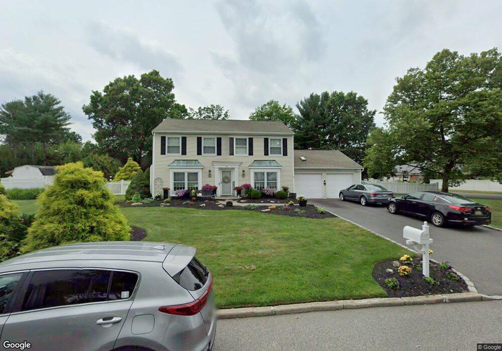
97 Manchester Ln Stony Brook, NY 11790
Estimated Value: $761,965 - $965,000
4
Beds
2
Baths
2,186
Sq Ft
$392/Sq Ft
Est. Value
About This Home
This home is located at 97 Manchester Ln, Stony Brook, NY 11790 and is currently estimated at $857,741, approximately $392 per square foot. 97 Manchester Ln is a home located in Suffolk County with nearby schools including William Sidney Mount School, Robert Cushman Murphy Junior High School, and Ward Melville Senior High School.
Ownership History
Date
Name
Owned For
Owner Type
Purchase Details
Closed on
Jun 27, 2000
Sold by
Spector Laura M
Bought by
Roberts Thomas W and Roberts Eileen M
Current Estimated Value
Home Financials for this Owner
Home Financials are based on the most recent Mortgage that was taken out on this home.
Original Mortgage
$235,000
Outstanding Balance
$85,995
Interest Rate
8.55%
Estimated Equity
$771,746
Purchase Details
Closed on
Jul 15, 1997
Sold by
Gesualdo Richard and Gesualdo Carolyn
Bought by
Spector Laura M
Create a Home Valuation Report for This Property
The Home Valuation Report is an in-depth analysis detailing your home's value as well as a comparison with similar homes in the area
Home Values in the Area
Average Home Value in this Area
Purchase History
| Date | Buyer | Sale Price | Title Company |
|---|---|---|---|
| Roberts Thomas W | $310,000 | Fidelity National Title Ins | |
| Spector Laura M | $205,000 | First American Title Ins Co |
Source: Public Records
Mortgage History
| Date | Status | Borrower | Loan Amount |
|---|---|---|---|
| Open | Roberts Thomas W | $235,000 |
Source: Public Records
Tax History Compared to Growth
Tax History
| Year | Tax Paid | Tax Assessment Tax Assessment Total Assessment is a certain percentage of the fair market value that is determined by local assessors to be the total taxable value of land and additions on the property. | Land | Improvement |
|---|---|---|---|---|
| 2024 | $16,242 | $3,600 | $425 | $3,175 |
| 2023 | $16,242 | $3,600 | $425 | $3,175 |
| 2022 | $13,116 | $3,500 | $425 | $3,075 |
| 2021 | $13,116 | $3,500 | $425 | $3,075 |
| 2020 | $14,727 | $3,500 | $425 | $3,075 |
| 2019 | $14,727 | $0 | $0 | $0 |
| 2018 | $12,787 | $3,500 | $425 | $3,075 |
| 2017 | $12,787 | $3,500 | $425 | $3,075 |
| 2016 | $12,569 | $3,500 | $425 | $3,075 |
| 2015 | -- | $3,500 | $425 | $3,075 |
| 2014 | -- | $3,500 | $425 | $3,075 |
Source: Public Records
Map
Nearby Homes
- 419 Elton Ct E
- 501 Drew Dr
- 107 Fairfield Dr N
- 37 Malvern Ln
- 4 Mystic Ct
- 914 Fenway Rd
- 908 Fenway Rd
- 43 Millbrook Dr
- 6 Freshman Ln
- 704 Cabot Ct W Unit C704
- 607 Cabot Ct E Unit C607
- 106 Cabot Ct W
- 51 Glenridge Ave
- 102 Gotham Way
- 1 University Heights Dr
- 404 Oxhead Rd
- 204 Bentley Ct E Unit B204
- 1306 Gotham Ct W
- 3 Bowen Place
- 7 Pensdale Ct
- 99 Manchester Ln
- 21 Westwood Ave
- 95 Manchester Ln
- 19 Westwood Ave
- 82 Manchester Ln
- 80 Manchester Ln
- 8 Lynbrook Rd
- 84 Manchester Ln
- 101 Manchester Ln
- 78 Manchester Ln
- 6 Lynbrook Rd
- 17 Westwood Ave
- 86 Manchester Ln
- 16 Westwood Ave
- 24 Madeley Ln
- 9 Singingwood Dr
- 14 Westwood Ave
- 22 Madeley Ln
- 7 Singingwood Dr
- 76 Manchester Ln