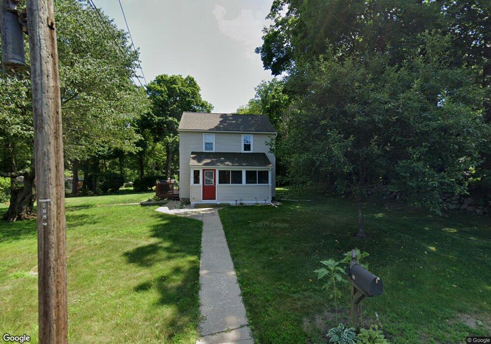
97 Maple Ave Higganum, CT 06441
Estimated Value: $318,000 - $486,000
3
Beds
1
Bath
1,152
Sq Ft
$319/Sq Ft
Est. Value
About This Home
This home is located at 97 Maple Ave, Higganum, CT 06441 and is currently estimated at $367,299, approximately $318 per square foot. 97 Maple Ave is a home located in Middlesex County with nearby schools including Haddam-Killingworth High School.
Ownership History
Date
Name
Owned For
Owner Type
Purchase Details
Closed on
Jun 14, 1999
Sold by
Rustek Michael and Rustek Jeanne M
Bought by
Kauffman Keith C and Kauffman Lisa M
Current Estimated Value
Purchase Details
Closed on
Mar 4, 1996
Sold by
Johnson Ellen Est
Bought by
Rustek Michael and Rustek Jeanne M
Purchase Details
Closed on
Dec 19, 1994
Sold by
Patterson John
Bought by
Hoyt Edward N and Hoyt Deborah R
Create a Home Valuation Report for This Property
The Home Valuation Report is an in-depth analysis detailing your home's value as well as a comparison with similar homes in the area
Home Values in the Area
Average Home Value in this Area
Purchase History
| Date | Buyer | Sale Price | Title Company |
|---|---|---|---|
| Kauffman Keith C | $152,000 | -- | |
| Kauffman Keith C | $152,000 | -- | |
| Rustek Michael | $120,000 | -- | |
| Rustek Michael | $120,000 | -- | |
| Hoyt Edward N | $230,000 | -- | |
| Hoyt Edward N | $230,000 | -- |
Source: Public Records
Mortgage History
| Date | Status | Borrower | Loan Amount |
|---|---|---|---|
| Open | Hoyt Edward N | $25,000 | |
| Closed | Hoyt Edward N | $128,000 |
Source: Public Records
Tax History
| Year | Tax Paid | Tax Assessment Tax Assessment Total Assessment is a certain percentage of the fair market value that is determined by local assessors to be the total taxable value of land and additions on the property. | Land | Improvement |
|---|---|---|---|---|
| 2025 | $4,529 | $131,860 | $64,030 | $67,830 |
| 2024 | $4,565 | $132,890 | $65,060 | $67,830 |
| 2023 | $4,501 | $132,890 | $65,060 | $67,830 |
| 2022 | $4,296 | $132,890 | $65,060 | $67,830 |
| 2021 | $4,274 | $132,890 | $65,060 | $67,830 |
| 2020 | $4,479 | $145,700 | $76,010 | $69,690 |
| 2019 | $4,617 | $145,700 | $76,010 | $69,690 |
| 2018 | $4,429 | $145,700 | $76,010 | $69,690 |
| 2017 | $4,268 | $145,700 | $76,010 | $69,690 |
| 2016 | $4,546 | $145,700 | $76,010 | $69,690 |
| 2015 | $4,693 | $150,420 | $76,010 | $74,410 |
| 2014 | $4,646 | $150,420 | $76,010 | $74,410 |
Source: Public Records
Map
Nearby Homes
- 214 Thayer Rd
- 86 Christian Hill Rd
- 30 High St
- 26 Boulder Dell Rd
- 16 Walkley Hill Rd
- 0 S Dish Mill Rd Unit 24082788
- 210 Dripps Rd
- 0 Mountain Laurel Dr
- 3 Copley Rd
- 44 Chamberlain Hill Rd
- 0 Saybrook Rd
- 215 Chamberlain Hill Rd
- 291 Injun Hollow Rd
- 195A Injun Hollow Rd
- 523 Chamberlain Hill Rd
- 37 Arkona Dr
- 63 Burr Rd
- 678 Bartholomew Rd
- 2 Stone Bridge Dr Unit Lot 2
- 59 Hidden Lake Rd
Your Personal Tour Guide
Ask me questions while you tour the home.