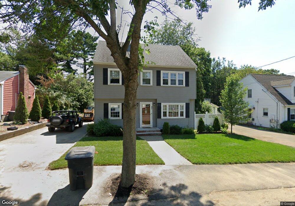
97 Wesson Ave Quincy, MA 02169
Estimated Value: $652,000 - $723,436
3
Beds
1
Bath
1,511
Sq Ft
$459/Sq Ft
Est. Value
About This Home
This home is located at 97 Wesson Ave, Quincy, MA 02169 and is currently estimated at $693,609, approximately $459 per square foot. 97 Wesson Ave is a home located in Norfolk County with nearby schools including South West Middle School, Lincoln-Hancock Community School, and Quincy High School.
Ownership History
Date
Name
Owned For
Owner Type
Purchase Details
Closed on
Oct 28, 2020
Sold by
Connolly Bryan T and Connolly Julie A
Bought by
Connolly Julie A
Current Estimated Value
Purchase Details
Closed on
Aug 24, 1998
Sold by
Mcgill Camilla A
Bought by
Connolly Bryan T and Connolly Julie A
Home Financials for this Owner
Home Financials are based on the most recent Mortgage that was taken out on this home.
Original Mortgage
$146,750
Interest Rate
6.86%
Mortgage Type
Purchase Money Mortgage
Purchase Details
Closed on
Jan 24, 1997
Sold by
Bourgeois Isabel Est
Bought by
Mcgill Camilla A
Home Financials for this Owner
Home Financials are based on the most recent Mortgage that was taken out on this home.
Original Mortgage
$68,000
Interest Rate
7.5%
Mortgage Type
Purchase Money Mortgage
Create a Home Valuation Report for This Property
The Home Valuation Report is an in-depth analysis detailing your home's value as well as a comparison with similar homes in the area
Purchase History
| Date | Buyer | Sale Price | Title Company |
|---|---|---|---|
| Connolly Julie A | -- | None Available | |
| Connolly Bryan T | $154,500 | -- | |
| Mcgill Camilla A | $85,000 | -- |
Source: Public Records
Mortgage History
| Date | Status | Borrower | Loan Amount |
|---|---|---|---|
| Previous Owner | Mcgill Camilla A | $155,000 | |
| Previous Owner | Mcgill Camilla A | $146,750 | |
| Previous Owner | Mcgill Camilla A | $68,000 |
Source: Public Records
Tax History
| Year | Tax Paid | Tax Assessment Tax Assessment Total Assessment is a certain percentage of the fair market value that is determined by local assessors to be the total taxable value of land and additions on the property. | Land | Improvement |
|---|---|---|---|---|
| 2025 | $7,891 | $684,400 | $314,700 | $369,700 |
| 2024 | $7,466 | $662,500 | $299,900 | $362,600 |
| 2023 | $6,947 | $624,200 | $285,800 | $338,400 |
| 2022 | $6,529 | $545,000 | $229,100 | $315,900 |
| 2021 | $6,415 | $528,400 | $229,100 | $299,300 |
| 2020 | $6,232 | $501,400 | $229,100 | $272,300 |
| 2019 | $6,257 | $498,600 | $222,600 | $276,000 |
| 2018 | $6,146 | $460,700 | $206,300 | $254,400 |
| 2017 | $6,066 | $428,100 | $196,600 | $231,500 |
| 2016 | $5,691 | $396,300 | $179,000 | $217,300 |
| 2015 | $5,498 | $376,600 | $169,000 | $207,600 |
| 2014 | $5,320 | $358,000 | $169,000 | $189,000 |
Source: Public Records
Map
Nearby Homes
- 36 Village Dr
- 87 Village Dr
- 51 Branch St Unit 2
- 9 Westford St
- 510 Willard St
- 25 McDonald St
- 459 Willard St Unit 303
- 21 Totman St Unit 308
- 21 Totman St Unit 205
- 21 Totman St Unit 404
- 21 Totman St Unit 309
- 21 Totman St Unit 203
- 21 Totman St Unit PH-406
- 21 Totman St Unit 301
- 21 Totman St Unit PH-405
- 21 Totman St Unit 407
- 132 Centre St
- 57 Buckley St
- 211 Copeland St
- 21 Arthur St
Your Personal Tour Guide
Ask me questions while you tour the home.