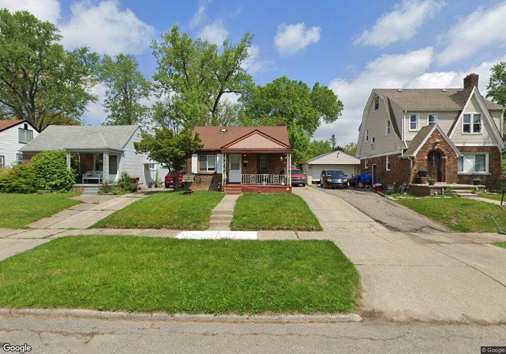
970 Berwick Blvd Pontiac, MI 48341
Estimated Value: $116,000 - $158,446
3
Beds
1
Bath
968
Sq Ft
$151/Sq Ft
Est. Value
About This Home
This home is located at 970 Berwick Blvd, Pontiac, MI 48341 and is currently estimated at $146,612, approximately $151 per square foot. 970 Berwick Blvd is a home located in Oakland County with nearby schools including Walt Whitman Elementary School, Pontiac Middle School, and Pontiac High School.
Ownership History
Date
Name
Owned For
Owner Type
Purchase Details
Closed on
Dec 16, 2016
Sold by
Gwh Properties Llc
Bought by
Pottier And Co Llc
Current Estimated Value
Purchase Details
Closed on
Apr 10, 2015
Sold by
Harvey Cory Lashone
Bought by
Gwh Properties Llc
Purchase Details
Closed on
Mar 27, 2015
Sold by
Terry Stanley
Bought by
Harvey Cory
Purchase Details
Closed on
Jan 16, 2015
Sold by
Tassin Dinah Marie
Bought by
Harvey Cory Leshone
Purchase Details
Closed on
Oct 1, 1996
Sold by
Terry Beverly A
Bought by
Terry Stanley
Create a Home Valuation Report for This Property
The Home Valuation Report is an in-depth analysis detailing your home's value as well as a comparison with similar homes in the area
Home Values in the Area
Average Home Value in this Area
Purchase History
| Date | Buyer | Sale Price | Title Company |
|---|---|---|---|
| Pottier And Co Llc | $62,000 | Fidelity National Title | |
| Gwh Properties Llc | $35,000 | None Available | |
| Harvey Cory | -- | None Available | |
| Harvey Cory Leshone | $1,000 | None Available | |
| Terry Stanley | $100 | -- |
Source: Public Records
Tax History
| Year | Tax Paid | Tax Assessment Tax Assessment Total Assessment is a certain percentage of the fair market value that is determined by local assessors to be the total taxable value of land and additions on the property. | Land | Improvement |
|---|---|---|---|---|
| 2025 | $1,639 | $59,930 | $0 | $0 |
| 2024 | $1,514 | $54,970 | $0 | $0 |
| 2023 | $1,443 | $48,340 | $0 | $0 |
| 2022 | $2,255 | $42,350 | $0 | $0 |
| 2021 | $1,411 | $35,860 | $0 | $0 |
| 2020 | $1,311 | $32,700 | $0 | $0 |
| 2019 | $1,370 | $29,110 | $0 | $0 |
| 2018 | $1,325 | $24,780 | $0 | $0 |
| 2017 | $1,470 | $22,430 | $0 | $0 |
| 2016 | $1,263 | $19,580 | $0 | $0 |
| 2015 | -- | $17,890 | $0 | $0 |
| 2014 | -- | $17,470 | $0 | $0 |
| 2011 | -- | $24,730 | $0 | $0 |
Source: Public Records
Map
Nearby Homes
- 1061 Dorchester Ave
- 000 Lake St
- 1755 Wellington Ave
- 0000 Ward Road Ward Rd
- 40 Canal Dr Unit 300-040
- 1785 Ward Rd
- 258 Voorheis St
- 285 Voorheis St
- 18 Edna Ave
- 1179 Oaklawn Dr
- 2051 Avondale St
- 10 Wenonah Dr
- 38 Hazel Ave
- 2085 Pontiac Dr
- 2021 Klingensmith Rd Unit 88
- 2021 Klingensmith Rd Unit 83
- 1223 Oaklawn Dr
- 215 Oak Ridge Dr
- 142 Ottawa Dr
- 403 Voorheis St
- 964 Berwick Blvd
- 974 Berwick Blvd
- 504 Avon Rd
- 978 Berwick Blvd
- 956 Berwick Blvd
- 982 Berwick Blvd
- 512 Avon Rd
- 979 Canterbury Dr
- 975 Canterbury Dr
- 986 Berwick Blvd
- 983 Canterbury Dr
- 967 Berwick Blvd
- 971 Berwick Blvd
- 959 Berwick Blvd
- 963 Berwick Blvd
- 990 Berwick Blvd
- 975 Berwick Blvd
- 987 Canterbury Dr
- 979 Berwick Blvd
- 989 Canterbury Dr
Your Personal Tour Guide
Ask me questions while you tour the home.