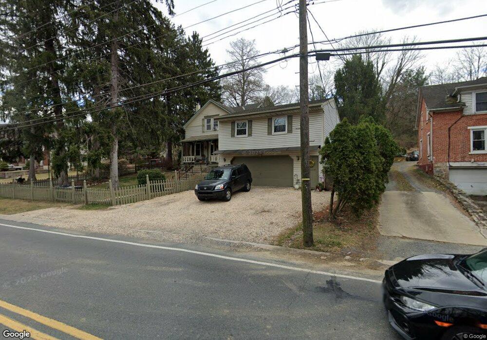
970 Butter Ln Reading, PA 19606
Estimated Value: $298,747 - $339,000
4
Beds
2
Baths
2,236
Sq Ft
$139/Sq Ft
Est. Value
About This Home
This home is located at 970 Butter Ln, Reading, PA 19606 and is currently estimated at $311,437, approximately $139 per square foot. 970 Butter Ln is a home located in Berks County with nearby schools including Jacksonwald Elementary School, Exeter Township Junior High School, and Exeter Township Senior High School.
Ownership History
Date
Name
Owned For
Owner Type
Purchase Details
Closed on
Jul 20, 2007
Sold by
Sands Donna A and Scibek Donna A
Bought by
Jones Michael and Jones Lisa
Current Estimated Value
Home Financials for this Owner
Home Financials are based on the most recent Mortgage that was taken out on this home.
Original Mortgage
$199,800
Outstanding Balance
$145,386
Interest Rate
9.95%
Mortgage Type
Adjustable Rate Mortgage/ARM
Estimated Equity
$166,051
Create a Home Valuation Report for This Property
The Home Valuation Report is an in-depth analysis detailing your home's value as well as a comparison with similar homes in the area
Home Values in the Area
Average Home Value in this Area
Purchase History
| Date | Buyer | Sale Price | Title Company |
|---|---|---|---|
| Jones Michael | $222,000 | None Available |
Source: Public Records
Mortgage History
| Date | Status | Borrower | Loan Amount |
|---|---|---|---|
| Open | Jones Michael | $199,800 |
Source: Public Records
Tax History Compared to Growth
Tax History
| Year | Tax Paid | Tax Assessment Tax Assessment Total Assessment is a certain percentage of the fair market value that is determined by local assessors to be the total taxable value of land and additions on the property. | Land | Improvement |
|---|---|---|---|---|
| 2025 | $1,586 | $100,800 | $27,200 | $73,600 |
| 2024 | $4,787 | $100,800 | $27,200 | $73,600 |
| 2023 | $4,630 | $100,800 | $27,200 | $73,600 |
| 2022 | $4,579 | $100,800 | $27,200 | $73,600 |
| 2021 | $4,509 | $100,800 | $27,200 | $73,600 |
| 2020 | $4,459 | $100,800 | $27,200 | $73,600 |
| 2019 | $4,410 | $100,800 | $27,200 | $73,600 |
| 2018 | $4,397 | $100,800 | $27,200 | $73,600 |
| 2017 | $4,333 | $100,800 | $27,200 | $73,600 |
| 2016 | $1,097 | $100,800 | $27,200 | $73,600 |
| 2015 | $1,097 | $100,800 | $27,200 | $73,600 |
| 2014 | $1,059 | $100,800 | $27,200 | $73,600 |
Source: Public Records
Map
Nearby Homes
- 1034 Butter Ln
- 1125 Deer Run
- 1020 Sterling Ave
- 1261 Fox Run
- 1280 Fox Run
- 222 Opal Ave
- 923 Carsonia Ave
- 115 Mayer St
- 2509 Park St
- 174 Taft Ave
- 1305 Carsonia Ave
- 41 Aldine Ave
- 606 Brighton Ave
- 1425 Friedensburg Rd
- 1440 Friedensburg Rd
- 507 N 26th St
- 505 Brighton Ave
- 3024 Oley Turnpike Rd
- 505 Friedensburg Rd
- 430 Carsonia Ave