Estimated Value: $146,000 - $216,742
Studio
--
Bath
2,698
Sq Ft
$67/Sq Ft
Est. Value
About This Home
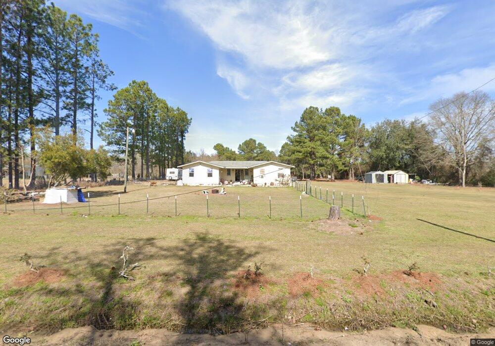
This home is located at 970 McConnell Bridge Rd, Adel, GA 31620 and is currently estimated at $181,371, approximately $67 per square foot. 970 McConnell Bridge Rd is a home located in Cook County with nearby schools including Cook Primary School, Cook Elementary School, and Cook County Middle School.
Ownership History
Date
Name
Owned For
Owner Type
Purchase Details
Closed on
Sep 14, 2018
Sold by
Cook County Land Ventures Llc
Bought by
Freeman Benjamin G
Current Estimated Value
Home Financials for this Owner
Home Financials are based on the most recent Mortgage that was taken out on this home.
Original Mortgage
$81,496
Outstanding Balance
$71,720
Interest Rate
5.5%
Mortgage Type
FHA
Estimated Equity
$109,651
Purchase Details
Closed on
May 18, 2010
Sold by
Farmers & Merchants Bank
Bought by
Cook County Land Ventures Llc
Purchase Details
Closed on
Dec 1, 2009
Sold by
Bennett Tommy Allen
Bought by
Farmers & Merchants Bank
Purchase Details
Closed on
Sep 28, 2006
Sold by
Nocent Yves
Bought by
Bennett Tommy Allen
Create a Home Valuation Report for This Property
The Home Valuation Report is an in-depth analysis detailing your home's value as well as a comparison with similar homes in the area
Home Values in the Area
Average Home Value in this Area
Purchase History
| Date | Buyer | Sale Price | Title Company |
|---|---|---|---|
| Freeman Benjamin G | $83,000 | -- | |
| Cook County Land Ventures Llc | $20,000 | -- | |
| Farmers & Merchants Bank | $40,000 | -- | |
| Bennett Tommy Allen | $55,500 | -- |
Source: Public Records
Mortgage History
| Date | Status | Borrower | Loan Amount |
|---|---|---|---|
| Open | Freeman Benjamin G | $81,496 |
Source: Public Records
Tax History
| Year | Tax Paid | Tax Assessment Tax Assessment Total Assessment is a certain percentage of the fair market value that is determined by local assessors to be the total taxable value of land and additions on the property. | Land | Improvement |
|---|---|---|---|---|
| 2025 | $554 | $27,404 | $9,564 | $17,840 |
| 2024 | $600 | $24,273 | $7,560 | $16,713 |
| 2023 | $531 | $21,727 | $7,560 | $14,167 |
| 2022 | $510 | $20,917 | $6,750 | $14,167 |
| 2021 | $466 | $18,058 | $6,750 | $11,308 |
| 2020 | $466 | $18,058 | $6,750 | $11,308 |
| 2019 | $522 | $18,058 | $6,750 | $11,308 |
| 2018 | $522 | $18,058 | $6,750 | $11,308 |
| 2017 | $522 | $18,058 | $6,750 | $11,308 |
| 2016 | $523 | $18,058 | $6,750 | $11,308 |
| 2015 | $524 | $18,058 | $6,750 | $11,308 |
| 2014 | $525 | $18,058 | $6,750 | $11,308 |
| 2013 | -- | $18,058 | $6,750 | $11,308 |
Source: Public Records
Map
Nearby Homes
- 515 John Keigans Memorial
- 91 Apple Ln
- 123 Westover Dr
- 414 Birch St
- 134 Brandy Ct
- 801 Glendale St
- 703 N Elm St
- 11 Antioch Rd
- 729 W Seventh St
- 5429 Georgia 76
- 507 S Poplar St
- 814 N Cleveland Ave
- 309 Wayne St
- 411 S Hutchinson Ave
- 211 S Gordon Ave
- 1607 Jimmy St
- 111 Brookside Dr
- 313 S Forrest Ave
- 526 E Mitchell St
- 509 E 8th St
- 1009 Park Bridge
- 1100 McConnell Bridge Rd
- 858 McConnell Bridge Rd
- 1268 McConnell Bridge Rd
- 354 McConnell Bridge Rd
- 921 County Farm Rd
- 268 McConnell Bridge Rd
- 638 County Farm Rd
- 643 John Keigans
- 714 County Farm Rd
- 1465 McConnell Bridge Rd
- 1476 McConnell Bridge Rd
- 1486 McConnell Bridge Rd
- 0 McConnell Bridge Rd
- 3792 McConnell Bridge Rd
- 3796 McConnell Bridge Rd
- 318 Airport Square
- 643 John Keigens Memorial Rd
- 1542 McConnell Bridge Rd
- 52 McConnell Bridge Rd
Your Personal Tour Guide
Ask me questions while you tour the home.