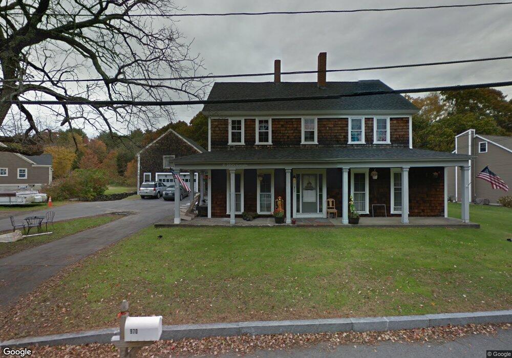
970 N Main St Raynham, MA 02767
Estimated Value: $784,351 - $793,000
6
Beds
2
Baths
3,833
Sq Ft
$206/Sq Ft
Est. Value
About This Home
This home is located at 970 N Main St, Raynham, MA 02767 and is currently estimated at $789,838, approximately $206 per square foot. 970 N Main St is a home located in Bristol County with nearby schools including Merrill Elementary School, LaLiberte Elementary School, and Williams Intermediate School.
Ownership History
Date
Name
Owned For
Owner Type
Purchase Details
Closed on
Jan 30, 2026
Sold by
Wells Karl D
Bought by
Rubini Joseph
Current Estimated Value
Home Financials for this Owner
Home Financials are based on the most recent Mortgage that was taken out on this home.
Original Mortgage
$707,162
Outstanding Balance
$707,162
Interest Rate
6.21%
Mortgage Type
FHA
Estimated Equity
$82,676
Purchase Details
Closed on
Jul 13, 2015
Sold by
Lillian M Hewitt T and Bank Of America Na Tr
Bought by
Wells Karl D
Purchase Details
Closed on
Dec 23, 2011
Sold by
Scaduto John and Scaduto Marey L
Bought by
970 North Main Street and Scaduto
Purchase Details
Closed on
Nov 18, 2011
Sold by
Bank Of Amrica Na
Bought by
Almeida Manuel S
Purchase Details
Closed on
Nov 16, 2011
Sold by
Bank Of America Na
Bought by
Almeida Manuel S
Purchase Details
Closed on
Jun 4, 2009
Sold by
Lillian M Hewitt T and Bank Of America Na
Bought by
Scaduto John and Scaduto Marcy L
Create a Home Valuation Report for This Property
The Home Valuation Report is an in-depth analysis detailing your home's value as well as a comparison with similar homes in the area
Home Values in the Area
Average Home Value in this Area
Purchase History
| Date | Buyer | Sale Price | Title Company |
|---|---|---|---|
| Rubini Joseph | $795,000 | -- | |
| Wells Karl D | $220,000 | -- | |
| 970 North Main Street | -- | -- | |
| Almeida Manuel S | $88,500 | -- | |
| Almeida Manuel S | $88,500 | -- | |
| Almeida Manuel S | $88,500 | -- | |
| Almeida Manuel S | $88,500 | -- | |
| Scaduto John | $105,000 | -- |
Source: Public Records
Mortgage History
| Date | Status | Borrower | Loan Amount |
|---|---|---|---|
| Open | Rubini Joseph | $707,162 |
Source: Public Records
Tax History
| Year | Tax Paid | Tax Assessment Tax Assessment Total Assessment is a certain percentage of the fair market value that is determined by local assessors to be the total taxable value of land and additions on the property. | Land | Improvement |
|---|---|---|---|---|
| 2025 | $9,768 | $807,300 | $221,400 | $585,900 |
| 2024 | $8,893 | $716,000 | $201,400 | $514,600 |
| 2023 | $7,759 | $570,500 | $181,200 | $389,300 |
| 2022 | $8,056 | $543,200 | $171,200 | $372,000 |
| 2021 | $0 | $533,200 | $161,200 | $372,000 |
| 2020 | $7,568 | $525,200 | $153,200 | $372,000 |
| 2019 | $7,048 | $495,300 | $143,200 | $352,100 |
| 2018 | $4,450 | $475,900 | $135,200 | $340,700 |
| 2017 | $5,379 | $357,900 | $129,200 | $228,700 |
| 2016 | $4,710 | $314,400 | $125,200 | $189,200 |
| 2015 | $4,625 | $303,500 | $116,500 | $187,000 |
Source: Public Records
Map
Nearby Homes
- 84 Diniz Dr
- 33 White St
- 2 Maplewood Ln Unit 21-1
- 0 Maplewood Unit 21.3 73426136
- 26 Nottingham Dr
- 123 Center St
- 16 Fieldstone Dr
- 21 Sully Rd
- 4-B High Ridge Dr
- 30 Edward Rd
- 75 Sunflower Dr
- 658 Broadway
- 314 Britton St
- 646 Broadway
- 634 Broadway
- 000 Old Pleasant St
- 54 Ann St
- 138 Carver St
- 53 Queens Cir
- 1540 Broadway Unit 35
Your Personal Tour Guide
Ask me questions while you tour the home.