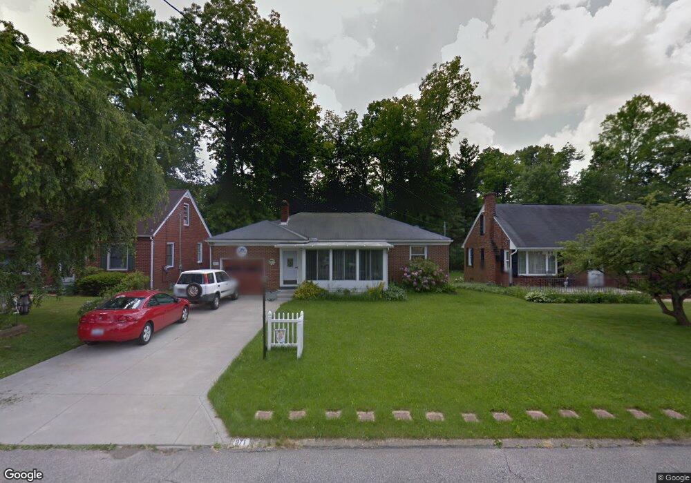
971 Paxford Place Mansfield, OH 44906
Estimated Value: $131,000 - $154,000
2
Beds
1
Bath
1,154
Sq Ft
$123/Sq Ft
Est. Value
About This Home
This home is located at 971 Paxford Place, Mansfield, OH 44906 and is currently estimated at $141,656, approximately $122 per square foot. 971 Paxford Place is a home located in Richland County with nearby schools including Mansfield Elective Academy, Interactive Media & Construction (IMAC) Academy, and Cypress High School.
Ownership History
Date
Name
Owned For
Owner Type
Purchase Details
Closed on
Nov 19, 2002
Sold by
Wirick Anna J
Bought by
Guzzo Garry L and Guzzo Lorie L
Current Estimated Value
Home Financials for this Owner
Home Financials are based on the most recent Mortgage that was taken out on this home.
Original Mortgage
$81,151
Outstanding Balance
$34,191
Interest Rate
6.1%
Mortgage Type
FHA
Estimated Equity
$107,465
Purchase Details
Closed on
Aug 22, 1995
Sold by
Fair Herbert E
Bought by
Wirick Howard and Wirick Anna J
Create a Home Valuation Report for This Property
The Home Valuation Report is an in-depth analysis detailing your home's value as well as a comparison with similar homes in the area
Home Values in the Area
Average Home Value in this Area
Purchase History
| Date | Buyer | Sale Price | Title Company |
|---|---|---|---|
| Guzzo Garry L | $82,425 | -- | |
| Wirick Howard | $70,000 | -- |
Source: Public Records
Mortgage History
| Date | Status | Borrower | Loan Amount |
|---|---|---|---|
| Open | Guzzo Garry L | $81,151 |
Source: Public Records
Tax History Compared to Growth
Tax History
| Year | Tax Paid | Tax Assessment Tax Assessment Total Assessment is a certain percentage of the fair market value that is determined by local assessors to be the total taxable value of land and additions on the property. | Land | Improvement |
|---|---|---|---|---|
| 2024 | $1,769 | $37,780 | $6,060 | $31,720 |
| 2023 | $1,769 | $37,780 | $6,060 | $31,720 |
| 2022 | $1,656 | $29,630 | $5,200 | $24,430 |
| 2021 | $1,667 | $29,630 | $5,200 | $24,430 |
| 2020 | $1,705 | $29,630 | $5,200 | $24,430 |
| 2019 | $1,889 | $29,630 | $5,200 | $24,430 |
| 2018 | $1,863 | $29,630 | $5,200 | $24,430 |
| 2017 | $1,813 | $29,630 | $5,200 | $24,430 |
| 2016 | $1,806 | $28,620 | $5,490 | $23,130 |
| 2015 | $1,725 | $28,620 | $5,490 | $23,130 |
| 2014 | $1,703 | $28,620 | $5,490 | $23,130 |
| 2012 | $683 | $30,130 | $5,780 | $24,350 |
Source: Public Records
Map
Nearby Homes
- 232 S Trimble Rd Unit 234
- 244 S Trimble Rd Unit 246
- 216 S Trimble Rd Unit 218
- 1068 Linwood Place
- 190 S Linden Rd
- 143 Kingwood Place
- 142 Grasmere Ave
- 212 Marlow Rd
- 191 Fairlawn Ave
- 37 S Linden Rd
- 143 Fairlawn Ave
- 135 Fairlawn Ave
- 129 Fairlawn Ave
- 408 Fairlawn Ave
- 679 Coleman Rd
- 0 Old Mill Run Rd Unit 9067543
- 0 Old Mill Run Rd Unit 9067542
- 1157 Deer Run Rd
- 118 Parkwood Blvd
- 0 Deer Run Rd
- 977 Paxford Place
- 965 Paxford Place
- 959 Paxford Place
- 225 S Trimble Rd
- 968 Linwood Place
- 953 Paxford Place
- 966 Linwood Place
- 972 Paxford Place
- 954 Linwood Place
- 978 Paxford Place
- 966 Paxford Place
- 976 Linwood Place
- 962 Paxford Place
- 949 Paxford Place
- 986 Paxford Place
- 950 Linwood Place
- 958 Paxford Place
- 946 Linwood Place
- 956 Paxford Place
- 941 Paxford Place Unit 943