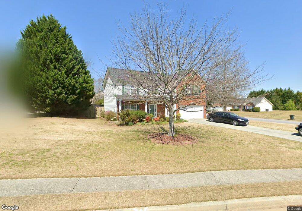
971 Rolling Meadows Dr Loganville, GA 30052
Estimated Value: $354,000 - $371,561
4
Beds
3
Baths
2,312
Sq Ft
$158/Sq Ft
Est. Value
About This Home
This home is located at 971 Rolling Meadows Dr, Loganville, GA 30052 and is currently estimated at $366,140, approximately $158 per square foot. 971 Rolling Meadows Dr is a home located in Gwinnett County with nearby schools including Magill Elementary School, Grace Snell Middle School, and South Gwinnett High School.
Ownership History
Date
Name
Owned For
Owner Type
Purchase Details
Closed on
Dec 14, 2001
Sold by
Taylor Knox Homes Inc
Bought by
Kumodzi Victoria
Current Estimated Value
Home Financials for this Owner
Home Financials are based on the most recent Mortgage that was taken out on this home.
Original Mortgage
$151,539
Outstanding Balance
$65,036
Interest Rate
6.49%
Mortgage Type
New Conventional
Estimated Equity
$301,104
Create a Home Valuation Report for This Property
The Home Valuation Report is an in-depth analysis detailing your home's value as well as a comparison with similar homes in the area
Home Values in the Area
Average Home Value in this Area
Purchase History
| Date | Buyer | Sale Price | Title Company |
|---|---|---|---|
| Kumodzi Victoria | $154,000 | -- |
Source: Public Records
Mortgage History
| Date | Status | Borrower | Loan Amount |
|---|---|---|---|
| Open | Kumodzi Victoria | $151,539 |
Source: Public Records
Tax History Compared to Growth
Tax History
| Year | Tax Paid | Tax Assessment Tax Assessment Total Assessment is a certain percentage of the fair market value that is determined by local assessors to be the total taxable value of land and additions on the property. | Land | Improvement |
|---|---|---|---|---|
| 2024 | $3,848 | $136,720 | $30,000 | $106,720 |
| 2023 | $3,848 | $143,680 | $29,680 | $114,000 |
| 2022 | $3,399 | $117,080 | $22,000 | $95,080 |
| 2021 | $2,882 | $90,360 | $16,000 | $74,360 |
| 2020 | $2,644 | $78,440 | $14,000 | $64,440 |
| 2019 | $2,571 | $78,440 | $14,000 | $64,440 |
| 2018 | $2,502 | $75,240 | $12,000 | $63,240 |
| 2016 | $2,388 | $68,960 | $9,600 | $59,360 |
| 2015 | $1,966 | $51,440 | $9,600 | $41,840 |
| 2014 | $1,975 | $51,440 | $9,600 | $41,840 |
Source: Public Records
Map
Nearby Homes
- 1107 Kingston Hill Dr
- 1107 Kingston Hill Dr Unit 52-B
- 3765 Brushy Wood Dr
- 996 Lakeview Oaks Ct Unit 25-B
- 996 Lakeview Oaks Ct
- 3315 Linstead Ct
- 3315 Linstead Ct Unit 2A
- 1010 Burning Bush Dr Unit 2
- 1210 Burning Bush Dr
- 411 Ryland Ave
- The Auburn Plan at Soleil at Summit Chase
- The Jefferson Plan at Soleil at Summit Chase
- The Montrose Plan at Soleil at Summit Chase
- The Edison Plan at Soleil at Summit Chase
- The Pearson Plan at Soleil at Summit Chase
- The Tifton Plan at Soleil at Summit Chase
- The Weston Plan at Soleil at Summit Chase
- The Wesley Plan at Soleil at Summit Chase
- The Denton Plan at Soleil at Summit Chase
- 3819 Tielman St
- 981 Rolling Meadows Dr
- 3670 Brushy Wood Dr
- 3665 Brushy Wood Dr
- 961 Rolling Meadows Dr
- 991 Rolling Meadows Dr
- 978 Rolling Meadows Dr
- 988 Rolling Meadows Dr
- 3660 Brushy Wood Dr
- 3655 Brushy Wood Dr Unit 6
- 3655 Brushy Wood Dr
- 998 Rolling Meadows Dr
- 951 Rolling Meadows Dr
- 3683 Rolling Meadows Way Unit 17
- 3683 Rolling Meadows Way
- 968 Rolling Meadows Dr
- 1001 Rolling Meadows Dr
- 959 Stepp Ct Unit 1
- 3650 Brushy Wood Dr
- 3673 Rolling Meadows Way
- 3645 Brushy Wood Dr Unit 2