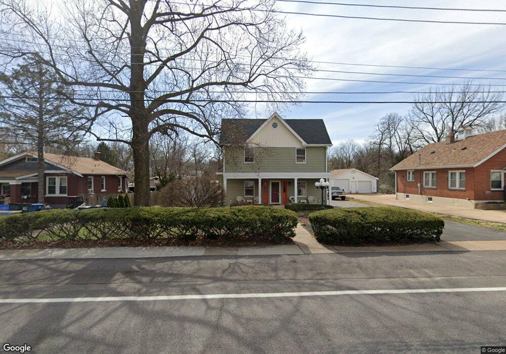
9710 Midland Blvd Saint Louis, MO 63114
Estimated Value: $175,000 - $255,000
3
Beds
3
Baths
1,816
Sq Ft
$126/Sq Ft
Est. Value
About This Home
This home is located at 9710 Midland Blvd, Saint Louis, MO 63114 and is currently estimated at $228,252, approximately $125 per square foot. 9710 Midland Blvd is a home located in St. Louis County with nearby schools including Marion Elementary School, Ritenour Middle School, and Ritenour Senior High School.
Ownership History
Date
Name
Owned For
Owner Type
Purchase Details
Closed on
Sep 13, 2005
Sold by
Dillon Candice A
Bought by
Dillon Marvin K
Current Estimated Value
Purchase Details
Closed on
Sep 30, 1999
Sold by
Emmendorfer Michael C and Emmendorfer Janet M
Bought by
Dillon Marvin K and Dillon Candace
Home Financials for this Owner
Home Financials are based on the most recent Mortgage that was taken out on this home.
Original Mortgage
$130,836
Outstanding Balance
$38,818
Interest Rate
7.83%
Mortgage Type
FHA
Estimated Equity
$189,434
Create a Home Valuation Report for This Property
The Home Valuation Report is an in-depth analysis detailing your home's value as well as a comparison with similar homes in the area
Home Values in the Area
Average Home Value in this Area
Purchase History
| Date | Buyer | Sale Price | Title Company |
|---|---|---|---|
| Dillon Marvin K | -- | -- | |
| Dillon Marvin K | $131,000 | -- |
Source: Public Records
Mortgage History
| Date | Status | Borrower | Loan Amount |
|---|---|---|---|
| Open | Dillon Marvin K | $130,836 |
Source: Public Records
Tax History Compared to Growth
Tax History
| Year | Tax Paid | Tax Assessment Tax Assessment Total Assessment is a certain percentage of the fair market value that is determined by local assessors to be the total taxable value of land and additions on the property. | Land | Improvement |
|---|---|---|---|---|
| 2025 | $3,104 | $40,200 | $11,550 | $28,650 |
| 2024 | $3,104 | $36,370 | $2,950 | $33,420 |
| 2023 | $3,104 | $36,370 | $2,950 | $33,420 |
| 2022 | $2,729 | $28,660 | $2,530 | $26,130 |
| 2021 | $2,728 | $28,660 | $2,530 | $26,130 |
| 2020 | $2,660 | $25,780 | $3,630 | $22,150 |
| 2019 | $2,632 | $25,780 | $3,630 | $22,150 |
| 2018 | $2,356 | $20,750 | $2,980 | $17,770 |
| 2017 | $2,246 | $20,750 | $2,980 | $17,770 |
| 2016 | $1,776 | $16,670 | $2,340 | $14,330 |
| 2015 | $1,817 | $16,670 | $2,340 | $14,330 |
| 2014 | -- | $17,400 | $3,990 | $13,410 |
Source: Public Records
Map
Nearby Homes
- 9640 Tennyson Ave
- 2528 Leslie Ave
- 2529 Leslie Ave
- 2412 Wallis Ave
- 9911 Dennison Ave
- 9515 Marlowe Ave
- 9922 Carlyle Ave
- 3205 Airway Ave
- 3213 Airway Ave
- 9432 Tudor Ave
- 3219 Royalton Ave
- 3219 Coles Ave
- 3222 W Tennyson Ave
- 2812 Woodson Rd
- 2326 Hood Ave
- 3301 Suncrest Ave
- 2327 Gaebler Ave
- 10027 Breckenridge Rd
- 3329 W Milton Ave
- 3316 Edmundson Rd
- 9714 Midland Blvd
- 9706 Midland Blvd
- 9702 Midland Blvd
- 9716 Midland Blvd
- 9718 Midland Blvd
- 2613 W Milton Ave
- 9722 Midland Blvd
- 2609 W Milton Ave
- 9648 Midland Blvd
- 2624 W Milton Ave
- 9724 Midland Blvd
- 2622 W Milton Ave
- 9644 Midland Blvd Unit None
- 9644 Midland Blvd
- 2605 W Milton Ave
- 9705 Midland Blvd
- 9701 Midland Blvd
- 9726 Midland Blvd
- 9631 Holtwood Rd
- 9721 Midland Blvd