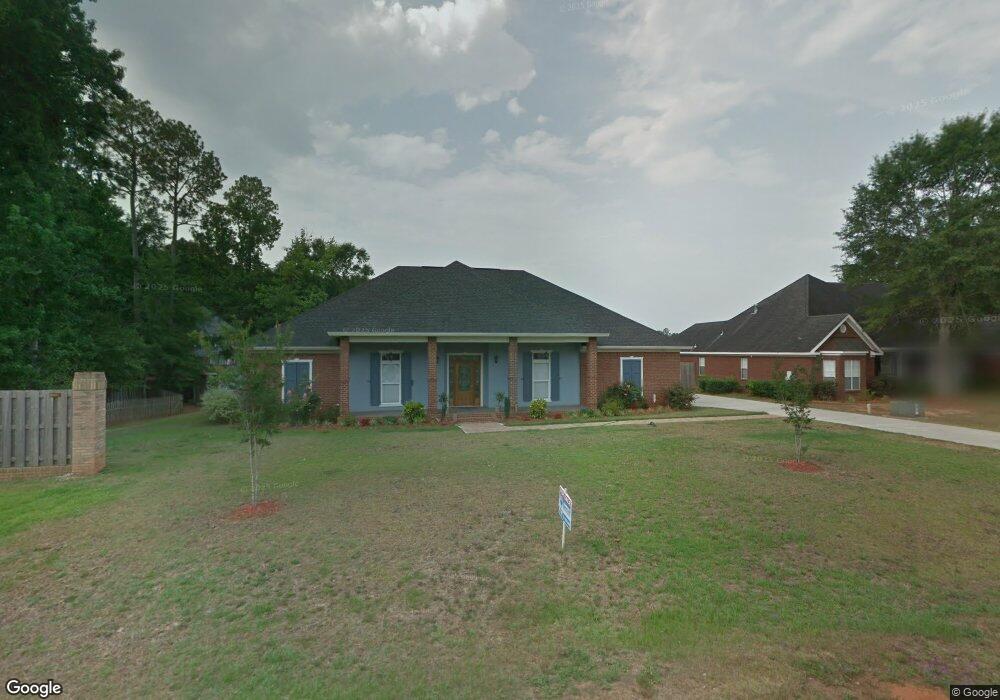
9715 Scott Dairy Loop Rd S Mobile, AL 36695
Dawes NeighborhoodEstimated Value: $372,508 - $570,000
4
Beds
3
Baths
2,777
Sq Ft
$160/Sq Ft
Est. Value
About This Home
This home is located at 9715 Scott Dairy Loop Rd S, Mobile, AL 36695 and is currently estimated at $444,127, approximately $159 per square foot. 9715 Scott Dairy Loop Rd S is a home located in Mobile County with nearby schools including Hutchens Elementary School, Dawes Intermediate School, and Bernice J Causey Middle School.
Ownership History
Date
Name
Owned For
Owner Type
Purchase Details
Closed on
Feb 20, 2015
Sold by
Martin Michael and Martin Pamela B
Bought by
Metzger Carl T and Merzger Jo Anne
Current Estimated Value
Home Financials for this Owner
Home Financials are based on the most recent Mortgage that was taken out on this home.
Original Mortgage
$267,563
Outstanding Balance
$202,978
Interest Rate
3.74%
Mortgage Type
FHA
Estimated Equity
$241,149
Purchase Details
Closed on
Dec 8, 2006
Sold by
Cooper Jordan R
Bought by
Martin Michael and Martin Pamela B
Create a Home Valuation Report for This Property
The Home Valuation Report is an in-depth analysis detailing your home's value as well as a comparison with similar homes in the area
Home Values in the Area
Average Home Value in this Area
Purchase History
| Date | Buyer | Sale Price | Title Company |
|---|---|---|---|
| Metzger Carl T | $272,500 | None Available | |
| Martin Michael | -- | None Available |
Source: Public Records
Mortgage History
| Date | Status | Borrower | Loan Amount |
|---|---|---|---|
| Open | Metzger Carl T | $267,563 |
Source: Public Records
Tax History
| Year | Tax Paid | Tax Assessment Tax Assessment Total Assessment is a certain percentage of the fair market value that is determined by local assessors to be the total taxable value of land and additions on the property. | Land | Improvement |
|---|---|---|---|---|
| 2025 | $1,693 | $33,800 | $5,500 | $28,300 |
| 2024 | $1,693 | $32,330 | $5,500 | $26,830 |
| 2023 | $1,621 | $32,070 | $5,250 | $26,820 |
| 2022 | $1,318 | $28,530 | $5,250 | $23,280 |
| 2021 | $1,331 | $28,800 | $5,250 | $23,550 |
| 2020 | $1,344 | $29,070 | $5,250 | $23,820 |
| 2019 | $1,375 | $29,740 | $0 | $0 |
| 2018 | $1,327 | $28,740 | $0 | $0 |
| 2017 | $1,316 | $28,520 | $0 | $0 |
| 2016 | $1,329 | $28,780 | $0 | $0 |
| 2013 | $1,460 | $31,180 | $0 | $0 |
Source: Public Records
Map
Nearby Homes
- 9700 Scott Dairy Loop Rd S
- 3560 Arlington Oaks Dr
- 3740 Latigo Rd
- 3411 Spring Meadow Dr E
- 9598 Estate Dr
- 3230 Bloomington Dr
- 3255 Scott Dairy Loop Rd W
- 3582 Magnolia Downs E
- 3790 Arlington Oaks Dr
- 9548 McRae Place Ct
- 3176 Essex Place Dr
- 10040 Country Rd
- 9534 Labrador Run N
- 9497 Labrador Run S
- 3105 Scott Place Ct
- 3580 McFarland Trace Ct
- 9681 Old Abilene Ct S
- 3376 Hartsfield Way E
- 3060 Scott Place Ct
- 9259 Mcfarland Way
- 3510 Arlington Oaks Dr
- 9700 Potomac Ridge Dr Unit 1
- 3520 Arlington Oaks Dr
- 9739 Scott Dairy Loop Rd S
- 9710 Potomac Ridge Dr
- 9710 Scott Dairy Loop Rd S
- 3481 Plantation Ct
- 9720 Potomac Ridge Dr
- 9749 Scott Dairy Loop Rd S
- 3540 Arlington Oaks Dr
- 9678 Scott Dairy Loop Rd S
- 3471 Plantation Ct
- 3521 Arlington Oaks Dr
- 9715 Potomac Ridge Dr
- 9730 Potomac Ridge Dr
- 9779 Scott Dairy Loop Rd S
- 9660 Scott Dairy Loop Rd S
- 3541 Arlington Oaks Dr
- 9725 Potomac Ridge Dr
- 9701 Spring Meadow Dr S
Your Personal Tour Guide
Ask me questions while you tour the home.