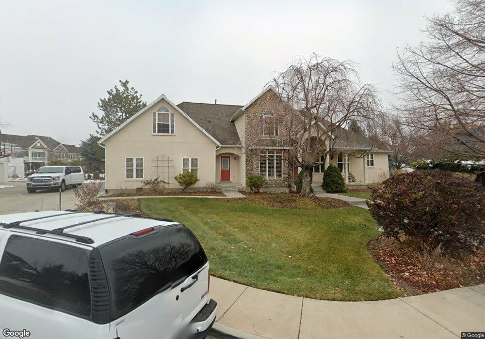
972 W 2200 N Pleasant Grove, UT 84062
Estimated Value: $1,036,000 - $1,294,796
6
Beds
5
Baths
5,382
Sq Ft
$219/Sq Ft
Est. Value
About This Home
This home is located at 972 W 2200 N, Pleasant Grove, UT 84062 and is currently estimated at $1,177,449, approximately $218 per square foot. 972 W 2200 N is a home located in Utah County with nearby schools including Manila Elementary School, Pleasant Grove Junior High School, and Pleasant Grove High School.
Ownership History
Date
Name
Owned For
Owner Type
Purchase Details
Closed on
May 8, 2020
Sold by
Jorgensen Steven F and Jorgensen Family Trust
Bought by
Jorgensen Josh Daniel and Jorgensen Discretionary Trust
Current Estimated Value
Purchase Details
Closed on
Aug 19, 2016
Sold by
Jorgensen Steven F and Jorgensen Michelle C
Bought by
Jorgensen Steven F
Purchase Details
Closed on
Oct 17, 2012
Sold by
Palmer David E and Palmer Sheri P
Bought by
Jorgensen Steven E and Jorgensen Michelle C
Home Financials for this Owner
Home Financials are based on the most recent Mortgage that was taken out on this home.
Original Mortgage
$380,000
Interest Rate
3.52%
Mortgage Type
New Conventional
Create a Home Valuation Report for This Property
The Home Valuation Report is an in-depth analysis detailing your home's value as well as a comparison with similar homes in the area
Home Values in the Area
Average Home Value in this Area
Purchase History
| Date | Buyer | Sale Price | Title Company |
|---|---|---|---|
| Jorgensen Josh Daniel | -- | None Available | |
| Jorgensen Steven F | -- | None Available | |
| Jorgensen Steven E | -- | None Available |
Source: Public Records
Mortgage History
| Date | Status | Borrower | Loan Amount |
|---|---|---|---|
| Previous Owner | Jorgensen Steven E | $380,000 |
Source: Public Records
Tax History Compared to Growth
Tax History
| Year | Tax Paid | Tax Assessment Tax Assessment Total Assessment is a certain percentage of the fair market value that is determined by local assessors to be the total taxable value of land and additions on the property. | Land | Improvement |
|---|---|---|---|---|
| 2025 | $5,022 | $676,830 | $527,800 | $702,800 |
| 2024 | $5,022 | $599,280 | $0 | $0 |
| 2023 | $4,864 | $594,275 | $0 | $0 |
| 2022 | $4,807 | $584,375 | $0 | $0 |
| 2021 | $4,041 | $748,000 | $300,300 | $447,700 |
| 2020 | $3,817 | $692,600 | $278,100 | $414,500 |
| 2019 | $3,585 | $672,800 | $258,300 | $414,500 |
| 2018 | $3,680 | $652,900 | $238,400 | $414,500 |
| 2017 | $3,715 | $350,900 | $0 | $0 |
| 2016 | $3,617 | $329,890 | $0 | $0 |
| 2015 | $3,752 | $324,005 | $0 | $0 |
| 2014 | $3,615 | $309,265 | $0 | $0 |
Source: Public Records
Map
Nearby Homes
- 1897 N 900 W
- 980 W 1800 N
- 532 W 2000 N
- 2254 N 1560 W
- 598 N 1280 E
- 636 N 1280 E
- 674 W 1590 N Unit 11
- 649 N 1280 E
- 2837 N 550 W
- 731 W 1590 N Unit 15
- Konlee Plan at Makin Dreams
- Alexa Plan at Makin Dreams
- Callahan Plan at Makin Dreams
- Hailey Plan at Makin Dreams
- Alydia Plan at Makin Dreams
- Addison Plan at Makin Dreams
- Julia Plan at Makin Dreams
- 1531 N 750 W Unit 4
- Aaron Plan at Makin Dreams
- Amie Plan at Makin Dreams
- 946 W 2200 N
- 1022 W 2200 N
- 2282 N 1050 W
- 987 W 2310 N
- 2282 Northfield Cir Unit 5
- 961 W 2310 N
- 987 Northfield Dr Unit 3
- 987 Northfield Dr
- 918 W 2200 N
- 2294 N 1050 W
- 955 W 2200 N
- 987 W 2200 N
- 2275 Northfield Cir Unit 6
- 961 Northfield Dr Unit 2
- 2294 Northfield Cir Unit 4
- 2275 N 1050 W
- 2277 N 900 W
- 933 W 2200 N
- 911 W 2200 N
- 2281 Northfield Cir Unit 7