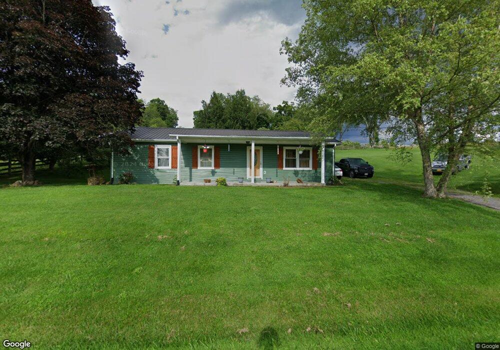
973 Tattle Branch Rd Chilhowie, VA 24319
Estimated Value: $147,907 - $228,000
3
Beds
2
Baths
1,280
Sq Ft
$144/Sq Ft
Est. Value
About This Home
This home is located at 973 Tattle Branch Rd, Chilhowie, VA 24319 and is currently estimated at $184,477, approximately $144 per square foot. 973 Tattle Branch Rd is a home located in Smyth County with nearby schools including Chilhowie Elementary School, Chilhowie Middle School, and Chilhowie High School.
Ownership History
Date
Name
Owned For
Owner Type
Purchase Details
Closed on
Jul 9, 2009
Sold by
Wayne Mark D
Bought by
Taylor Mckinsey L and Taylor Aimee N
Current Estimated Value
Home Financials for this Owner
Home Financials are based on the most recent Mortgage that was taken out on this home.
Original Mortgage
$82,800
Interest Rate
5.31%
Mortgage Type
New Conventional
Purchase Details
Closed on
Jan 8, 2008
Sold by
Hall Ralph G and Hall Phyllis T
Bought by
Wayne Mark D
Home Financials for this Owner
Home Financials are based on the most recent Mortgage that was taken out on this home.
Original Mortgage
$85,129
Interest Rate
7.25%
Mortgage Type
New Conventional
Create a Home Valuation Report for This Property
The Home Valuation Report is an in-depth analysis detailing your home's value as well as a comparison with similar homes in the area
Home Values in the Area
Average Home Value in this Area
Purchase History
| Date | Buyer | Sale Price | Title Company |
|---|---|---|---|
| Taylor Mckinsey L | $92,000 | -- | |
| Wayne Mark D | $89,610 | -- |
Source: Public Records
Mortgage History
| Date | Status | Borrower | Loan Amount |
|---|---|---|---|
| Closed | Taylor Mckinsey L | $82,800 | |
| Previous Owner | Wayne Mark D | $85,129 |
Source: Public Records
Tax History Compared to Growth
Tax History
| Year | Tax Paid | Tax Assessment Tax Assessment Total Assessment is a certain percentage of the fair market value that is determined by local assessors to be the total taxable value of land and additions on the property. | Land | Improvement |
|---|---|---|---|---|
| 2025 | $651 | $110,400 | $18,000 | $92,400 |
| 2024 | $651 | $110,400 | $18,000 | $92,400 |
| 2023 | $539 | $72,900 | $15,000 | $57,900 |
| 2022 | $539 | $72,900 | $15,000 | $57,900 |
| 2021 | $539 | $72,900 | $15,000 | $57,900 |
| 2020 | $539 | $72,900 | $15,000 | $57,900 |
| 2019 | $482 | $65,200 | $15,000 | $50,200 |
| 2018 | $482 | $65,200 | $15,000 | $50,200 |
| 2017 | $482 | $65,200 | $15,000 | $50,200 |
| 2016 | $482 | $65,200 | $15,000 | $50,200 |
| 2015 | $482 | $0 | $0 | $0 |
| 2014 | $457 | $0 | $0 | $0 |
Source: Public Records
Map
Nearby Homes
- 1219 Chestnut Ridge Rd
- 38 Brooke St
- 23 Christin Ln
- 21 Christin Ln
- 25 Christin Ln
- TBD Lot#19 Christin Ln
- TBD Lot#15 Chestnutwood Dr
- TBD Lot#42 Brooke St
- TBD Lot#8 Elem Dr
- TBD Lo #24 Christin Ln
- TBD Lot#12 Chestnutwood Dr
- TBD Lot#46 Chestnutwood Dr
- TBD Lot#37 Brooke St
- TBD Lot#13 Chestnutwood Dr
- TBD Lot#4 Elem Dr
- TBD Lot#3 Elem Dr
- TBD Lot#45 Chestnutwood Dr
- TBD Lot#17 Bryant Dr
- TBD Lot#10 Elem Dr
- TBD Lot#40 Brooke St
- 109 Whisper Creek Ln
- 1021 Tattle Branch Rd
- 1010 Tattle Branch Rd
- 952 Tattle Branch Rd
- 157 Whisper Creek Ln
- 106 Cold Springs Rd
- 900 Tattle Branch Rd
- 126 Cold Springs Rd
- 181 Whisper Creek Ln
- 868 Tattle Branch Rd
- 143 Shawnee Trail
- 1191 Tattle Branch Rd
- 111 Chestnut Ridge Rd
- 1309 Tattle Branch Rd
- 195 Dillard Rd
- 1322 Tattle Branch Rd
- 221 Dillard Rd
- 1360 Tattle Branch Rd
- TBD Dillard Ln
- 643 Windy Ridge Rd