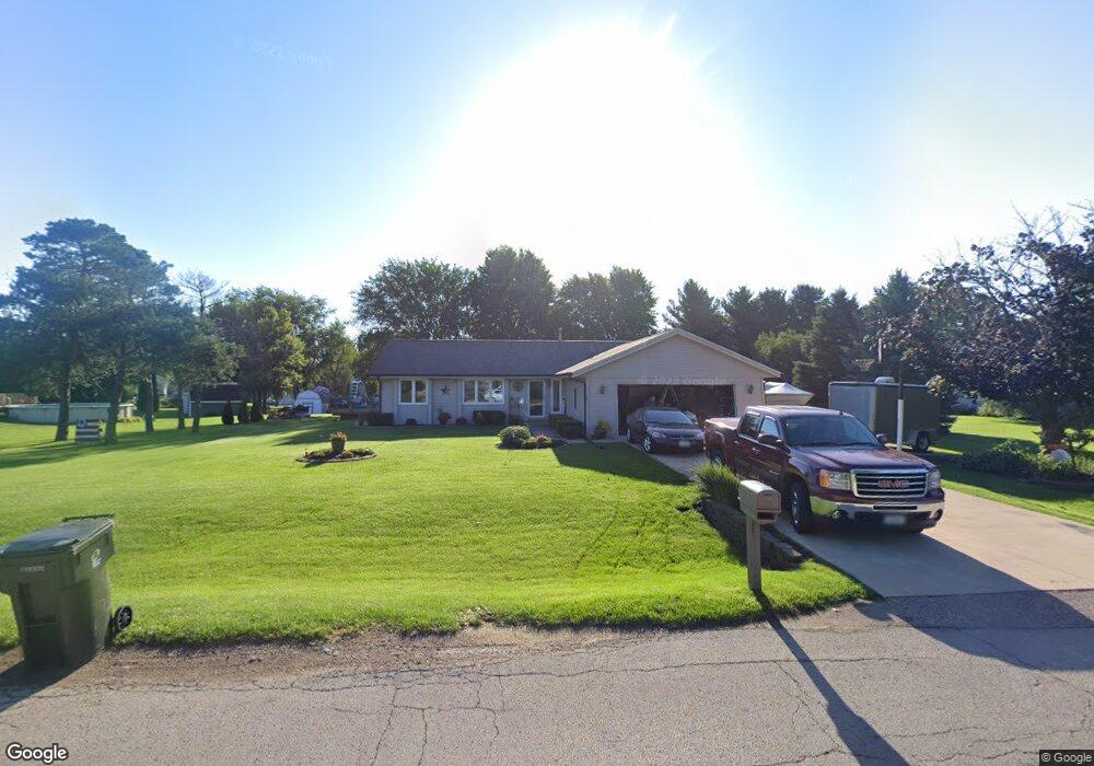
9733 Applegate Dr Roscoe, IL 61073
Estimated Value: $268,453 - $300,000
3
Beds
2
Baths
1,751
Sq Ft
$166/Sq Ft
Est. Value
About This Home
This home is located at 9733 Applegate Dr, Roscoe, IL 61073 and is currently estimated at $289,863, approximately $165 per square foot. 9733 Applegate Dr is a home located in Winnebago County with nearby schools including Olson Park Elementary School, Harlem Middle School, and Harlem High School.
Ownership History
Date
Name
Owned For
Owner Type
Purchase Details
Closed on
Apr 15, 2021
Sold by
Gille Corynne K
Bought by
Gille Kirk R and Gille Corynne K
Current Estimated Value
Home Financials for this Owner
Home Financials are based on the most recent Mortgage that was taken out on this home.
Original Mortgage
$100,000
Outstanding Balance
$75,137
Interest Rate
3.05%
Mortgage Type
New Conventional
Estimated Equity
$214,726
Purchase Details
Closed on
Sep 14, 2001
Sold by
James Jones and James Juliann
Bought by
Heitz Corynne K
Purchase Details
Closed on
Mar 26, 1992
Bought by
Heitz Corynne
Create a Home Valuation Report for This Property
The Home Valuation Report is an in-depth analysis detailing your home's value as well as a comparison with similar homes in the area
Home Values in the Area
Average Home Value in this Area
Purchase History
| Date | Buyer | Sale Price | Title Company |
|---|---|---|---|
| Gille Kirk R | -- | None Listed On Document | |
| Heitz Corynne K | -- | -- | |
| Heitz Corynne | $87,000 | -- |
Source: Public Records
Mortgage History
| Date | Status | Borrower | Loan Amount |
|---|---|---|---|
| Open | Gille Kirk R | $100,000 |
Source: Public Records
Tax History
| Year | Tax Paid | Tax Assessment Tax Assessment Total Assessment is a certain percentage of the fair market value that is determined by local assessors to be the total taxable value of land and additions on the property. | Land | Improvement |
|---|---|---|---|---|
| 2024 | $5,417 | $69,826 | $13,383 | $56,443 |
| 2023 | $5,140 | $62,012 | $11,885 | $50,127 |
| 2022 | $5,030 | $56,560 | $10,840 | $45,720 |
| 2021 | $4,738 | $52,604 | $10,082 | $42,522 |
| 2020 | $4,360 | $50,109 | $9,604 | $40,505 |
| 2019 | $4,461 | $47,997 | $9,199 | $38,798 |
| 2018 | $4,636 | $46,423 | $8,897 | $37,526 |
| 2017 | $4,652 | $45,150 | $8,653 | $36,497 |
| 2016 | $4,569 | $0 | $0 | $0 |
| 2015 | $4,533 | $43,478 | $8,333 | $35,145 |
| 2014 | $3,667 | $36,673 | $4,943 | $31,730 |
Source: Public Records
Map
Nearby Homes
- 6346 Smoke Tree Cir
- 9573 Twin Deer Run
- 6395 Greystone
- 7334 Hawthorne Ridge
- 9208 Sheringham Dr
- 5651 Thompson Dr
- 8451 Mitchell Rd
- 5518 White Pine Ln
- 0000 Joncey Dr
- 8686 Dutch Elm Ct
- 5488 Mahogany Ln
- 8535 Springwood Ct
- 5476 Ebonywood Ln
- 5383 Mahogany Ln
- 5790 Ada Dr
- 5421 Ebonywood Ln
- 10107 Atwood Rd
- 5410 Autumnash Ln
- 5647 Lidden Ln
- 8511 Fig Tree Ln
- 9711 Applegate Dr
- 9755 Applegate Dr
- 6577 Sutter Dr
- 6444 Upper Ridge Way
- 6589 Sutter Dr
- 9677 Applegate Dr
- 6515 Sutter Dr
- 9760 Applegate Dr
- 6565 Sutter Dr
- 6553 Sutter Dr
- 6447 Upper Ridge Way
- 6497 Sutter Dr
- 9782 Applegate Dr
- 6601 Sutter Dr
- 6436 Upper Ridge Way
- 9655 Applegate Dr
- 9662 Applegate Dr
- 6607 Sutter Dr
- 6401 Smoke Tree Cir
- 9804 Applegate Dr
Your Personal Tour Guide
Ask me questions while you tour the home.