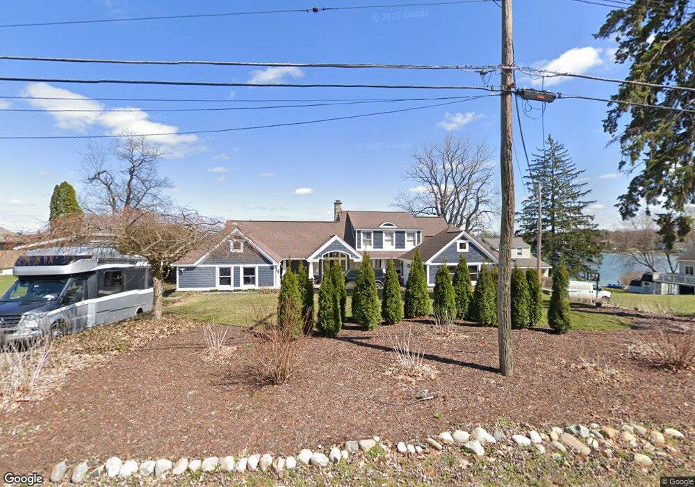
9738 Silverside South Lyon, MI 48178
Estimated Value: $966,000 - $1,163,000
4
Beds
4
Baths
2,346
Sq Ft
$435/Sq Ft
Est. Value
About This Home
This home is located at 9738 Silverside, South Lyon, MI 48178 and is currently estimated at $1,021,361, approximately $435 per square foot. 9738 Silverside is a home located in Livingston County with nearby schools including William A. Brummer Elementary School, Centennial Middle School, and South Lyon High School.
Ownership History
Date
Name
Owned For
Owner Type
Purchase Details
Closed on
Nov 13, 2009
Sold by
Prain Steven P and Prain Jennafer
Bought by
Prain James C
Current Estimated Value
Purchase Details
Closed on
Mar 5, 1999
Sold by
Showerman Steven and Showerman Francine A
Bought by
Warling Neal R and Warling Suzanne M
Home Financials for this Owner
Home Financials are based on the most recent Mortgage that was taken out on this home.
Original Mortgage
$616,250
Interest Rate
7.17%
Create a Home Valuation Report for This Property
The Home Valuation Report is an in-depth analysis detailing your home's value as well as a comparison with similar homes in the area
Home Values in the Area
Average Home Value in this Area
Purchase History
| Date | Buyer | Sale Price | Title Company |
|---|---|---|---|
| Prain James C | -- | -- | |
| Warling Neal R | $725,000 | American Title Co |
Source: Public Records
Mortgage History
| Date | Status | Borrower | Loan Amount |
|---|---|---|---|
| Previous Owner | Warling Neal R | $616,250 |
Source: Public Records
Tax History Compared to Growth
Tax History
| Year | Tax Paid | Tax Assessment Tax Assessment Total Assessment is a certain percentage of the fair market value that is determined by local assessors to be the total taxable value of land and additions on the property. | Land | Improvement |
|---|---|---|---|---|
| 2025 | $11,935 | $557,200 | $0 | $0 |
| 2024 | $8,040 | $517,700 | $0 | $0 |
| 2023 | $7,668 | $427,500 | $0 | $0 |
| 2022 | $9,746 | $427,200 | $0 | $0 |
| 2021 | $9,746 | $412,300 | $0 | $0 |
| 2020 | $9,697 | $465,900 | $0 | $0 |
| 2019 | $9,792 | $427,200 | $0 | $0 |
| 2018 | $9,659 | $411,900 | $0 | $0 |
| 2017 | $9,811 | $391,300 | $0 | $0 |
| 2016 | $9,954 | $328,900 | $0 | $0 |
| 2014 | $9,039 | $318,600 | $0 | $0 |
| 2012 | $9,039 | $303,700 | $0 | $0 |
Source: Public Records
Map
Nearby Homes
- 11390 Ridge Rd
- 11035 Silver View Ct
- 11047 Silver View Ct
- 11055 Silver View Ct
- 9044 Kemper Dr
- 0 Hillview Dr Unit 25052269
- 11108 Silver Lake Rd
- 10993 Stoney Point Dr
- 9112 Roger Scott Trail
- 0000 Stoney Point Unit 5
- 9736 Cross Creek Dr
- 11904 Moose Ridge Dr
- 11755 Shenandoah Dr Unit 159-4
- 10611 Lighthouse Point
- 10817 Cliffview Dr
- 11734 Shenandoah Dr Unit 3
- 11889 Shenandoah Dr Unit 3
- 12192 Doane Rd
- 10537 Oak Forest Dr
- 10512 Oak Forest Dr
- 9742 Silverside
- 9734 Silverside
- 9746 Silverside
- 9726 Silverside
- 9737 Silverside
- 9722 Silverside
- 9743 Silverside
- 9758 Silverside
- 9731 Silverside
- 9718 Silverside
- 9715 Silverside
- 9757 Silverside
- 11041 Tillson Dr
- 9762 Silverside
- 11033 Tillson Dr
- 9761 Marshall Rd
- 9714 Silverside
- 9766 Silverside
- 11048 Tillson Dr
- 9743 Marshall Rd