974 Ridge Rd Wethersfield, CT 06109
Estimated Value: $442,000 - $553,486
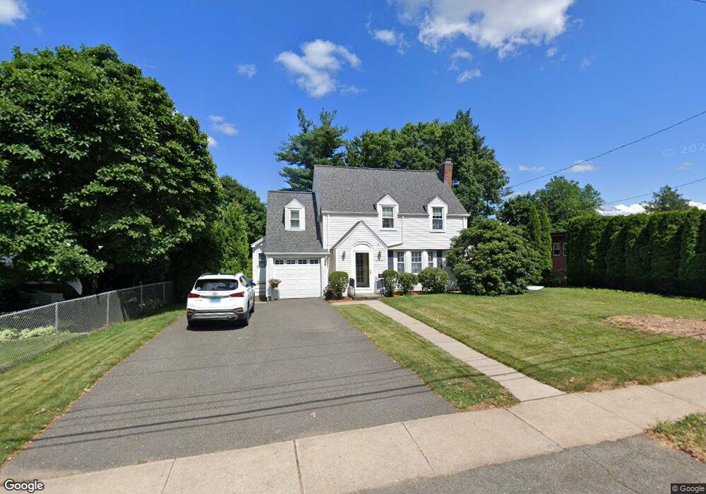
About This Home
This home is located at 974 Ridge Rd, Wethersfield, CT 06109 and is currently estimated at $496,872, approximately $207 per square foot. 974 Ridge Rd is a home located in Hartford County with nearby schools including Emerson-Williams School, Silas Deane Middle School, and Wethersfield High School.
Ownership History
We collect this data history from publicly available records. To have your information removed, we recommend requesting removal directly through your county’s website.
Purchase Details
Home Financials for this Owner
Home Financials are based on the most recent Mortgage that was taken out on this home.Purchase Details
Home Financials for this Owner
Home Financials are based on the most recent Mortgage that was taken out on this home.Purchase Details
Home Values in the Area
Average Home Value in this Area
Purchase History
We collect this data history from publicly available records. To have your information removed, we recommend requesting removal directly through your county’s website.
| Date | Buyer | Sale Price | Title Company |
|---|---|---|---|
| $162,000 | -- | ||
| $158,000 | -- | ||
| $155,000 | -- |
Mortgage History
We collect this data history from publicly available records. To have your information removed, we recommend requesting removal directly through your county’s website.
| Date | Status | Borrower | Loan Amount |
|---|---|---|---|
| Open | $50,000 | ||
| Open | $154,000 | ||
| Closed | $153,900 | ||
| Previous Owner | $134,300 |
Tax History
We collect this data history from publicly available records. To have your information removed, we recommend requesting removal directly through your county’s website.
| Year | Tax Paid | Tax Assessment Tax Assessment Total Assessment is a certain percentage of the fair market value that is determined by local assessors to be the total taxable value of land and additions on the property. | Land | Improvement |
|---|---|---|---|---|
| 2025 | $13,110 | $318,040 | $94,740 | $223,300 |
| 2024 | $8,919 | $206,370 | $64,450 | $141,920 |
| 2023 | $8,622 | $206,370 | $64,450 | $141,920 |
| 2022 | $8,422 | $205,020 | $64,450 | $140,570 |
| 2021 | $8,338 | $205,020 | $64,450 | $140,570 |
| 2020 | $8,342 | $205,020 | $64,450 | $140,570 |
| 2019 | $8,133 | $199,640 | $64,450 | $135,190 |
| 2018 | $8,376 | $205,400 | $64,100 | $141,300 |
| 2017 | $8,169 | $205,400 | $64,100 | $141,300 |
| 2016 | $7,673 | $199,100 | $64,100 | $135,000 |
| 2015 | $7,604 | $199,100 | $64,100 | $135,000 |
| 2014 | $6,121 | $166,600 | $64,100 | $102,500 |
Map
- 129 Midwell Rd
- 273 Dix Rd
- 80 Grist Mill Rd
- 43 Edward St
- 76 Collier Rd
- 46 Stonegate Dr
- 101 Collier Rd
- 742 Wolcott Hill Rd
- 59 Thornbush Rd
- 152 Surrey Dr
- 44 Beverly Rd
- 597 Wolcott Hill Rd
- 7 Barrington Dr Unit C
- 127 Stillwold Dr
- 32 Meadowgate St
- 22 Westwood Dr
- 107 Round Hill Rd
- 410 Westwood Hill
- 107 Coleman Rd
- 99 Westlook Rd
- 970 Ridge Rd
- 982 Ridge Rd
- 962 Ridge Rd
- 23 Grandview Terrace
- 15 Grandview Terrace
- 29 Grandview Terrace
- 9 Grandview Terrace
- 956 Ridge Rd
- 969 Ridge Rd
- 508 Brimfield Rd
- 41 Grandview Terrace
- 961 Ridge Rd
- 981 Ridge Rd
- 1000 Ridge Rd
- 16 Grandview Terrace
- 995 Ridge Rd
- 987 Ridge Rd
- 28 Grandview Terrace
- 480 Brimfield Rd
- 944 Ridge Rd
Ask me questions while you tour the home.