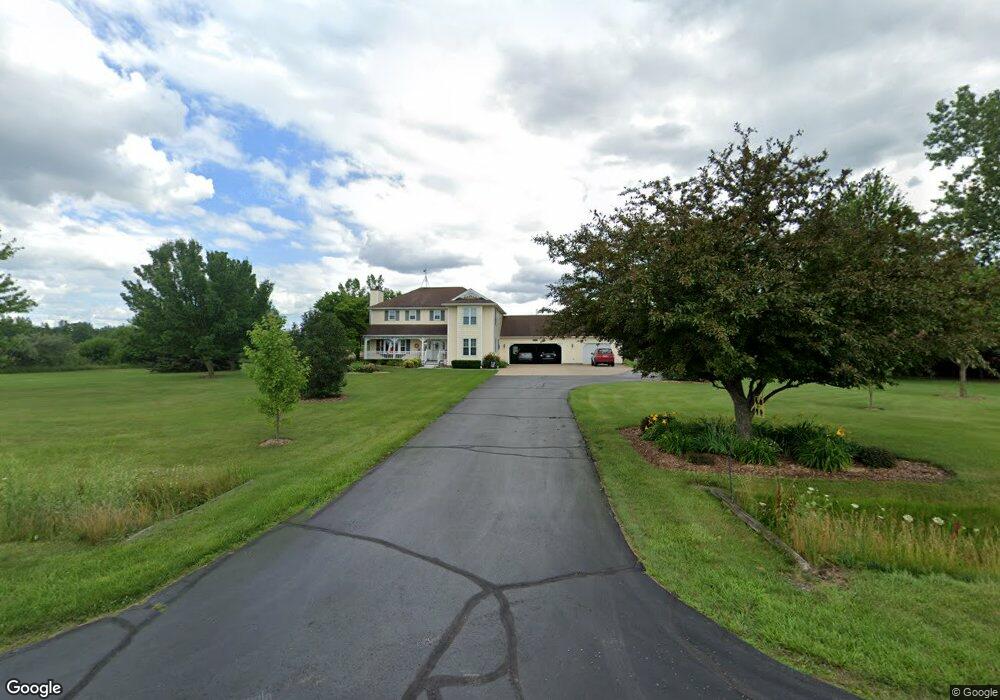
9745 Buck Rd Freeland, MI 48623
Estimated Value: $440,000 - $512,000
4
Beds
3
Baths
2,334
Sq Ft
$199/Sq Ft
Est. Value
About This Home
This home is located at 9745 Buck Rd, Freeland, MI 48623 and is currently estimated at $465,145, approximately $199 per square foot. 9745 Buck Rd is a home located in Saginaw County with nearby schools including Freeland Learning Center, Freeland Elementary School, and Freeland Middle/High School.
Ownership History
Date
Name
Owned For
Owner Type
Purchase Details
Closed on
Oct 3, 2014
Sold by
Terry Larry D and Terry Cheri J
Bought by
Larry D Terry And Cheri Terry Trust
Current Estimated Value
Purchase Details
Closed on
Jan 15, 2010
Sold by
Williamson David M and Williamson Laura D
Bought by
Terry Larry D
Home Financials for this Owner
Home Financials are based on the most recent Mortgage that was taken out on this home.
Original Mortgage
$208,587
Interest Rate
4.87%
Mortgage Type
FHA
Purchase Details
Closed on
Apr 29, 2003
Sold by
Buck Kenneth A and Buck Tammy S
Bought by
Williamson David M and Williamson Laura D
Create a Home Valuation Report for This Property
The Home Valuation Report is an in-depth analysis detailing your home's value as well as a comparison with similar homes in the area
Home Values in the Area
Average Home Value in this Area
Purchase History
| Date | Buyer | Sale Price | Title Company |
|---|---|---|---|
| Larry D Terry And Cheri Terry Trust | -- | -- | |
| Terry Larry D | $220,000 | -- | |
| Williamson David M | $234,000 | -- |
Source: Public Records
Mortgage History
| Date | Status | Borrower | Loan Amount |
|---|---|---|---|
| Previous Owner | Terry Larry D | $208,587 |
Source: Public Records
Tax History Compared to Growth
Tax History
| Year | Tax Paid | Tax Assessment Tax Assessment Total Assessment is a certain percentage of the fair market value that is determined by local assessors to be the total taxable value of land and additions on the property. | Land | Improvement |
|---|---|---|---|---|
| 2025 | $5,242 | $201,700 | $0 | $0 |
| 2024 | $1,529 | $182,100 | $0 | $0 |
| 2023 | $1,456 | $158,600 | $0 | $0 |
| 2022 | $4,293 | $147,900 | $0 | $0 |
| 2021 | $3,918 | $137,900 | $0 | $0 |
| 2020 | $3,799 | $130,300 | $0 | $0 |
| 2019 | $3,693 | $124,500 | $0 | $0 |
| 2018 | $1,270 | $120,200 | $0 | $0 |
| 2017 | $3,296 | $120,200 | $0 | $0 |
| 2016 | $3,270 | $113,400 | $0 | $0 |
| 2014 | -- | $112,400 | $0 | $97,000 |
| 2013 | -- | $110,600 | $0 | $0 |
Source: Public Records
Map
Nearby Homes
- 10399 Webster Rd
- 10585 Prairie View Ct
- 9924 Garner Ln
- 0 Foxtail Trail Unit 50182332
- 10832 Carter Rd
- 8599 Ashland Place
- 8657 Foxtail Trail
- 8630 Foxtail Trail
- 5749 11 Mile Rd
- 8535 Summer Ridge Dr
- 8421 Waxwing Dr
- 8884 Copper Ct
- 8442 Cottonwood Dr
- 8981 Highland Dr
- 8483 N River Rock River Rock Unit 8487
- 5 Willow Point Dr
- 9100 Brook Hollow Ln
- 9160 Brook Hollow Ln
- 10123 Hawk Dr
- 315 S 2nd St