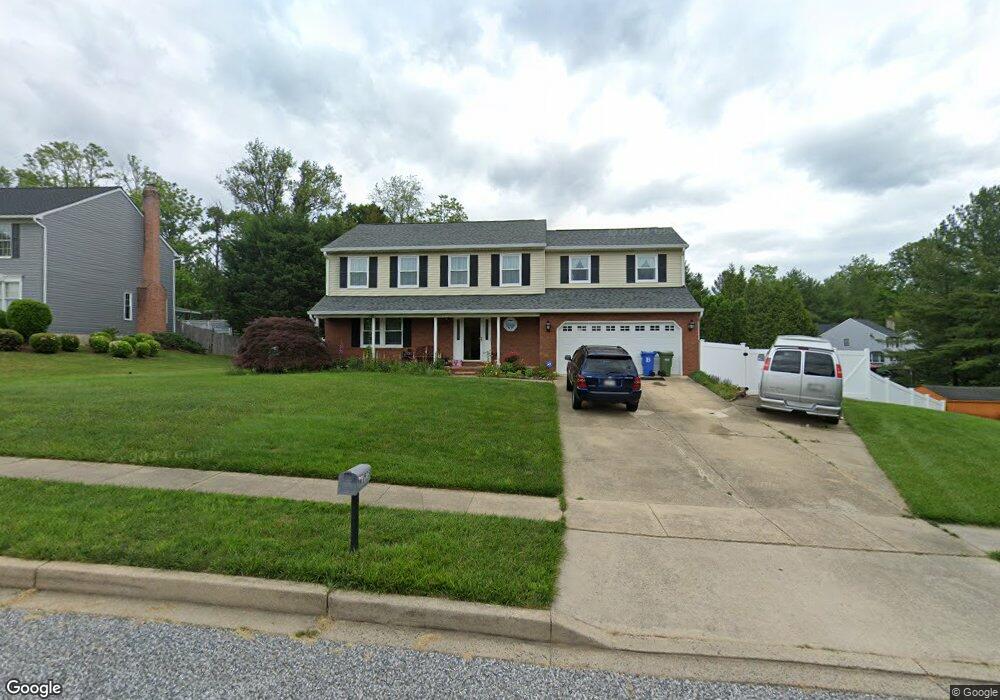
975 E Ring Factory Rd Bel Air, MD 21014
Estimated Value: $471,000 - $591,000
Studio
3
Baths
2,258
Sq Ft
$232/Sq Ft
Est. Value
About This Home
This home is located at 975 E Ring Factory Rd, Bel Air, MD 21014 and is currently estimated at $523,344, approximately $231 per square foot. 975 E Ring Factory Rd is a home located in Harford County with nearby schools including Homestead-Wakefield Elementary School, Bel Air Middle School, and Bel Air High School.
Ownership History
Date
Name
Owned For
Owner Type
Purchase Details
Closed on
Jan 9, 2024
Sold by
Demond Paul S and Demond Judy A
Bought by
Demond Paul S and Demond Judy A
Current Estimated Value
Purchase Details
Closed on
Nov 24, 1987
Sold by
Elite Homes Inc
Bought by
Demond Paul S and Demond Judy A
Home Financials for this Owner
Home Financials are based on the most recent Mortgage that was taken out on this home.
Original Mortgage
$132,700
Interest Rate
10.6%
Purchase Details
Closed on
Sep 22, 1987
Sold by
Bel Air Land Development Iii
Bought by
Elite Homes Inc
Purchase Details
Closed on
Jun 4, 1986
Sold by
Gerrett Company Inc The
Bought by
Bel Air Land Development Iii
Create a Home Valuation Report for This Property
The Home Valuation Report is an in-depth analysis detailing your home's value as well as a comparison with similar homes in the area
Home Values in the Area
Average Home Value in this Area
Purchase History
We collect this data history from publicly available records. To have your information removed, we recommend requesting removal directly through your county’s website.
| Date | Buyer | Sale Price | Title Company |
|---|---|---|---|
| Demond Paul S | -- | None Listed On Document | |
| Demond Paul S | -- | None Listed On Document | |
| Demond Paul S | $169,800 | -- | |
| Elite Homes Inc | $28,900 | -- | |
| Bel Air Land Development Iii | $716,400 | -- |
Source: Public Records
Mortgage History
We collect this data history from publicly available records. To have your information removed, we recommend requesting removal directly through your county’s website.
| Date | Status | Borrower | Loan Amount |
|---|---|---|---|
| Previous Owner | Demond Paul S | $132,700 |
Source: Public Records
Tax History
| Year | Tax Paid | Tax Assessment Tax Assessment Total Assessment is a certain percentage of the fair market value that is determined by local assessors to be the total taxable value of land and additions on the property. | Land | Improvement |
|---|---|---|---|---|
| 2025 | $3,595 | $417,700 | $114,600 | $303,100 |
| 2024 | $3,595 | $402,033 | $0 | $0 |
| 2023 | $3,455 | $386,367 | $0 | $0 |
| 2022 | $4,040 | $370,700 | $114,600 | $256,100 |
| 2021 | $2,248 | $359,267 | $0 | $0 |
| 2020 | $4,014 | $347,833 | $0 | $0 |
| 2019 | $3,882 | $336,400 | $120,900 | $215,500 |
| 2018 | $3,816 | $333,700 | $0 | $0 |
| 2017 | $3,785 | $336,400 | $0 | $0 |
| 2016 | -- | $328,300 | $0 | $0 |
| 2015 | $3,774 | $326,833 | $0 | $0 |
| 2014 | $3,774 | $325,367 | $0 | $0 |
Source: Public Records
Map
Nearby Homes
- 906 Featherstone Ct
- 900 Macphail Woods Crossing Unit 3A
- 863 Ellicott Dr
- 901 Macphail Woods Crossing Unit 4B
- 901 Macphail Woods Crossing Unit 3D
- 834 Ellicott Dr
- 102 Brandywine Place
- 718 Bedford Rd
- 932 Grosvenor Dr
- 1815 Selvin Dr Unit 204
- 1818 Selvin Dr Unit 301
- 934 Cheswold Ct
- 702 Chambers Cir
- 1603 Martha Ct Unit 101
- 718 Linwood Ave
- 204 Woodland Dr
- 906 Whispering Ridge Ln
- 1309 Sheridan Place Unit 99
- 1240 Chateau Green Ct
- 600 E Macphail Rd
- 973 E Ring Factory Rd
- 1013 E Macphail Rd
- 971 E Ring Factory Rd
- 920 Fallen Stone Ct
- 919 Fallen Stone Ct
- 969 E Ring Factory Rd
- 1017 E Macphail Rd
- 1028 E Macphail Rd
- 917 Fallen Stone Ct
- 967 E Ring Factory Rd
- 914 Meadow Ridge Ct
- 918 Fallen Stone Ct
- 1030 E Macphail Rd
- 1026 E Macphail Rd
- 423 E Ring Factory Rd
- 1019 E Macphail Rd
- 912 Meadow Ridge Ct
- 915 Fallen Stone Ct
- 1032 E Macphail Rd
- 418 Sunny View Rd
Your Personal Tour Guide
Ask me questions while you tour the home.