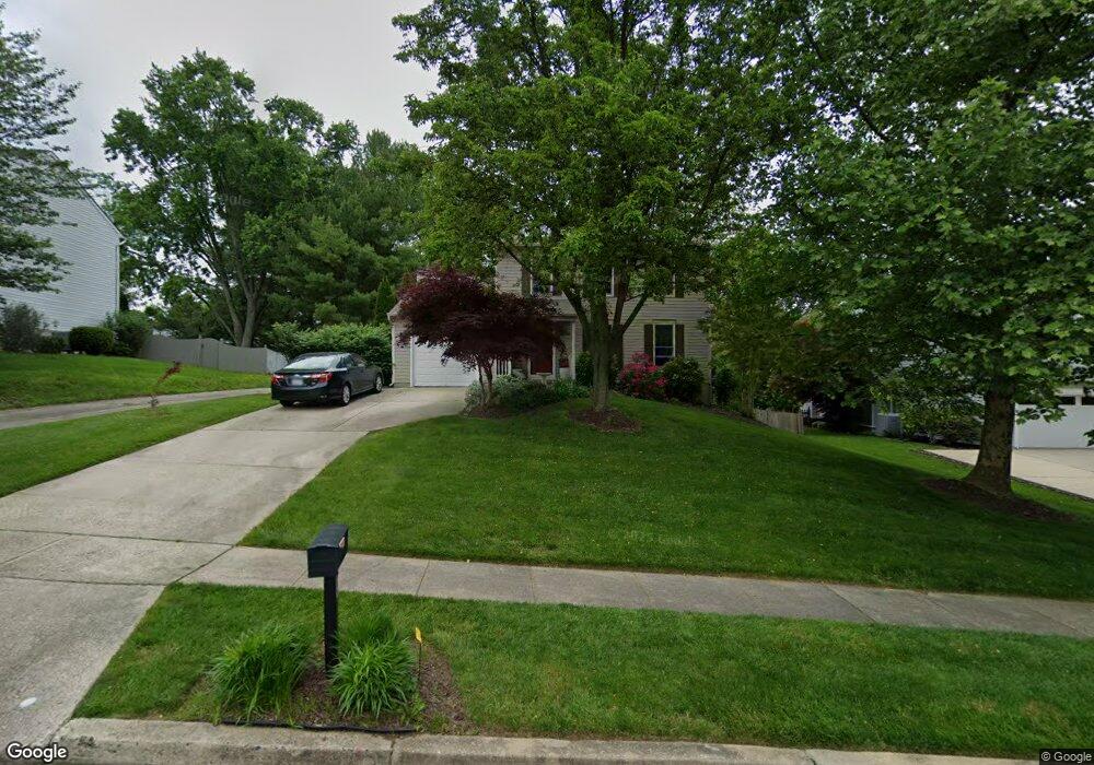
967 E Ring Factory Rd Bel Air, MD 21014
Estimated Value: $456,142 - $532,000
About This Home
This home is located at 967 E Ring Factory Rd, Bel Air, MD 21014 and is currently estimated at $486,536, approximately $282 per square foot. 967 E Ring Factory Rd is a home located in Harford County with nearby schools including Homestead-Wakefield Elementary School, Bel Air Middle School, and Bel Air High School.
Ownership History
We collect this data history from publicly available records. To have your information removed, we recommend requesting removal directly through your county’s website.
Purchase Details
Purchase Details
Home Financials for this Owner
Home Financials are based on the most recent Mortgage that was taken out on this home.Purchase Details
Home Financials for this Owner
Home Financials are based on the most recent Mortgage that was taken out on this home.Home Values in the Area
Average Home Value in this Area
Purchase History
We collect this data history from publicly available records. To have your information removed, we recommend requesting removal directly through your county’s website.
| Date | Buyer | Sale Price | Title Company |
|---|---|---|---|
| -- | None Listed On Document | ||
| $139,900 | -- | ||
| $34,000 | -- |
Mortgage History
We collect this data history from publicly available records. To have your information removed, we recommend requesting removal directly through your county’s website.
| Date | Status | Borrower | Loan Amount |
|---|---|---|---|
| Previous Owner | $132,905 | ||
| Previous Owner | $210,664 |
Tax History
We collect this data history from publicly available records. To have your information removed, we recommend requesting removal directly through your county’s website.
| Year | Tax Paid | Tax Assessment Tax Assessment Total Assessment is a certain percentage of the fair market value that is determined by local assessors to be the total taxable value of land and additions on the property. | Land | Improvement |
|---|---|---|---|---|
| 2025 | $4,008 | $381,700 | $112,200 | $269,500 |
| 2024 | $4,008 | $367,700 | $0 | $0 |
| 2023 | $3,855 | $353,700 | $0 | $0 |
| 2022 | $3,702 | $339,700 | $112,200 | $227,500 |
| 2021 | $3,661 | $328,467 | $0 | $0 |
| 2020 | $3,661 | $317,233 | $0 | $0 |
| 2019 | $3,531 | $306,000 | $120,400 | $185,600 |
| 2018 | $3,472 | $303,633 | $0 | $0 |
| 2017 | $3,445 | $306,000 | $0 | $0 |
| 2016 | $140 | $298,900 | $0 | $0 |
| 2015 | $3,252 | $298,667 | $0 | $0 |
| 2014 | $3,252 | $298,433 | $0 | $0 |
Map
- 863 Ellicott Dr
- 919 Jackson Blvd
- 900 Macphail Woods Crossing Unit 3A
- 901 Macphail Woods Crossing Unit 4B
- 814 N Pine Ridge Ct
- 902 Macphail Woods Crossing Unit 1E
- 902 Macphail Woods Crossing Unit 4J
- 906 Featherstone Ct
- 1813 Selvin Dr Unit 303
- 1421 Saratoga Dr
- 102 Brandywine Place
- 1815 Selvin Dr Unit 204
- 1818 Selvin Dr Unit 301
- 702 Chambers Cir
- 1604 Martha Ct Unit 201
- 1310 Scottsdale Dr Unit C
- 1603 Martha Ct Unit 101
- 718 Linwood Ave
- 1309 Sheridan Place Unit 99
- Lot 2 Carolina Ave
- 969 E Ring Factory Rd
- 963 E Ring Factory Rd
- 971 E Ring Factory Rd
- 965 E Ring Factory Rd
- 959 E Macphail Rd
- 914 Meadow Ridge Ct
- 973 E Ring Factory Rd
- 955 E Macphail Rd
- 959 E Ring Factory Rd
- 1026 E Macphail Rd
- 919 Fallen Stone Ct
- 915 Meadow Ridge Ct
- 957 E Macphail Rd
- 912 Meadow Ridge Ct
- 975 E Ring Factory Rd
- 957 E Ring Factory Rd
- 917 Fallen Stone Ct
- 912 Hedgerow Ct
- 913 Meadow Ridge Ct
- 1028 E Macphail Rd
Ask me questions while you tour the home.