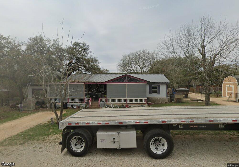
975 Research Canyon Lake, TX 78133
Estimated Value: $262,122 - $349,000
--
Bed
1
Bath
1,620
Sq Ft
$190/Sq Ft
Est. Value
About This Home
This home is located at 975 Research, Canyon Lake, TX 78133 and is currently estimated at $307,531, approximately $189 per square foot. 975 Research is a home located in Comal County with nearby schools including Mt Valley Elementary School, Mt Valley Middle School, and Canyon Lake High School.
Ownership History
Date
Name
Owned For
Owner Type
Purchase Details
Closed on
May 7, 2017
Sold by
Schartzer Sean
Bought by
Webb Annette
Current Estimated Value
Purchase Details
Closed on
Apr 5, 2017
Sold by
Webb Noreta and Schuman Brenda
Bought by
Webb Annette
Purchase Details
Closed on
Jan 26, 2017
Sold by
Gerdes Tristan Webb
Bought by
Webb Annette
Purchase Details
Closed on
Oct 26, 2016
Sold by
Nash Michael
Bought by
Webb Annette
Purchase Details
Closed on
Oct 3, 2016
Sold by
Nash Nathan
Bought by
Webb Annette
Purchase Details
Closed on
Sep 26, 2016
Sold by
Nash Susan
Bought by
Webb Annette
Create a Home Valuation Report for This Property
The Home Valuation Report is an in-depth analysis detailing your home's value as well as a comparison with similar homes in the area
Home Values in the Area
Average Home Value in this Area
Purchase History
| Date | Buyer | Sale Price | Title Company |
|---|---|---|---|
| Webb Annette | -- | None Available | |
| Webb Annette | -- | None Available | |
| Webb Annette | -- | None Available | |
| Webb Annette | -- | None Available | |
| Webb Annette | -- | None Available | |
| Webb Annette | -- | None Available |
Source: Public Records
Tax History Compared to Growth
Tax History
| Year | Tax Paid | Tax Assessment Tax Assessment Total Assessment is a certain percentage of the fair market value that is determined by local assessors to be the total taxable value of land and additions on the property. | Land | Improvement |
|---|---|---|---|---|
| 2025 | $321 | $168,240 | -- | -- |
| 2024 | $321 | $152,945 | -- | -- |
| 2023 | $321 | $139,041 | $0 | $0 |
| 2022 | $456 | $126,401 | -- | -- |
| 2021 | $2,058 | $114,910 | $25,210 | $89,700 |
| 2020 | $2,090 | $112,490 | $25,210 | $87,280 |
| 2019 | $2,432 | $130,850 | $25,210 | $105,640 |
| 2018 | $2,188 | $115,890 | $25,210 | $90,680 |
| 2017 | $2,287 | $122,100 | $25,210 | $96,890 |
| 2016 | $2,223 | $119,610 | $21,430 | $98,180 |
| 2015 | $621 | $107,890 | $21,430 | $86,460 |
| 2014 | $621 | $105,860 | $21,430 | $84,430 |
Source: Public Records
Map
Nearby Homes
- 1560 Roadrunner Ln
- 239 George Strait
- 1316 Lonesome
- 1031 Parton and 151 Reeves Rd
- 1193 Parton Rd
- 1004 Parton Rd
- 1012 Parton Rd
- 1252 Parton Rd
- 1456 Lonesome
- 151 Nighthawk Ln
- 355 Nighthawk Ct
- 355 & 375 Nighthawk Ct
- 520 Golden Eagle Loop
- 570 La Paloma Dr
- 162 Falcon Ct
- 1163 Lavaca
- 1080 Sorrel Creek Dr
- 381 Monarch
- 1332 Sorrel Creek Dr
- 399 Scenic Terrace Dr