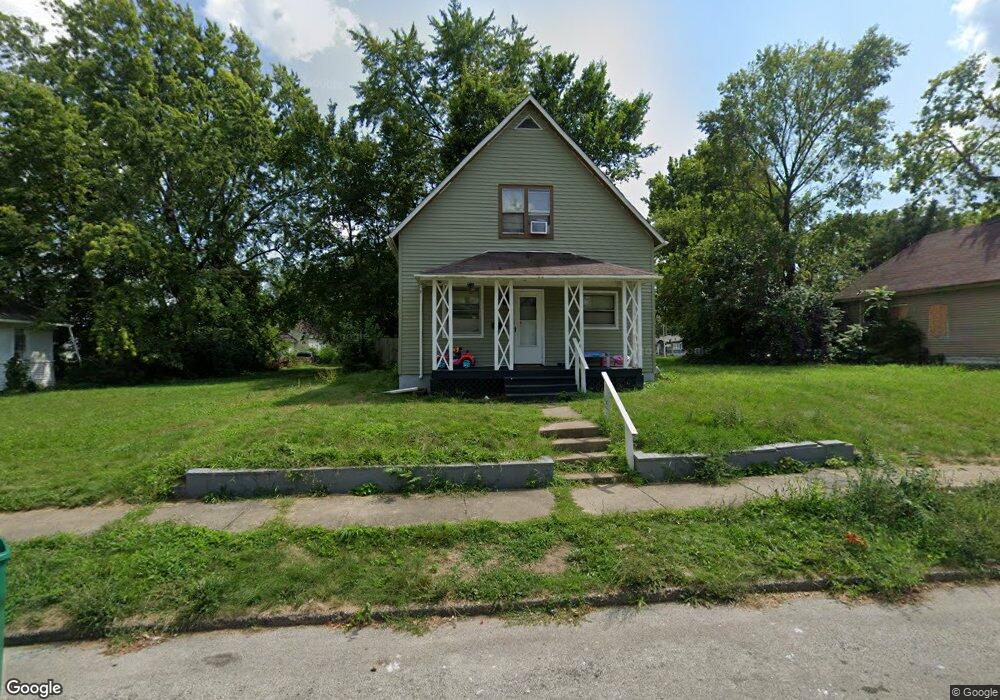
975 W View St Decatur, IL 62522
Garfield Park NeighborhoodEstimated Value: $31,000 - $43,000
3
Beds
1
Bath
2,192
Sq Ft
$17/Sq Ft
Est. Value
About This Home
This home is located at 975 W View St, Decatur, IL 62522 and is currently estimated at $37,097, approximately $16 per square foot. 975 W View St is a home located in Macon County with nearby schools including Stephen Decatur Middle School and Teen Challenge-Home For Girls.
Ownership History
Date
Name
Owned For
Owner Type
Purchase Details
Closed on
Jul 27, 2023
Sold by
Powers Askari
Bought by
Aliabadi Massoud
Current Estimated Value
Purchase Details
Closed on
Nov 9, 2017
Sold by
Stoneburg Edward F and Stoneburg Severly J
Bought by
Powers Askari
Purchase Details
Closed on
Mar 21, 2012
Sold by
Hooses Katherine and Simpson Rosty
Bought by
Farpoint Enterprises Llc
Purchase Details
Closed on
Jan 26, 2006
Sold by
Parsley John
Bought by
Butts Gerald L
Create a Home Valuation Report for This Property
The Home Valuation Report is an in-depth analysis detailing your home's value as well as a comparison with similar homes in the area
Home Values in the Area
Average Home Value in this Area
Purchase History
| Date | Buyer | Sale Price | Title Company |
|---|---|---|---|
| Aliabadi Massoud | -- | None Listed On Document | |
| Powers Askari | -- | -- | |
| Farpoint Enterprises Llc | $10,000 | None Available | |
| Butts Gerald L | -- | None Available | |
| Butts Geradl L | $28,000 | None Available |
Source: Public Records
Tax History Compared to Growth
Tax History
| Year | Tax Paid | Tax Assessment Tax Assessment Total Assessment is a certain percentage of the fair market value that is determined by local assessors to be the total taxable value of land and additions on the property. | Land | Improvement |
|---|---|---|---|---|
| 2024 | $369 | $3,808 | $437 | $3,371 |
| 2023 | $366 | $3,674 | $422 | $3,252 |
| 2022 | $354 | $3,460 | $390 | $3,070 |
| 2021 | $333 | $3,232 | $365 | $2,867 |
| 2020 | $328 | $3,083 | $349 | $2,734 |
| 2019 | $328 | $3,083 | $349 | $2,734 |
| 2018 | $341 | $3,247 | $199 | $3,048 |
| 2017 | $540 | $5,156 | $204 | $4,952 |
| 2016 | $550 | $5,209 | $206 | $5,003 |
| 2015 | $523 | $5,117 | $202 | $4,915 |
| 2014 | $563 | $5,872 | $202 | $5,670 |
| 2013 | $582 | $6,093 | $210 | $5,883 |
Source: Public Records
Map
Nearby Homes
- 1065 W Green St
- 837 W Grand Ave
- 917 N Wilder Ave
- 875 N Monroe St
- 1429 N Walnut Grove Ave
- 958 W William St
- 415 W Green St
- 844 N Edward St
- 254 N Pine St
- 1319 W Waggoner St
- 1451 W Marietta St
- 1545 N Monroe St
- 933 W Division St
- 609 W William St
- 1504 N Monroe St
- 1245 N Union St
- 717 W Prairie Ave Unit 2
- 1653 N Maple Ave
- 925 W Olive St
- 1005 W Main St