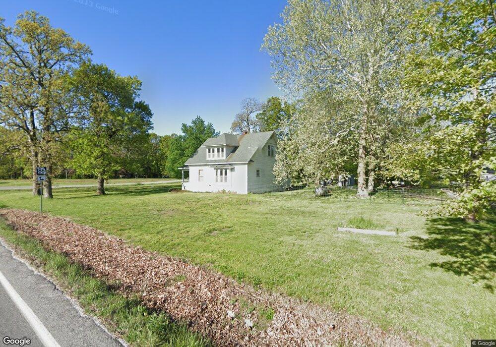
9754 E Highway 86 Neosho, MO 64850
Estimated Value: $212,013 - $231,000
3
Beds
2
Baths
1,379
Sq Ft
$162/Sq Ft
Est. Value
About This Home
This home is located at 9754 E Highway 86, Neosho, MO 64850 and is currently estimated at $224,003, approximately $162 per square foot. 9754 E Highway 86 is a home located in Newton County with nearby schools including Neosho High School.
Ownership History
Date
Name
Owned For
Owner Type
Purchase Details
Closed on
Jun 6, 2025
Sold by
Day Christopher and Day Dina
Bought by
Day Christopher and Day Dina
Current Estimated Value
Purchase Details
Closed on
Jul 3, 2019
Sold by
Robert Payton Levi and Robert Emily Megan
Bought by
Day Christopher and Day Dina
Home Financials for this Owner
Home Financials are based on the most recent Mortgage that was taken out on this home.
Original Mortgage
$63,988
Interest Rate
4%
Mortgage Type
New Conventional
Create a Home Valuation Report for This Property
The Home Valuation Report is an in-depth analysis detailing your home's value as well as a comparison with similar homes in the area
Purchase History
| Date | Buyer | Sale Price | Title Company |
|---|---|---|---|
| Day Christopher | -- | None Listed On Document | |
| Day Christopher | -- | None Listed On Document | |
| Day Christopher | $85,104 | None Listed On Document |
Source: Public Records
Mortgage History
| Date | Status | Borrower | Loan Amount |
|---|---|---|---|
| Previous Owner | Day Christopher | $63,988 |
Source: Public Records
Tax History
| Year | Tax Paid | Tax Assessment Tax Assessment Total Assessment is a certain percentage of the fair market value that is determined by local assessors to be the total taxable value of land and additions on the property. | Land | Improvement |
|---|---|---|---|---|
| 2024 | $1,095 | $19,020 | -- | -- |
| 2023 | $1,095 | $19,020 | $5,282 | $13,738 |
| 2022 | $1,095 | $18,560 | -- | -- |
| 2021 | $1,066 | $18,560 | $0 | $0 |
| 2020 | $1,019 | $17,820 | $0 | $0 |
| 2019 | $934 | $17,820 | $0 | $0 |
| 2018 | $565 | $10,680 | $0 | $0 |
| 2017 | $550 | $10,680 | $0 | $0 |
| 2016 | $550 | $10,430 | $0 | $0 |
| 2015 | -- | $10,250 | $0 | $0 |
| 2014 | -- | $10,250 | $0 | $0 |
Source: Public Records
Map
Nearby Homes
- 21+/- Acres Goldfinch Rd
- 000 Goldfinch Rd
- 000 Memory Ln
- TBD Memory Ln
- 10514 Gazelle Dr
- 18284 B Gazelle Dr
- 0000 Gazelle Rd
- 14830 Heron Dr
- Tbd Iris Rd
- Tract 3 Iris Rd
- Tract 1 Iris Rd
- 10559 Norway Rd
- 12228 Lauren Ln
- 12629 Kentucky Rd
- Tract 2 SW Swc 86 Highway & Kodiak Rd
- 13504 Jay Dr
- 15092 Goldfinch Rd
- 13844 Jay Dr
- 11834 Norway Rd
- TR 2 Swc 86 Hwy & Kodiak Rd
- 9754 E Highway 86
- 9737 State Highway 86
- 9737 E Highway 86
- 10089 Kapok Dr
- 9689 E Highway 86
- 9663 State Highway 86
- 9663 E Highway 86
- 9900 Leander Ln
- 9981 Leander Ln
- 10207 Kentucky Rd
- 9969 E Highway 86
- 10108 Kentucky Rd
- 9457 E Highway 86
- 9398 E Highway 86
- 13021 Hereford Rd
- 11921 Highway Nn
- 8282 E Highway 86
- 13034 Hereford Rd
- 10341 E Highway 86
- 11863 Highway Nn
Your Personal Tour Guide
Ask me questions while you tour the home.