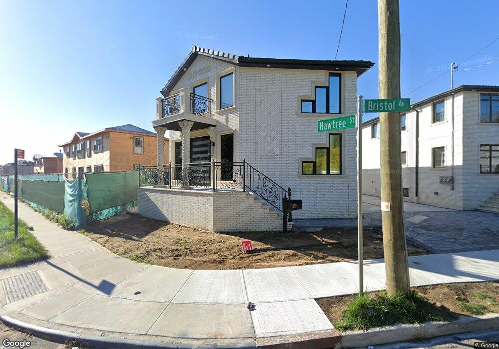
9756 Bristol Ave Ozone Park, NY 11417
Ozone Park NeighborhoodEstimated Value: $961,000 - $1,154,853
--
Bed
--
Bath
2,834
Sq Ft
$376/Sq Ft
Est. Value
About This Home
This home is located at 9756 Bristol Ave, Ozone Park, NY 11417 and is currently estimated at $1,066,713, approximately $376 per square foot. 9756 Bristol Ave is a home with nearby schools including P.S./M.S. 146 Howard Beach, Robert H. Goddard High School, and John Adams High School.
Ownership History
Date
Name
Owned For
Owner Type
Purchase Details
Closed on
Feb 7, 2022
Sold by
Bristol Ozone Llc
Bought by
Bristol Ozone Llc
Current Estimated Value
Purchase Details
Closed on
Aug 4, 2021
Sold by
Sita Ioan
Bought by
Bristol Ozone Llc
Purchase Details
Closed on
Aug 22, 2013
Sold by
Schiavone Michele
Bought by
Sita Ioan
Purchase Details
Closed on
May 31, 2004
Sold by
Schiavone Michele
Bought by
Schiavone Michele
Create a Home Valuation Report for This Property
The Home Valuation Report is an in-depth analysis detailing your home's value as well as a comparison with similar homes in the area
Home Values in the Area
Average Home Value in this Area
Purchase History
| Date | Buyer | Sale Price | Title Company |
|---|---|---|---|
| Bristol Ozone Llc | -- | -- | |
| Bristol Ozone Llc | -- | -- | |
| Bristol Ozone Llc | -- | -- | |
| Bristol Ozone Llc | -- | -- | |
| Sita Ioan | $55,000 | -- | |
| Sita Ioan | $55,000 | -- | |
| Schiavone Michele | -- | -- | |
| Schiavone Michele | -- | -- |
Source: Public Records
Tax History Compared to Growth
Tax History
| Year | Tax Paid | Tax Assessment Tax Assessment Total Assessment is a certain percentage of the fair market value that is determined by local assessors to be the total taxable value of land and additions on the property. | Land | Improvement |
|---|---|---|---|---|
| 2025 | $9,779 | $51,611 | $10,683 | $40,928 |
| 2024 | $9,779 | $48,690 | $12,079 | $36,611 |
| 2023 | $7,754 | $38,179 | $5,479 | $32,700 |
| 2022 | $774 | $10,320 | $10,320 | $0 |
| 2021 | $666 | $10,320 | $10,320 | $0 |
| 2020 | $614 | $11,460 | $11,460 | $0 |
| 2019 | $624 | $11,460 | $11,460 | $0 |
| 2018 | $603 | $2,956 | $2,956 | $0 |
| 2017 | $569 | $2,791 | $2,791 | $0 |
| 2016 | $527 | $2,791 | $2,791 | $0 |
| 2015 | $318 | $2,487 | $2,487 | $0 |
| 2014 | $318 | $2,487 | $2,487 | $0 |
Source: Public Records
Map
Nearby Homes
- 96-36 149th Ave
- 98-29 Albert Rd
- 137-21 Centreville St
- 150-06 Hawtree St
- 150-15 Hawtree St
- 96-15 149th Ave
- 150-17 Hawtree St
- 9704 Pitkin Ave
- 150-21 Hawtree St
- 150-25 Hawtree St
- 150-29 Hawtree St
- 150-33 Hawtree St
- 150-45 Centerville St Unit 3B
- 150-19 95th St Unit 3
- 94- 24 Magnolia Ct Unit 3A
- 94-02 149th Ave
- 13421 Hawtree St
- 95-18 Linden Blvd
- 135-16 95th St
- 13318 Centreville St
- 9752 Bristol Ave
- 9748 Bristol Ave
- 9751 Bristol Ave
- 53-18 149 Ave
- 9742 Bristol Ave
- 98-45 Bristol Ave Unit 2
- 98-45 Bristol Ave
- 9749 Bristol Ave
- 9755 Eckford Ave
- 9751 Eckford Ave
- 9747 Eckford Ave
- 9845 Bristol Ave
- 53-18 Bristol Ave
- 9745 Eckford Ave
- 97-47 Eckford Ave
- 9743 Eckford Ave
- 97-41 Eckford Ave
- 14942 Hawtree St
- 9738 Bristol Ave
- 9741 Eckford Ave