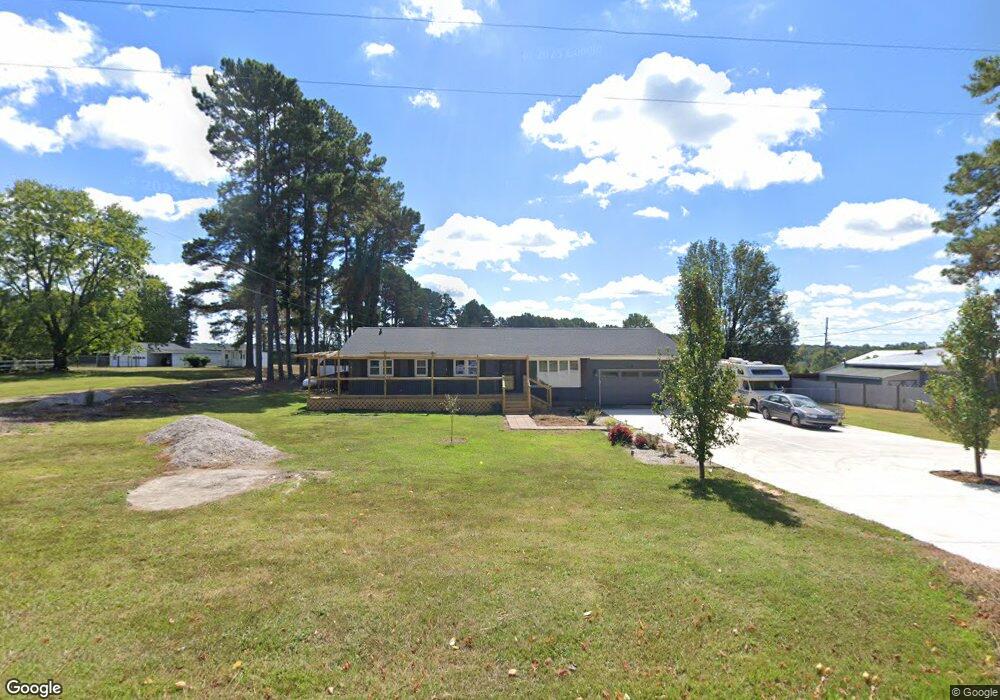
976 Ronald Tharrington Rd Louisburg, NC 27549
Estimated Value: $267,000 - $377,000
3
Beds
3
Baths
1,772
Sq Ft
$172/Sq Ft
Est. Value
About This Home
This home is located at 976 Ronald Tharrington Rd, Louisburg, NC 27549 and is currently estimated at $304,627, approximately $171 per square foot. 976 Ronald Tharrington Rd is a home located in Franklin County with nearby schools including Louisburg Elementary School, Terrell Lane Middle School, and Louisburg High School.
Ownership History
Date
Name
Owned For
Owner Type
Purchase Details
Closed on
Nov 1, 2015
Sold by
Mcclurg Marilyn
Bought by
Swanson Robert
Current Estimated Value
Home Financials for this Owner
Home Financials are based on the most recent Mortgage that was taken out on this home.
Original Mortgage
$65,000
Outstanding Balance
$26,639
Interest Rate
3.78%
Mortgage Type
Purchase Money Mortgage
Estimated Equity
$277,988
Purchase Details
Closed on
Aug 31, 2006
Sold by
Centex Home Equity Company Llc
Bought by
Mcclurg Robert A and Mcclurg Marilyn
Home Financials for this Owner
Home Financials are based on the most recent Mortgage that was taken out on this home.
Original Mortgage
$47,500
Interest Rate
6.67%
Mortgage Type
New Conventional
Create a Home Valuation Report for This Property
The Home Valuation Report is an in-depth analysis detailing your home's value as well as a comparison with similar homes in the area
Home Values in the Area
Average Home Value in this Area
Purchase History
| Date | Buyer | Sale Price | Title Company |
|---|---|---|---|
| Swanson Robert | $65,000 | None Available | |
| Mcclurg Robert A | $50,000 | None Available |
Source: Public Records
Mortgage History
| Date | Status | Borrower | Loan Amount |
|---|---|---|---|
| Open | Swanson Robert | $65,000 | |
| Previous Owner | Mcclurg Robert A | $47,500 |
Source: Public Records
Tax History Compared to Growth
Tax History
| Year | Tax Paid | Tax Assessment Tax Assessment Total Assessment is a certain percentage of the fair market value that is determined by local assessors to be the total taxable value of land and additions on the property. | Land | Improvement |
|---|---|---|---|---|
| 2025 | $2,390 | $378,470 | $43,160 | $335,310 |
| 2024 | $1,383 | $211,250 | $43,160 | $168,090 |
| 2023 | $1,233 | $127,260 | $18,470 | $108,790 |
| 2022 | $1,223 | $127,260 | $18,470 | $108,790 |
| 2021 | $1,236 | $127,260 | $18,470 | $108,790 |
| 2020 | $1,230 | $127,260 | $18,470 | $108,790 |
| 2019 | $1,217 | $127,260 | $18,470 | $108,790 |
| 2018 | $1,215 | $127,260 | $18,470 | $108,790 |
| 2017 | $1,060 | $100,220 | $15,390 | $84,830 |
| 2016 | $1,095 | $100,220 | $15,390 | $84,830 |
| 2015 | $1,090 | $100,220 | $15,390 | $84,830 |
| 2014 | $1,012 | $100,220 | $15,390 | $84,830 |
Source: Public Records
Map
Nearby Homes
- 45 Leisure Ln
- 55 Leisure Ln
- 70 Leisure Ln
- 376 T K Allen Rd
- 109 Drew St
- 7.69 Acres N Carolina 561
- 23.20 Acre N Carolina 561
- 10.26 Acre N Carolina 561
- 491 Nc 56 Hwy E
- 311 Nc 56 Hwy E
- 0-0 Halifax Rd
- 191 Nc 56 Hwy E
- 592 Perdues Rd
- 125 Davis St
- 126 Person St
- 612 N Main St
- 121 Tanglewood Dr
- 150 Alston Pruitt Rd
- 604 N Main St
- 209 Tanglewood Dr
- 973 Ronald Tharrington Rd
- 955 Ronald Tharrington Rd
- 55 Branch Ct
- 55 Branch Ct Unit 9
- 979 Ronald Tharrington Rd
- 914 Ronald Tharrington Rd
- 894 Ronald Tharrington Rd
- 1050 Ronald Tharrington Rd
- 884 Ronald Tharrington Rd
- 49 Huntington Rd
- 30 Branch Ct
- 65 Huntington Rd
- 45 Branch Ct
- 50 Branch Ct
- Lot 10 Branch Ct
- Lot 09 Branch Ct
- Lot 33 Branch Ct
- Lot 10 Branch Ct Unit 9
- Lot 33 Branch Ct Unit 33
- Lot 09 Branch Ct Unit 9