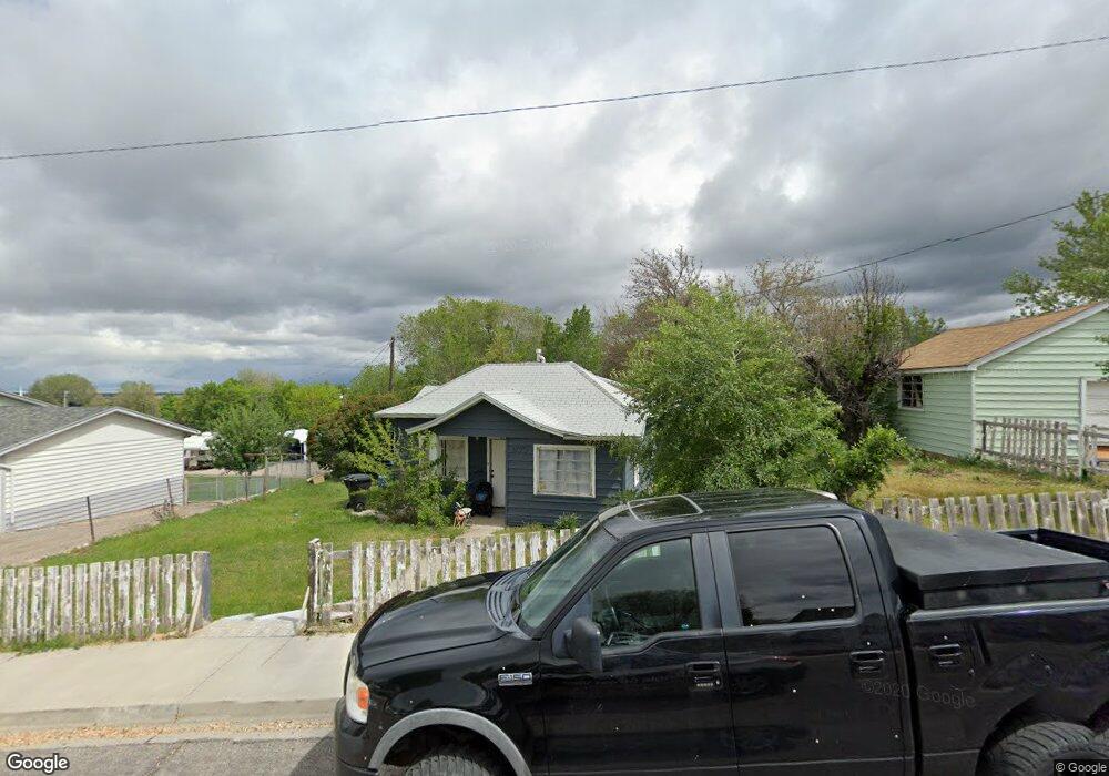
977 E 200 N Spanish Fork, UT 84660
Estimated Value: $432,000 - $478,000
3
Beds
1
Bath
1,300
Sq Ft
$348/Sq Ft
Est. Value
About This Home
This home is located at 977 E 200 N, Spanish Fork, UT 84660 and is currently estimated at $452,326, approximately $347 per square foot. 977 E 200 N is a home located in Utah County with nearby schools including Larsen Elementary School, Spanish Fork Jr High School, and Spanish Fork High School.
Ownership History
Date
Name
Owned For
Owner Type
Purchase Details
Closed on
Nov 20, 2025
Sold by
Fausett Zachary James
Bought by
Fausett Zachary James and Everett Maranda
Current Estimated Value
Home Financials for this Owner
Home Financials are based on the most recent Mortgage that was taken out on this home.
Original Mortgage
$260,000
Outstanding Balance
$259,510
Interest Rate
6.3%
Mortgage Type
New Conventional
Estimated Equity
$192,816
Purchase Details
Closed on
Mar 27, 2024
Sold by
Everett Cyruss W
Bought by
Fausett Zachary and Everett Maranda
Purchase Details
Closed on
Mar 6, 2024
Sold by
Everett Cyruss Wynn
Bought by
Everett Zachary and Everett Maranda
Purchase Details
Closed on
Jun 28, 1996
Sold by
Webster Wallace E and Webster Sharron L
Bought by
Everett Cyruss W
Home Financials for this Owner
Home Financials are based on the most recent Mortgage that was taken out on this home.
Original Mortgage
$95,000
Interest Rate
8.09%
Create a Home Valuation Report for This Property
The Home Valuation Report is an in-depth analysis detailing your home's value as well as a comparison with similar homes in the area
Home Values in the Area
Average Home Value in this Area
Purchase History
| Date | Buyer | Sale Price | Title Company |
|---|---|---|---|
| Fausett Zachary James | -- | First American Title Insurance | |
| Fausett Zachary James | -- | First American Title Insurance | |
| Fausett Zachary | -- | None Listed On Document | |
| Everett Zachary | -- | None Listed On Document | |
| Everett Cyruss W | -- | Provo Land Title |
Source: Public Records
Mortgage History
| Date | Status | Borrower | Loan Amount |
|---|---|---|---|
| Open | Fausett Zachary James | $260,000 | |
| Previous Owner | Everett Cyruss W | $95,000 |
Source: Public Records
Tax History
| Year | Tax Paid | Tax Assessment Tax Assessment Total Assessment is a certain percentage of the fair market value that is determined by local assessors to be the total taxable value of land and additions on the property. | Land | Improvement |
|---|---|---|---|---|
| 2025 | $1,674 | $195,415 | -- | -- |
| 2024 | $1,674 | $172,535 | $0 | $0 |
| 2023 | $1,669 | $172,260 | $0 | $0 |
| 2022 | $1,782 | $180,345 | $0 | $0 |
| 2021 | $1,516 | $245,500 | $96,100 | $149,400 |
| 2020 | $1,364 | $214,700 | $80,100 | $134,600 |
| 2019 | $1,190 | $197,100 | $80,100 | $117,000 |
| 2018 | $1,136 | $181,800 | $80,100 | $101,700 |
| 2017 | $1,275 | $92,510 | $0 | $0 |
| 2016 | $893 | $75,845 | $0 | $0 |
| 2015 | $812 | $68,090 | $0 | $0 |
| 2014 | $758 | $63,800 | $0 | $0 |
Source: Public Records
Map
Nearby Homes
- 284 N 1000 E
- 306 N 1070 E
- 306 N 1070 E Unit 17
- 274 N 1070 E Unit 14
- 299 N 1070 E Unit 8
- 212 N 1070 E Unit 9
- 224 N 1070 E Unit 10
- 314 N 1070 E
- 998 E 260 N Unit 16
- 992 E 260 N Unit 15
- 265 N 800 E
- 136 N 1120 E
- 973 E 60 S
- 453 N 1210 E
- 1025 E 360 N Unit 5
- 1022 E 360 N Unit 27
- 991 E 360 N Unit 8
- 679 E 400 N
- 1074 E 660 N
- 1238 E 100 S
Your Personal Tour Guide
Ask me questions while you tour the home.