Estimated Value: $304,010 - $317,000
3
Beds
3
Baths
1,826
Sq Ft
$170/Sq Ft
Est. Value
About This Home
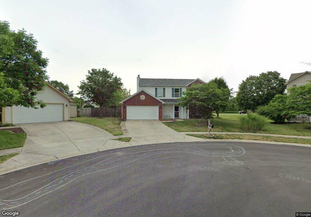
This home is located at 978 Port Cir, Avon, IN 46123 and is currently estimated at $310,003, approximately $169 per square foot. 978 Port Cir is a home located in Hendricks County with nearby schools including Maple Elementary School, White Oak Elementary School, and Avon Middle School North.
Ownership History
Date
Name
Owned For
Owner Type
Purchase Details
Closed on
Apr 15, 2022
Sold by
Bentley Rhobie E
Bought by
Bentley Paul R
Current Estimated Value
Purchase Details
Closed on
Oct 31, 2012
Sold by
Barrett Ashley and Werner Ashley
Bought by
Barrett Ryan and Barrett Ashley
Home Financials for this Owner
Home Financials are based on the most recent Mortgage that was taken out on this home.
Original Mortgage
$124,200
Interest Rate
3.35%
Mortgage Type
New Conventional
Purchase Details
Closed on
Oct 24, 2008
Sold by
Hare Kurt D and Hare Heather M
Bought by
Werner Ashley
Home Financials for this Owner
Home Financials are based on the most recent Mortgage that was taken out on this home.
Original Mortgage
$128,150
Interest Rate
5.95%
Mortgage Type
New Conventional
Create a Home Valuation Report for This Property
The Home Valuation Report is an in-depth analysis detailing your home's value as well as a comparison with similar homes in the area
Home Values in the Area
Average Home Value in this Area
Purchase History
| Date | Buyer | Sale Price | Title Company |
|---|---|---|---|
| Bentley Paul R | -- | None Listed On Document | |
| Barrett Ryan | -- | Security Title Services | |
| Werner Ashley | -- | None Available |
Source: Public Records
Mortgage History
| Date | Status | Borrower | Loan Amount |
|---|---|---|---|
| Previous Owner | Barrett Ryan | $124,200 | |
| Previous Owner | Werner Ashley | $128,150 |
Source: Public Records
Tax History Compared to Growth
Tax History
| Year | Tax Paid | Tax Assessment Tax Assessment Total Assessment is a certain percentage of the fair market value that is determined by local assessors to be the total taxable value of land and additions on the property. | Land | Improvement |
|---|---|---|---|---|
| 2024 | $1,980 | $232,200 | $37,300 | $194,900 |
| 2023 | $1,759 | $216,700 | $37,300 | $179,400 |
| 2022 | $1,740 | $205,300 | $37,300 | $168,000 |
| 2021 | $1,303 | $171,100 | $37,300 | $133,800 |
| 2020 | $1,176 | $162,700 | $37,300 | $125,400 |
| 2019 | $943 | $147,900 | $30,800 | $117,100 |
| 2018 | $998 | $146,200 | $30,800 | $115,400 |
| 2017 | $792 | $140,000 | $29,300 | $110,700 |
| 2016 | $775 | $136,500 | $29,300 | $107,200 |
| 2014 | $676 | $124,600 | $26,500 | $98,100 |
Source: Public Records
Map
Nearby Homes
- 8532 Charlotte Ct
- 8505 E County Road 100 N
- 793 Port Dr
- 958 Kitner Ave
- 546 Corbin Way
- 8405 Anderson Cir
- 1189 Kinross Dr
- 8626 Golden Falls Cir
- 729 N County Road 900 E
- 811 Stone Trace Ct
- 8287 Falkirk Dr
- 1451 Red Dunes Run
- 8275 Locke Cir
- 486 Hyannis Dr
- 8178 Captain Dr
- 8607 Redditch Dr
- 1218 Bedford Dr
- 8094 Wesleyan Dr
- 8080 Wesleyan Dr
- 8083 Wesleyan Dr