978 State Route 72 N Cedarville, OH 45314
Estimated payment $3,889/month
Highlights
- Hot Property
- No HOA
- Patio
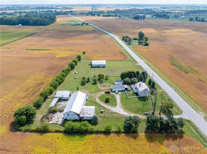
- 20.75 Acre Lot
- 4 Car Detached Garage
- Bathroom on Main Level
About This Home
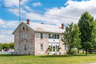
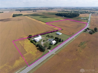
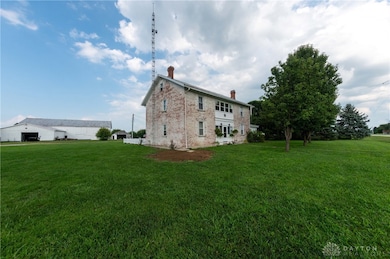
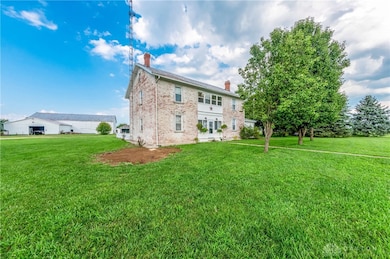
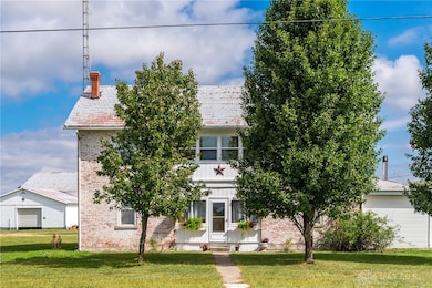
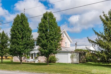
Welcome to the historic Evans Farm, known locally as “Doc Evans,” a rare opportunity to own a piece of Ohio history. Built circa 1854 by the Shigley family and later home to A.B. “Doc” Evans, an influential figure in Ohio agriculture. This stately two-story brick farmhouse sits on 20.75 acres in the Greeneview School District. The 3,516 sqft home offers 4–6 bedrooms, 2 full baths, parquet oak hardwood floors, and a beautifully remodeled kitchen with granite pegmatite countertops and slate flooring. Warmth and character flow through the breakfast and dining rooms, family room with Vermont Castings wood stove, and enclosed porches, while modern comforts include updated HVAC, whole-house A/C, and a reverse osmosis water system. A 12x24 heated/cooled art or music studio with kitchenette, a two-car garage with workshop, and multiple barns and outbuildings including a 40x88 main barn with stalls and hay storage, a 57x60 pole building with pull-through for equipment, and livestock facilities make this property ideal for farming, hobbies, or multi-use living. The land features 15 acres of tillable farmland (CAUV tax benefit, generating $3,520 annual rent), 1.6 acres of fenced pasture, and a charming orchard with apple, peach, pear, and cherry trees. The seller is motivated, having already secured a new home, and is open to parceling off the land south of the residence. With its rich history, agricultural potential, and flexible opportunities, this remarkable property is being sold as-is and awaits its next steward.
Home Details
Home Type
- Single Family
Est. Annual Taxes
- $4,629
Year Built
- 1854
Lot Details
- 20.75 Acre Lot
- Fenced
- Zoning described as Agricultural
Parking
- 4 Car Detached Garage
Home Design
- Brick Exterior Construction
Interior Spaces
- 3,482 Sq Ft Home
- 2-Story Property
- Ceiling Fan
- Wood Burning Fireplace
- Crawl Space
Kitchen
- Range
- Dishwasher
- Kitchen Island
Bedrooms and Bathrooms
- 5 Bedrooms
- Bathroom on Main Level
- 2 Full Bathrooms
Laundry
- Dryer
- Washer
Outdoor Features
- Patio
- Shed
Utilities
- Central Air
- Heating System Uses Propane
- Heat Pump System
- 220 Volts in Garage
- Well
- Gas Water Heater
- Septic Tank
- Septic System
Community Details
- No Home Owners Association
Listing and Financial Details
- Assessor Parcel Number H22000100150001500
Map
Home Values in the Area
Average Home Value in this Area
Tax History
| Year | Tax Paid | Tax Assessment Tax Assessment Total Assessment is a certain percentage of the fair market value that is determined by local assessors to be the total taxable value of land and additions on the property. | Land | Improvement |
|---|---|---|---|---|
| 2024 | $4,629 | $158,670 | $67,390 | $91,280 |
| 2023 | $4,629 | $158,670 | $67,390 | $91,280 |
| 2022 | $3,679 | $121,390 | $56,200 | $65,190 |
| 2021 | $3,715 | $121,390 | $56,200 | $65,190 |
| 2020 | $3,698 | $121,390 | $56,200 | $65,190 |
| 2019 | $3,781 | $108,750 | $49,570 | $59,180 |
| 2018 | $3,789 | $108,750 | $49,570 | $59,180 |
| 2017 | $3,675 | $108,750 | $49,570 | $59,180 |
| 2016 | $3,767 | $101,340 | $44,960 | $56,380 |
| 2015 | $3,753 | $101,340 | $44,960 | $56,380 |
| 2014 | $3,637 | $101,340 | $44,960 | $56,380 |
Property History
| Date | Event | Price | List to Sale | Price per Sq Ft |
|---|---|---|---|---|
| 11/02/2025 11/02/25 | Price Changed | $667,900 | -1.0% | $192 / Sq Ft |
| 09/24/2025 09/24/25 | For Sale | $674,900 | -- | $194 / Sq Ft |
Purchase History
| Date | Type | Sale Price | Title Company |
|---|---|---|---|
| Limited Warranty Deed | $182,100 | None Available | |
| Sheriffs Deed | $266,474 | Attorney |
Mortgage History
| Date | Status | Loan Amount | Loan Type |
|---|---|---|---|
| Open | $244,055 | FHA |
Source: Dayton REALTORS®
MLS Number: 944330
APN: H22-0001-0015-0-0015-00
Disclaimer: Certain information contained herein is derived from information provided by parties other than Homes.com. All information provided is deemed reliable, but is not guaranteed to be accurate and should be independently verified.
![]() The information is being provided by Dayton Area Board of Realtors MLS. Information deemed reliable but not guaranteed. Information is provided for the consumer's personal, non-commercial use, and may not be used for any purpose other than the identification of potential properties for purchase. Copyright 2025 Dayton Area Board of Realtors MLS. All Rights Reserved.
The information is being provided by Dayton Area Board of Realtors MLS. Information deemed reliable but not guaranteed. Information is provided for the consumer's personal, non-commercial use, and may not be used for any purpose other than the identification of potential properties for purchase. Copyright 2025 Dayton Area Board of Realtors MLS. All Rights Reserved.
- 643 Brickel Rd
- 12.139ac Cherry Grove Rd
- 4114 Cherry Grove Rd
- 4.377 ac Cherry Grove Rd
- 0 Brickel Rd Unit 1850484
- 8 Maplewood Dr
- 280 S Charleston Rd
- 3 Brookside St
- 14 Brookside St
- 56 W Xenia St
- 4620 82 1/2 x 161 Nelson St
- 4737 Cottonville Rd
- 21 E Xenia St
- 204 Ivy Creek Cove
- 4270 Shawnee Trail
- 21 S Buckles Ave
- 4208 Shawnee Trail
- 55 E Xenia St
- 4184 Shawnee Trail
- 26 S Limestone St
- 236 N Patton St
- 231 E Market St Unit 1
- 184 E 2nd St Unit 186
- 643 Smith Ave
- 475 Stelton Rd Unit 475
- 475 Stelton Rd Unit 479
- 317 S High St
- 1600 Deer Creek Dr
- 1479 Colorado Dr
- 2252 Cornwall Dr
- 1255 Arkansas Dr
- 2345 Tennessee Dr
- 1337 Vimla Way
- 2939 W Barnhill Place
- 769 Hilltop Rd
- 1302 Shannon Ln
- 2960 Greystoke Dr
- 1270
- 2250 Warbler Ln
- 1302 Hemmingway Dr
