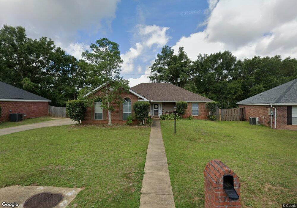
9780 Oak Forrest Dr Mobile, AL 36695
Baker NeighborhoodEstimated Value: $224,865 - $247,000
3
Beds
2
Baths
1,618
Sq Ft
$146/Sq Ft
Est. Value
About This Home
This home is located at 9780 Oak Forrest Dr, Mobile, AL 36695 and is currently estimated at $236,466, approximately $146 per square foot. 9780 Oak Forrest Dr is a home located in Mobile County with nearby schools including Elsie Collier Elementary School, Bernice J Causey Middle School, and Baker High School.
Ownership History
Date
Name
Owned For
Owner Type
Purchase Details
Closed on
Mar 21, 2003
Sold by
John Howard Homes Ltd
Bought by
Bowen Terry E and Wissman Lynell M
Current Estimated Value
Create a Home Valuation Report for This Property
The Home Valuation Report is an in-depth analysis detailing your home's value as well as a comparison with similar homes in the area
Home Values in the Area
Average Home Value in this Area
Purchase History
| Date | Buyer | Sale Price | Title Company |
|---|---|---|---|
| Bowen Terry E | $129,900 | -- |
Source: Public Records
Tax History
| Year | Tax Paid | Tax Assessment Tax Assessment Total Assessment is a certain percentage of the fair market value that is determined by local assessors to be the total taxable value of land and additions on the property. | Land | Improvement |
|---|---|---|---|---|
| 2025 | $1,886 | $18,720 | $4,000 | $14,720 |
| 2024 | $1,886 | $17,760 | $4,000 | $13,760 |
| 2023 | $1,638 | $16,890 | $4,000 | $12,890 |
| 2022 | $1,475 | $15,210 | $4,000 | $11,210 |
| 2021 | $1,450 | $14,950 | $4,000 | $10,950 |
| 2020 | $1,504 | $15,510 | $3,200 | $12,310 |
| 2019 | $1,503 | $30,980 | $0 | $0 |
| 2018 | $692 | $15,640 | $0 | $0 |
| 2017 | $703 | $14,440 | $0 | $0 |
| 2016 | $639 | $14,560 | $0 | $0 |
| 2013 | $729 | $15,560 | $0 | $0 |
Source: Public Records
Map
Nearby Homes
- 9613 Oak Forrest Place
- 9650 Oak Forrest Dr
- 9630 Oak Forrest Dr Unit 2
- 0 New Neck Rd Unit 387066
- 1170 Wellington Ct S
- 1145 Dominion Dr E
- 10023 Springfield Ct
- 9410 Ashwood Ct
- 9375 Ashwood Ct
- 1235 Wakefield Dr E
- 10061 Sasser Ln
- 10153 Tarawood Ct
- 860 Trailwood Dr E
- 10164 Waterford Way
- 9633 Royal Woods Dr S
- 9751 Pine Knoll Rd
- 10635 Burlington Estates Dr
- 835 Royal Woods Dr E
- 1040 Wakefield Dr W
- 1497 Hunters Ct
- 9790 Oak Forrest Dr
- 9770 Oak Forrest Dr
- 9760 Oak Forrest Dr
- 9800 Oak Forrest Dr
- 9775 Oak Forrest Dr
- 9750 Oak Forrest Dr Unit 3
- 9765 Oak Forrest Dr
- 9785 Oak Forrest Dr
- 9810 Oak Forrest Dr
- 9795 Oak Forrest Dr
- 9755 Oak Forrest Dr
- 9740 Oak Forrest Dr
- 9681 Firethorn Dr
- 9639 Boxford Ct
- 9662 Firethorn Dr
- 9735 Oak Forrest Dr
- 9730 Oak Forrest Dr
- 9671 Firethorn Dr
- 9631 Boxford Ct
- 9632 Boxford Ct Unit 3
Your Personal Tour Guide
Ask me questions while you tour the home.