
Seller's Agent in 2026
Tom Livingston
Jason Mitchell Real Estate Colorado, LLC
(720) 351-3396
1 in this area
81 Total Sales
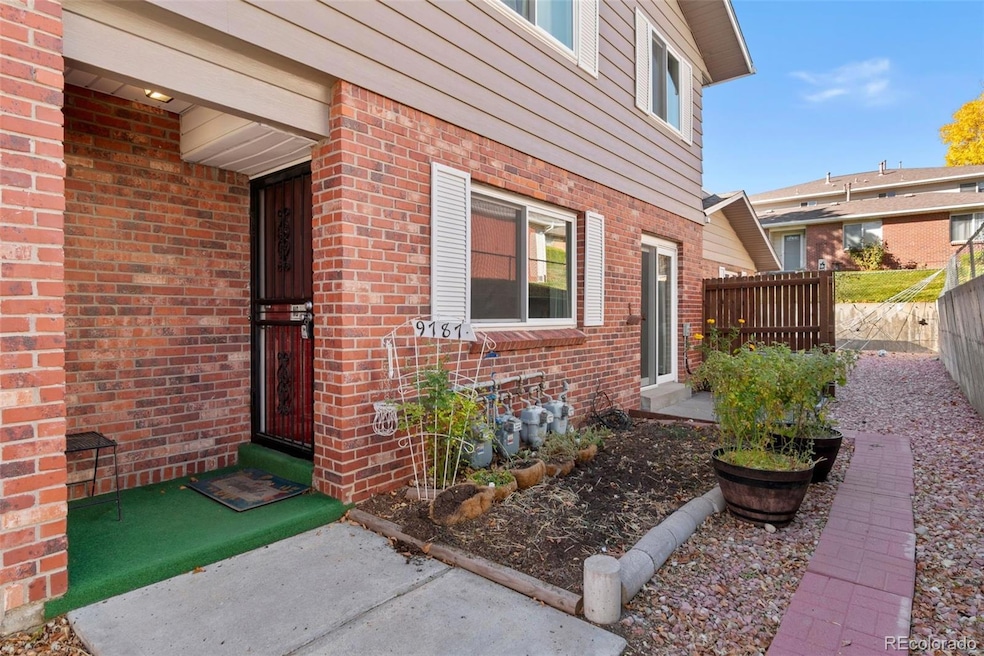
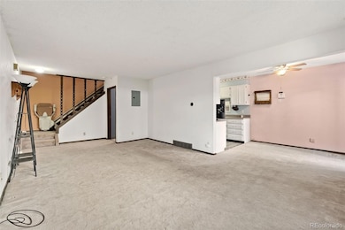
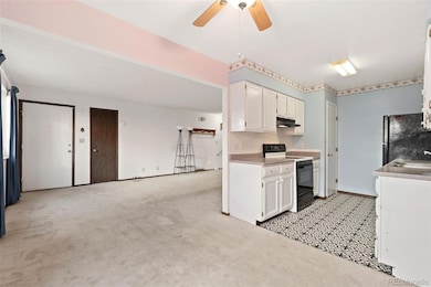
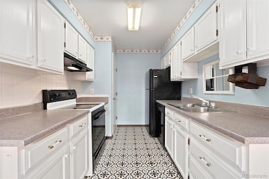
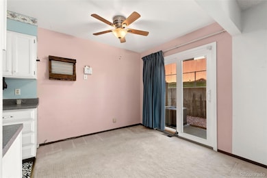

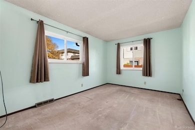
Seller is now offering six months of prepaid HOA dues! Welcome to this two-story end-unit townhome located in the heart of Thornton. Featuring 2 bedrooms and 2 bathrooms, with new interior paint and new tile in the upstairs bathroom, this home offers a spacious kitchen with a generous pantry, perfect for everyday living and meal prep. Upstairs, you'll find two large bedrooms, including a walk-in closet in the primary for added convenience. The attached one-car garage includes extra storage space, and the private patio provides a comfortable outdoor retreat. New windows and A/C unit installed in 2024.
Enjoy access to a nearby community park, clubhouse, and pool just up the street. Commuting is a breeze with easy access to I-25, making travel between Denver and the northern suburbs simple and efficient. You're just a 6-minute drive to the RTD Park-n-Ride and only 10 minutes from the Light Rail. A variety of shopping and dining options are also close by, adding to the home's convenient location.
Last Agent to Sell the Property
Jason Mitchell Real Estate Colorado, LLC Brokerage Email: tlivingston@jasonmitchellgroup.com,720-351-3396 License #100079311 Listed on: 10/11/2025
We collect this data history from publicly available records. To have your information removed, we recommend requesting removal directly through your county’s website.
| Date | Type | Sale Price | Title Company |
|---|---|---|---|
| Warranty Deed | $270,000 | Os National | |
| Quit Claim Deed | -- | Land Title Guarantee | |
| Warranty Deed | $217,000 | Heritage Title Company |
We collect this data history from publicly available records. To have your information removed, we recommend requesting removal directly through your county’s website.
| Date | Status | Loan Amount | Loan Type |
|---|---|---|---|
| Open | $265,109 | FHA | |
| Previous Owner | $119,700 | New Conventional |
| Date | Event | Price | List to Sale | Price per Sq Ft |
|---|---|---|---|---|
| 04/03/2026 04/03/26 | Sold | $270,000 | +1.9% | $233 / Sq Ft |
| 03/04/2026 03/04/26 | Pending | -- | -- | -- |
| 02/26/2026 02/26/26 | For Sale | $265,000 | -1.9% | $228 / Sq Ft |
| 02/11/2026 02/11/26 | Off Market | $270,000 | -- | -- |
| 01/22/2026 01/22/26 | Price Changed | $265,000 | -1.9% | $228 / Sq Ft |
| 01/02/2026 01/02/26 | For Sale | $270,000 | 0.0% | $233 / Sq Ft |
| 12/31/2025 12/31/25 | Off Market | $270,000 | -- | -- |
| 11/17/2025 11/17/25 | Price Changed | $270,000 | -6.9% | $233 / Sq Ft |
| 10/11/2025 10/11/25 | For Sale | $290,000 | -- | $250 / Sq Ft |
| Year | Tax Paid | Tax Assessment Tax Assessment Total Assessment is a certain percentage of the fair market value that is determined by local assessors to be the total taxable value of land and additions on the property. | Land | Improvement |
|---|---|---|---|---|
| 2025 | $1,709 | $19,790 | $4,350 | $15,440 |
| 2024 | $1,709 | $18,190 | $4,000 | $14,190 |
| 2023 | $1,692 | $20,230 | $3,110 | $17,120 |
| 2022 | $1,720 | $15,610 | $3,200 | $12,410 |
| 2021 | $1,776 | $15,610 | $3,200 | $12,410 |
| 2020 | $1,043 | $16,500 | $3,290 | $13,210 |
| 2019 | $1,045 | $16,500 | $3,290 | $13,210 |
| 2018 | $685 | $11,890 | $610 | $11,280 |
| 2017 | $621 | $11,890 | $610 | $11,280 |
| 2016 | $413 | $7,690 | $680 | $7,010 |
| 2015 | $412 | $3,850 | $340 | $3,510 |
| 2014 | -- | $3,270 | $340 | $2,930 |
Seller's Agent in 2026
Tom Livingston
Jason Mitchell Real Estate Colorado, LLC
(720) 351-3396
1 in this area
81 Total Sales
Buyer's Agent in 2026
Alaska Kuntz
Salz Home Solutions Realty
(720) 938-9157
1 in this area
8 Total Sales
Source: REcolorado®
MLS Number: 5000526
APN: 1719-16-4-03-055
Disclaimer: Certain information contained herein is derived from information provided by parties other than Homes.com. All information provided is deemed reliable, but is not guaranteed to be accurate and should be independently verified.
![]() All data is obtained from various sources and may not have been verified by broker or MLS GRID. Supplied Open House Information is subject to change without notice. All information should be independently reviewed and verified for accuracy. Properties may or may not be listed by the office/agent presenting the information. Some IDX listings have been excluded from this website. The content relating to real estate for sale in this Web site comes in part from the Internet Data eXchange (“IDX”) program of METROLIST, INC., DBA RECOLORADO®. Real estate listings held by brokers other than Ten-X are marked with the IDX Logo. This information is being provided for the consumers’ personal, non-commercial use and may not be used for any other purpose. All information is subject to change and should be independently verified.
All data is obtained from various sources and may not have been verified by broker or MLS GRID. Supplied Open House Information is subject to change without notice. All information should be independently reviewed and verified for accuracy. Properties may or may not be listed by the office/agent presenting the information. Some IDX listings have been excluded from this website. The content relating to real estate for sale in this Web site comes in part from the Internet Data eXchange (“IDX”) program of METROLIST, INC., DBA RECOLORADO®. Real estate listings held by brokers other than Ten-X are marked with the IDX Logo. This information is being provided for the consumers’ personal, non-commercial use and may not be used for any other purpose. All information is subject to change and should be independently verified.
This publication is designed to provide information with regard to the subject matter covered. It is displayed with the understanding that the publisher and authors are not engaged in rendering real estate, legal, accounting, tax, or other professional services and that the publisher and authors are not offering such advice in this publication. If real estate, legal, or other expert assistance is required, the services of a competent, professional person should be sought.
The information contained in this publication is subject to change without notice. METROLIST, INC., DBA RECOLORADO MAKES NO WARRANTY OF ANY KIND WITH REGARD TO THIS MATERIAL, INCLUDING, BUT NOT LIMITED TO, THE IMPLIED WARRANTIES OF MERCHANTABILITY AND FITNESS FOR A PARTICULAR PURPOSE. METROLIST, INC., DBA RECOLORADO SHALL NOT BE LIABLE FOR ERRORS CONTAINED HEREIN OR FOR ANY DAMAGES IN CONNECTION WITH THE FURNISHING, PERFORMANCE, OR USE OF THIS MATERIAL.
PUBLISHER’S NOTICE: All real estate advertised herein is subject to the Federal Fair Housing Act and the Colorado Fair Housing Act, which Acts make it illegal to make or publish any advertisement that indicates any preference, limitation, or discrimination based on race, color, religion, sex, handicap, familial status, or national origin.
METROLIST, INC., DBA RECOLORADO will not knowingly accept any advertising for real estate that is in violation of the law. All persons are hereby informed that all dwellings advertised are available on an equal opportunity basis.
© 2026 METROLIST, INC., DBA RECOLORADO® – All Rights Reserved. 6455 S. Yosemite St., Suite 500 Greenwood Village, CO 80111 USA
ALL RIGHTS RESERVED WORLDWIDE. No part of this publication may be reproduced, adapted, translated, stored in a retrieval system or transmitted in any form or by any means, electronic, mechanical, photocopying, recording, or otherwise, without the prior written permission of the publisher. The information contained herein including but not limited to all text, photographs, digital images, virtual tours, may be seeded and monitored for protection and tracking.
Listings courtesy of REcolorado® as distributed by MLS GRID.
Based on information submitted to the MLS GRID
Ask me questions while you tour the home.